METAR & TAF 5Y1
5Y1 does not publish a METAR.
Showing the nearest reporting station: KCIU (CHIPPEWA COUNTY INTL) · 13.1 NM away. Conditions at 5Y1 may differ.
METAR · KCIU
Observed 16:56Z
KCIU 271656Z AUTO 06006KT 7SM OVC005 22/21 A2970 RMK AO2 SLP054 T02220211 $
- Wind
- 060° @ 6 kt
- Visibility
- 7 SM
- Temp / Dew
- 22°C / 21°C
- Altimeter
- 29.70 inHg
- Clouds
- OVC
- Density alt
- 2,055 ft
- Ceiling
- 500 ft AGL
- Rules
- IFR
Airport info & contacts
Manager on record, flight service, ARTCC, attendance schedule and pattern altitude — published by the FAA and refreshed every 28 days.
Location
- From city
- 2 NM N
- VFR sectional
- LAKE HURON
- ARTCC
- ZYZ · TORONTO
- NOTAM facility
- GRB (NOTAM-D)
Airport manager
- Name
- JOSEPH BAKER
- Phone
- 989-513-2207
- Address
- PO BOX 367, CEDARVILLE MI 49719-0367
Flight service · Hours
- FSS GRB
- GREEN BAY1-800-WX-BRIEF
- Attendance
- Unattended
Frequencies
Tap any row to copy the frequency to your clipboard.
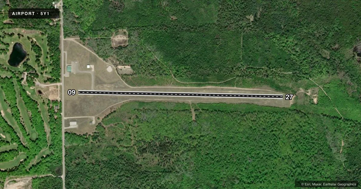
Runways & pattern
Full pagePattern entry · RWY 09
LEFT TRAFFICRunway end performance
| End | TORA | TODA | ASDA | LDA | VGSI | Approach lights | Obstruction |
|---|---|---|---|---|---|---|---|
| 09 | — | — | — | — | PAPI 2-box left(4°) | — | 15', road, 258' from thr, 0' R of cntrln, slope 3 |
| 27 | — | — | — | — | PAPI 2-box left(3.5°) | — | 45', trees, 676' from thr, 170' R of cntrln, slope 10 |
Declared distances in feet. TORA = takeoff run available, TODA = takeoff distance, ASDA = accelerate-stop, LDA = landing distance.
Airport sketch
Runways drawn to scale from FAA survey coordinates, rendered over satellite imagery. Not for navigation.
Approaches & charts
Services on the field
Fuel grades, oxygen, maintenance, ramp storage and lighting — as declared to the FAA by the airport operator.
Fuel & services
- Fuel
- 100LL
Ramp & ground
- Transient storage
- Tie-down
- Hangar
- Landing fee
- No fee published
- Lighting schedule
- SEE RMK
- Beacon schedule
- SS-SR
- Beacon
- White / Green (civil land)(WG)
- Wind indicator
- Yes
- Segmented circle
- No
Fuel & FBOs
Cheapest 100LL and Jet A on the field and nearby. Always confirm with the FBO before taxi.
Airport notes
Surface conditions, obstructions, local procedures, lighting outages and other notes published with each FAA cycle.
General notes
- FOR FICONS CALL AMGR.
- FOR CD CTC MINNEAPOLIS ARTCC AT 651-463-5588.
- DEER, BIRDS, & WILDLIFE ON & INVOF ARPT.
Lighting notes
- ACTVT PAPI RWY 09 & 27; MIRL RWY 09/27 - CTAF.
Fuel notes
- 100LLFOR AVGAS CALL 989-513-2207.
Approach & departure obstructions
- 09FADED.
- 27FADED.
- 09APCH RATIO 17:1 TO DTHR.
Other notes
- VFR OPNS ONLY.
- MANAGERMAX HEIL, ASST AMGR.
VFR map & nearby airports
VFR sectional. Tap any ICAO chip to open that airport.
Key facts · 5Y1
Answer card- ICAO
- 5Y1
- Name
- ALBERT J LINDBERG
- Location
- HESSEL, MICHIGAN
- Elevation
- 760 ft MSL
- Traffic pattern altitude
- 1,760 ft MSL (1,000 AGL)
- Control tower
- Non-towered (use CTAF)
- Total runways
- 1
- Longest runway
- 09/27 · 3,700 ft
- Published ILS approaches
- 0
- Published frequencies
- 1
- Magnetic variation
- –
- Current flight rules
- IFR
- Current wind
- 060° at 6 kt
- Favored runway now
- RWY 09
Albert J Lindberg Airport sits in Hessel, Michigan. The field elevation is 760 ft MSL. It has one runway. Runway 09/27 is 3,700 ft long with asphalt pavement. There is no control tower. CTAF is 122.9.
No ILS approaches are published here. The airport is VFR only. Pattern altitude is not published, so use the standard 1,000 ft AGL pattern unless the current FAA Chart Supplement or the airport manager tells you otherwise. Runway 09 and runway 27 both have PAPI. Medium intensity runway lights are on both ends. They are controlled by CTAF. Published remarks also note faded runway markings on both 09 and 27.
There are no on-field FBOs listed. For aviation gasoline, the published remarks give a phone number to call. For flight information services, contact the airport manager. Wildlife is a real factor here. Deer, birds and other animals are reported on and near the airport. Runway 09 also has a published approach slope note to the displaced threshold, so brief that end carefully before you arrive.