METAR & TAF 50D
50D does not publish a METAR.
Showing the nearest reporting station: KIMT (FORD) · 13.2 NM away. Conditions at 50D may differ.
METAR · KIMT
Observed 15:54Z
KIMT 271554Z AUTO 16006KT 9SM CLR 23/21 A2968 RMK AO2 LTG DSNT SE AND S RAE30 SLP045 P0003 T02280211
- Wind
- 160° @ 6 kt
- Visibility
- 9 SM
- Temp / Dew
- 23°C / 21°C
- Altimeter
- 29.68 inHg
- Clouds
- CLR
- Density alt
- 2,919 ft
- Ceiling
- Unlimited
- Rules
- VFR
Airport info & contacts
Manager on record, flight service, ARTCC, attendance schedule and pattern altitude — published by the FAA and refreshed every 28 days.
Location
- From city
- 6 NM SE
- VFR sectional
- GREEN BAY
- ARTCC
- ZMP · MINNEAPOLIS
- NOTAM facility
- GRB (NOTAM-D)
Airport manager
- Name
- KRIST ATANASOFF
- Phone
- 906-265-4106
- Address
- 303 SELDEN RD, IRON RIVER MI 49935-1831
Flight service · Hours
- FSS GRB
- GREEN BAY1-800-WX-BRIEF
- Attendance
- Unattended
Frequencies
Tap any row to copy the frequency to your clipboard.
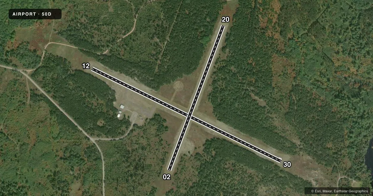
Runways & pattern
Full pagePattern entry · RWY 20
LEFT TRAFFIC| Runway | Heading (°M) | Length | Surface | Traffic |
|---|---|---|---|---|
| 12/30 | 114° / 294° | 3,690 ft | ASPH | Standard L |
| 02/20Favored | 18° / 198° | 2,700 ft | TURF | Standard L |
Runway end performance
| End | TORA | TODA | ASDA | LDA | VGSI | Approach lights | Obstruction |
|---|---|---|---|---|---|---|---|
| 12 | — | — | — | — | — | — | 33', trees, 468' from thr, 60' R of cntrln, slope 8 |
| 30 | — | — | — | — | — | — | 22', trees, 350' from thr, 130' R of cntrln, slope 6 |
| 02 | — | — | — | — | — | — | 30', trees, 40' from thr, 129' R of cntrln, slope 1 |
| 20 | — | — | — | — | — | — | 45', tree, 235' from thr, 140' R of cntrln, slope 5 |
Declared distances in feet. TORA = takeoff run available, TODA = takeoff distance, ASDA = accelerate-stop, LDA = landing distance.
Airport sketch
Runways drawn to scale from FAA survey coordinates, rendered over satellite imagery. Not for navigation.
Approaches & charts
Services on the field
Fuel grades, oxygen, maintenance, ramp storage and lighting — as declared to the FAA by the airport operator.
Fuel & services
- Fuel
- Not available
- Oxygen (bottled)
- Not available
- Oxygen (bulk)
- Not available
- Power plant repair
- Not available
Ramp & ground
- Transient storage
- Tie-down
- Landing fee
- No fee published
- Customs
- Not available
- Lighting schedule
- SEE RMK
- Wind indicator
- Lighted
- Segmented circle
- Yes
Fuel & FBOs
Cheapest 100LL and Jet A on the field and nearby. Always confirm with the FBO before taxi.
Airport notes
Surface conditions, obstructions, local procedures, lighting outages and other notes published with each FAA cycle.
General notes
- DEER, BIRDS, & WILDLIFE ON & INVOF ARPT.
- NO SNOW REMOVAL.
- ARPT CLSD NOV 15-APR 15 & WHEN SNOW COVD EXC FOR SKI EQUIPPED ACFT.
- FOR CD CTC MINNEAPOLIS ARTCC AT 651-463-5588.
Lighting notes
- ACTVT NSTD LIRL RWY 12/30 - 121.7
Runway surface & condition
- 12/30NSTD LIRL DUE TO 36 FT FM RWY EDGE.
Approach & departure obstructions
- 023 FT YELLOW CONES.
- 203 FT YELLOW CONES.
Other notes
- ROPES NOT PRVDD.
- MANAGERCELL 906-367-2563.
- 02/20ROUGH IN AREAS; NMRS CRACKS IN PAVEMENT.
- 12/30NMRS CRACKS & VEGETATION IN PAVEMENT.
VFR map & nearby airports
VFR sectional. Tap any ICAO chip to open that airport.
Key facts · 50D
Answer card- ICAO
- 50D
- Name
- IRON COUNTY
- Location
- CRYSTAL FALLS, MICHIGAN
- Elevation
- 1,340 ft MSL
- Traffic pattern altitude
- 2,340 ft MSL (1,000 AGL)
- Control tower
- Non-towered (use CTAF)
- Total runways
- 2
- Longest runway
- 12/30 · 3,690 ft
- Published ILS approaches
- 0
- Published frequencies
- 1
- Magnetic variation
- 2°
- Current flight rules
- VFR
- Current wind
- 160° at 6 kt
- Favored runway now
- RWY 20
Iron County Airport (50D) is in Crystal Falls, Michigan. Field elevation is 1,340 ft MSL. The airport has two runways. The longest is 12/30 at 3,690 ft. Runway 02/20 is turf and 2,700 ft. There is no control tower. CTAF is 122.9.
No ILS approaches are published here. Pattern altitude is not published, so use the standard 1,000 ft AGL for light piston operations unless the current Chart Supplement says otherwise. The airport is closed November 15 through April 15. It is also closed when snow covered except for ski equipped aircraft. No snow removal is provided. That matters here because winter operations are a real issue.
Published remarks also call out nonstandard low intensity runway lights on 12/30. They are activated on 121.7. Runway 12/30 has cracks and vegetation in the pavement. Runway 02/20 is rough in areas with numerous cracks. Deer, birds and other wildlife are reported on and near the airport. There are no on-field FBOs listed. Check with the airport operator or the current FAA Chart Supplement before you go. The manager cell phone number is published in the remarks if you need local status before departure.