METAR & TAF Y73
Y73 does not publish a METAR.
Showing the nearest reporting station: KLNL (KINGS LAND O' LAKES) · 24.4 NM away. Conditions at Y73 may differ.
METAR · KLNL
Observed 15:55Z
KLNL 271555Z AUTO 15006KT 10SM CLR 24/20 A2974 RMK AO2 T02400200
- Wind
- 150° @ 6 kt
- Visibility
- 10 SM
- Temp / Dew
- 24°C / 20°C
- Altimeter
- 29.74 inHg
- Clouds
- CLR
- Density alt
- 3,310 ft
- Ceiling
- Unlimited
- Rules
- VFR
Airport info & contacts
Manager on record, flight service, ARTCC, attendance schedule and pattern altitude — published by the FAA and refreshed every 28 days.
Location
- From city
- 1 NM SSE
- VFR sectional
- GREEN BAY
- ARTCC
- ZMP · MINNEAPOLIS
- NOTAM facility
- GRB (NOTAM-D)
Airport manager
- Name
- KRIST ATANASOFF
- Phone
- 906-265-6144
- Address
- 303 SELDEN RD, IRON RIVER MI 49935-1831
Flight service · Hours
- FSS GRB
- GREEN BAY1-800-WX-BRIEF
- Attendance
- Unattended
Frequencies
Tap any row to copy the frequency to your clipboard.
Runways & pattern
Full pagePattern entry · RWY 17
LEFT TRAFFICRunway end performance
| End | TORA | TODA | ASDA | LDA | VGSI | Approach lights | Obstruction |
|---|---|---|---|---|---|---|---|
| 17 | — | — | — | — | — | — | 24', trees, 345' from thr, 110' R of cntrln, slope 6 |
Declared distances in feet. TORA = takeoff run available, TODA = takeoff distance, ASDA = accelerate-stop, LDA = landing distance.
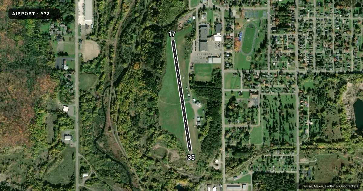
Airport sketch
Runways drawn to scale from FAA survey coordinates, rendered over satellite imagery. Not for navigation.
Approaches & charts
Services on the field
Fuel grades, oxygen, maintenance, ramp storage and lighting — as declared to the FAA by the airport operator.
Fuel & services
- Fuel
- 100LL
- Oxygen (bottled)
- Not available
- Oxygen (bulk)
- Not available
- Airframe repair
- Not available
Ramp & ground
- Transient storage
- Tie-down
- Landing fee
- No fee published
- Customs
- Not available
- Lighting schedule
- SEE RMK
- Wind indicator
- Lighted
- Segmented circle
- Yes
Fuel & FBOs
Cheapest 100LL and Jet A on the field and nearby. Always confirm with the FBO before taxi.
Airport notes
Surface conditions, obstructions, local procedures, lighting outages and other notes published with each FAA cycle.
General notes
- DEER, BIRDS, & WILDLIFE ON & INVOF ARPT.
- 100 FT DROP-OFF AFT EACH RWY END.
- RWY 17/35 DNSLP FM S TO N.
- FOR CD CTC MINNEAPOLIS ARTCC AT 651-463-5588.
Lighting notes
- ACTVT NSTD REIL RWY 17 & 35; NSTD LIRL RWY 17/35 - 121.9.
Runway surface & condition
- 17/35NSTD LIRL DUE TO LCTN 25 FT FROM RWY EDGE. THR LGTS LCTD OUTBOARD FM RWY EDGE.
Approach & departure obstructions
- 17+10 FT TREES, 0-199 FT DIST, 120 FT R.
- 17NSTD REIL OMNIDIRECTIONAL.
- 35NSTD REIL OMNIDIRECTIONAL.
Other notes
- ESTABD BFR 1959.
- ROPES NOT PRVDD.
- MANAGERCELL 906-367-2563.
VFR map & nearby airports
VFR sectional. Tap any ICAO chip to open that airport.
Key facts · Y73
Answer card- ICAO
- Y73
- Name
- STAMBAUGH
- Location
- IRON RIVER, MICHIGAN
- Elevation
- 1,618 ft MSL
- Traffic pattern altitude
- 2,618 ft MSL (1,000 AGL)
- Control tower
- Non-towered (use CTAF)
- Total runways
- 1
- Longest runway
- 17/35 · 2,000 ft
- Published ILS approaches
- 0
- Published frequencies
- 1
- Magnetic variation
- 2°
- Current flight rules
- VFR
- Current wind
- 150° at 6 kt
- Favored runway now
- RWY 17
Stambaugh Airport (Y73) sits in Iron River, Michigan. The field elevation is 1,618 ft MSL. It has one runway, 17/35, which is 2,000 ft long and asphalt. There is no control tower, so use CTAF 122.9 and standard non-towered procedures.
No ILS approaches are published here. Pattern altitude is not published, so plan on the standard 1,000 ft AGL unless the current Chart Supplement says otherwise. That puts the traffic pattern at 2,618 ft MSL based on the listed field elevation. The runway has a downslope from south to north. There is also a 100-foot drop-off after each runway end. Trees are reported near runway 17, about 120 ft right and 0 to 199 ft from the runway. Wildlife is also a real factor here.
Lighting is nonstandard. The runway edge lights are low intensity and sit close to the runway edge. Threshold lights are outboard from the runway edge. Runway end identifier lights are activated on 17 and 35. The airport was established before 1959. No on-field FBOs are listed, so call the airport operator directly or use the field on CTAF for current service details before you go.