METAR & TAF 6Y9
6Y9 does not publish a METAR.
Showing the nearest reporting station: KLNL (KINGS LAND O' LAKES) · 29.9 NM away. Conditions at 6Y9 may differ.
METAR · KLNL
Observed 18:55Z
KLNL 271855Z AUTO 35008KT 10SM BKN028 OVC034 28/21 A2972 RMK AO2 T02780206
- Wind
- 350° @ 8 kt
- Visibility
- 10 SM
- Temp / Dew
- 28°C / 21°C
- Altimeter
- 29.72 inHg
- Clouds
- OVC
- Density alt
- 3,515 ft
- Ceiling
- 2,800 ft AGL
- Rules
- MVFR
Airport info & contacts
Manager on record, flight service, ARTCC, attendance schedule and pattern altitude — published by the FAA and refreshed every 28 days.
Location
- From city
- 0 NM N
- VFR sectional
- GREEN BAY
- ARTCC
- ZMP · MINNEAPOLIS
- NOTAM facility
- GRB (NOTAM-D)
Airport manager
- Name
- BRAD FREDERICK
- Phone
- 248-761-5615
- Address
- 7370 BROADMOOR AVE SE, CALEDONIA MI 49316-9510
Flight service · Hours
- FSS GRB
- GREEN BAY1-800-WX-BRIEF
- Attendance
- Unattended
Frequencies
Tap any row to copy the frequency to your clipboard.
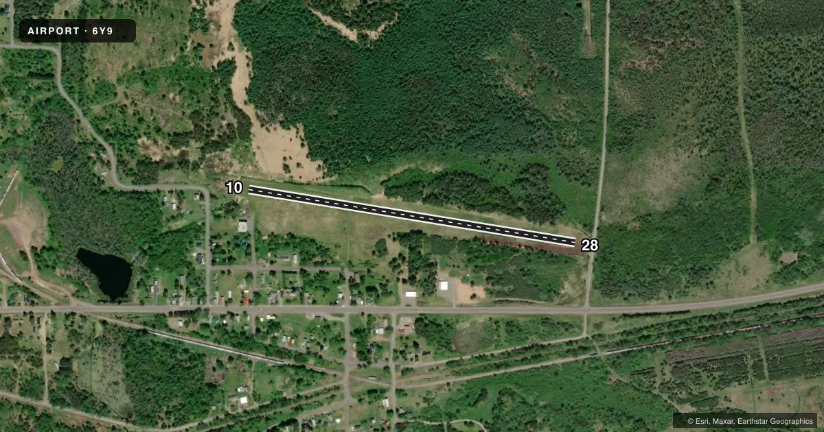
Runways & pattern
Full pagePattern entry · RWY 28
LEFT TRAFFICRunway end performance
| End | TORA | TODA | ASDA | LDA | VGSI | Approach lights | Obstruction |
|---|---|---|---|---|---|---|---|
| 10 | — | — | — | — | — | — | 30', pole, 300' from thr, 51' R of cntrln, slope 10 |
| 28 | — | — | — | — | — | — | 23', trees, 113' from thr, 40' R of cntrln, slope 4 |
Declared distances in feet. TORA = takeoff run available, TODA = takeoff distance, ASDA = accelerate-stop, LDA = landing distance.
Airport sketch
Runways drawn to scale from FAA survey coordinates, rendered over satellite imagery. Not for navigation.
Approaches & charts
Services on the field
Fuel grades, oxygen, maintenance, ramp storage and lighting — as declared to the FAA by the airport operator.
Fuel & services
- Fuel
- Not available
- Oxygen (bottled)
- Not available
- Oxygen (bulk)
- Not available
- Airframe repair
- Not available
- Power plant repair
- Not available
Ramp & ground
- Transient storage
- Tie-down
- Landing fee
- No fee published
- Customs
- Not available
- Wind indicator
- Yes
- Segmented circle
- No
Fuel & FBOs
Cheapest 100LL and Jet A on the field and nearby. Always confirm with the FBO before taxi.
Airport notes
Surface conditions, obstructions, local procedures, lighting outages and other notes published with each FAA cycle.
General notes
- ARPT CLSD NOV-MAY 15 & WHEN SNOW COVD EXC FOR SKI EQUIPPED ACFT - RWY NOT PLOWED.
- PILOT SHELTER ACES: 1-2-0-0.
- DEER, BIRDS, & WILDLIFE ON & INVOF ARPT.
- ARPT IS NEAR MTR VR 1639 & IR 609 & UNDERLIES BIG BEAR MOA. LOW LEVEL, HIGH SPEED MIL ACFT OPR IN VCNTY.
- FOR CD CTC MINNEAPOLIS ARTCC AT 651-463-5588.
Approach & departure obstructions
- 103 FT YELLOW CONES.
- 283 FT YELLOW CONES.
- 10APCH SLP TO DTHR 14:1 OVR 82 FT TREES, 1174 DIST, 30 FT L.
- 28APCH SLP TO DTHR 11:1 OVR 68 FT TREES, 750 FT DIST, 20 FT R.
Other notes
- OWNERSOUTHERN HOUGHTON COUNTY AIRPORT & HERITAGE ASSOCIATION.
- 10/28SOFT WHEN WET - CALL AMGR TO VFY FICON.
VFR map & nearby airports
VFR sectional. Tap any ICAO chip to open that airport.
Key facts · 6Y9
Answer card- ICAO
- 6Y9
- Name
- PRICKETT-GROOMS FLD
- Location
- SIDNAW, MICHIGAN
- Elevation
- 1,377 ft MSL
- Traffic pattern altitude
- 2,377 ft MSL (1,000 AGL)
- Control tower
- Non-towered (use CTAF)
- Total runways
- 1
- Longest runway
- 10/28 · 2,600 ft
- Published ILS approaches
- 0
- Published frequencies
- 1
- Magnetic variation
- 2°
- Current flight rules
- MVFR
- Current wind
- 350° at 8 kt
- Favored runway now
- RWY 28
Prickett-Grooms Fld sits in Sidnaw, Michigan. Field elevation is 1,377 ft MSL. It has one runway, 10/28, which is 2,600 ft of turf. There is no control tower. CTAF is 122.9. No ILS approaches are published here.
Pattern altitude is not published. Use 1,000 ft AGL as the standard light piston pattern unless the current Chart Supplement or local procedures say otherwise. The field is near Military Training Route 1639 and IR 609. It also lies under Big Bear Military Operations Area. Expect low-level military traffic in the area. Runway 10 and Runway 28 both have displaced-threshold obstacle notes. The runway is reported soft when wet. The airport is closed November through May 15. It is also closed when snow covered except for ski equipped aircraft. The runway is not plowed.
No on-field FBOs are listed, so verify services with the airport operator before you go. The published remarks also note pilot shelter access code 1-2-0-0. Deer, birds and other wildlife are reported on and near the airport. If you need clearance delivery, Minneapolis ARTCC is listed in the remarks. For a first-time arrival, check field condition, winter closure status and the current Chart Supplement before planning the trip.