METAR & TAF KOGM
KOGM does not publish a METAR.
Showing the nearest reporting station: KIWD (GOGEBIC/IRON COUNTY) · 36.8 NM away. Conditions at KOGM may differ.
METAR · KIWD
Observed 16:56Z
KIWD 271656Z AUTO 35008KT 320V020 10SM BKN036 BKN045 27/20 A2970 RMK AO2 SLP049 T02720200
- Wind
- 350° @ 8 kt
- Visibility
- 10 SM
- Temp / Dew
- 27°C / 20°C
- Altimeter
- 29.70 inHg
- Clouds
- BKN
- Density alt
- 2,538 ft
- Ceiling
- 3,600 ft AGL
- Rules
- VFR
Airport info & contacts
Manager on record, flight service, ARTCC, attendance schedule and pattern altitude — published by the FAA and refreshed every 28 days.
Location
- From city
- 3 NM W
- VFR sectional
- GREEN BAY
- ARTCC
- ZMP · MINNEAPOLIS
- NOTAM facility
- GRB (NOTAM-D)
Airport manager
- Name
- LISA LINNA
- Phone
- 906-884-6214
- Address
- 35932 AIRPORT RD, ONTONAGON MI 49953-9036
Flight service · Hours
- FSS GRB
- GREEN BAY1-800-WX-BRIEF
- Attendance
- Unattended
Frequencies
Tap any row to copy the frequency to your clipboard.
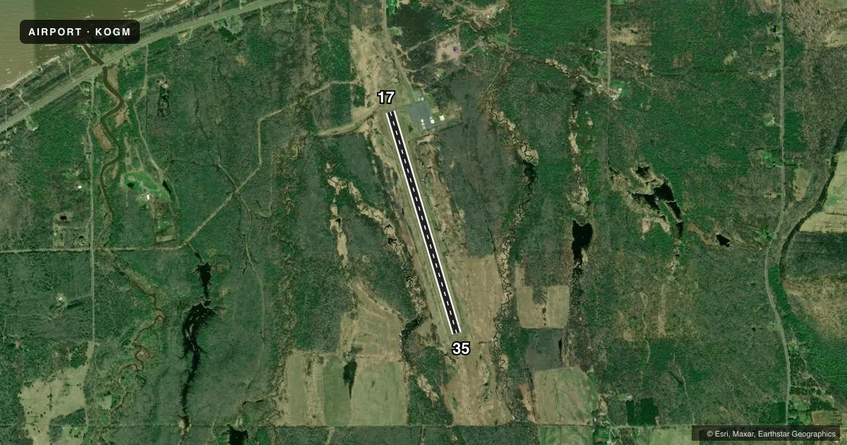
Runways & pattern
Full pagePattern entry · RWY 35
LEFT TRAFFICRunway end performance
| End | TORA | TODA | ASDA | LDA | VGSI | Approach lights | Obstruction |
|---|---|---|---|---|---|---|---|
| 17 | — | — | — | — | PAPI 2-box left(3.5°) | — | 52', trees, 1162' from thr, 317' R of cntrln, slope 18 |
| 35 | — | — | — | — | PAPI 2-box left(3.5°) | — | 20', trees, 260' from thr, 257' R of cntrln, slope 3 |
Declared distances in feet. TORA = takeoff run available, TODA = takeoff distance, ASDA = accelerate-stop, LDA = landing distance.
Airport sketch
Runways drawn to scale from FAA survey coordinates, rendered over satellite imagery. Not for navigation.
Approaches & charts
Services on the field
Fuel grades, oxygen, maintenance, ramp storage and lighting — as declared to the FAA by the airport operator.
Fuel & services
- Fuel
- 100LL
- Oxygen (bottled)
- Not available
- Oxygen (bulk)
- Not available
- Airframe repair
- Not available
- Power plant repair
- Not available
Ramp & ground
- Transient storage
- Tie-down
- Landing fee
- No fee published
- Customs
- Not available
- Lighting schedule
- SEE RMK
- Beacon schedule
- SS-SR
- Beacon
- White / Green (civil land)(WG)
- Wind indicator
- Lighted
- Segmented circle
- Yes
Fuel & FBOs
Cheapest 100LL and Jet A on the field and nearby. Always confirm with the FBO before taxi.
Airport notes
Surface conditions, obstructions, local procedures, lighting outages and other notes published with each FAA cycle.
General notes
- DEER & BIRDS ON & INVOF ARPT.
- FOR CD CTC MINNEAPOLIS ARTCC AT 651-463-5588.
- ADZY ONLY WX AVBL - 4 CLICKS CTAF.
Lighting notes
- ACTVT REIL RWY 17 & 35; PAPI RWY 17 & 35; MIRL RWY 17/35 - CTAF.
Fuel notes
- 100LLAVBL H24 SELF SVC WITH VISA OR MASTERCARD.
Approach & departure obstructions
- 3516 FT TREE, 150 FT DIST, 240 FT L.
Other notes
- MANAGERCELL 906-390-0027.
VFR map & nearby airports
VFR sectional. Tap any ICAO chip to open that airport.
Key facts · KOGM
Answer card- ICAO
- KOGM
- Name
- ONTONAGON COUNTY/SCHUSTER FLD
- Location
- ONTONAGON, MICHIGAN
- Elevation
- 665.2 ft MSL
- Traffic pattern altitude
- 1,665.2 ft MSL (1,000 AGL)
- Control tower
- Non-towered (use CTAF)
- Total runways
- 1
- Longest runway
- 17/35 · 3,503 ft
- Published ILS approaches
- 0
- Published frequencies
- 1
- Magnetic variation
- 3°
- Current flight rules
- VFR
- Current wind
- 350° at 8 kt
- Favored runway now
- RWY 35
Ontonagon County/Schuster Fld sits in Ontonagon, Michigan. Field elevation is 665.2 ft MSL. The airport has one runway. Runway 17/35 is 3,503 ft long with asphalt pavement. There is no control tower. CTAF is 122.9.
No ILS approaches are published here. Pattern altitude is not published, so use the standard 1,000 ft AGL unless the current FAA Chart Supplement or local procedures say otherwise. The field has advisory-only weather available with four clicks on CTAF. Runway end identifier lights are installed on 17 and 35. Precision approach path indicators are also on both runway ends. Medium intensity runway lights are on runway 17/35 and are controlled by CTAF.
Ontonagon County Airport is on the field and carries 100LL. It also offers 24-hour self-serve fuel with Visa or MasterCard. The manager can be reached at 906-390-0027. For clearance delivery, contact Minneapolis ARTCC at 651-463-5588. Watch for deer and birds in the area. There is also a 16-foot tree about 150 feet from runway 35, left side, on a 240-degree magnetic bearing from that threshold. For a first visit, plan for a small non-towered field with local traffic on CTAF and a short runway by piston standards.