METAR & TAF KEGV
Current METAR
Observed 17:15Z
KEGV 271715Z AUTO 00000KT 10SM SCT039 BKN047 BKN055 25/19 A2970 RMK AO2 T02450189
- Wind
- 000° @ 0 kt
- Visibility
- 10 SM
- Temp / Dew
- 25°C / 19°C
- Altimeter
- 29.70 inHg
- Clouds
- BKN
- Density alt
- 3,509 ft
- Ceiling
- 4,700 ft AGL
- Rules
- VFR
Airport info & contacts
Manager on record, flight service, ARTCC, attendance schedule and pattern altitude — published by the FAA and refreshed every 28 days.
Location
- From city
- 0 NM NW
- VFR sectional
- GREEN BAY
- ARTCC
- ZMP · MINNEAPOLIS
- NOTAM facility
- EGV (NOTAM-D)
Airport manager
- Name
- ROBERT HOM
- Phone
- 715-479-7442
- Address
- PO BOX 2320, EAGLE RIVER WI 54521
Flight service · Hours
- FSS GRB
- GREEN BAY1-800-WX-BRIEF
- Attendance
- 0830-1700
Frequencies
Tap any row to copy the frequency to your clipboard.
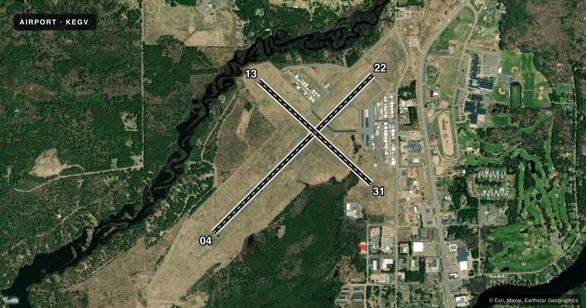
Runways & pattern
Full pagePattern entry · RWY 04
LEFT TRAFFIC| Runway | Heading (°M) | Length | Surface | Traffic |
|---|---|---|---|---|
| 04/22 | 43° / 223° | 5,000 ft | ASPH | Standard L |
| 13/31 | 130° / 310° | 3,400 ft | ASPH | Standard L |
Runway end performance
| End | TORA | TODA | ASDA | LDA | VGSI | Approach lights | Obstruction |
|---|---|---|---|---|---|---|---|
| 04 | — | — | — | — | PAPI 4-box left(3°) | — | — |
| 22 | — | — | — | — | PAPI 4-box left(3°) | — | 80', tree, 2745' from thr, 110' R of cntrln, slope 31 |
| 13 | — | — | — | — | — | — | 15', trees, 325' from thr, 100' R of cntrln, slope 8 |
Declared distances in feet. TORA = takeoff run available, TODA = takeoff distance, ASDA = accelerate-stop, LDA = landing distance.
Airport sketch
Runways drawn to scale from FAA survey coordinates, rendered over satellite imagery. Not for navigation.
Approaches & charts
ILS · 1
Services on the field
Fuel grades, oxygen, maintenance, ramp storage and lighting — as declared to the FAA by the airport operator.
Fuel & services
- Fuel
- 100LLA+
- Oxygen (bottled)
- Not available
- Oxygen (bulk)
- Low pressure
- Airframe repair
- Major
- Power plant repair
- Major
Ramp & ground
- Transient storage
- Tie-down
- Hangar
- Landing fee
- No fee published
- Customs
- Not available
- Lighting schedule
- SEE RMK
- Beacon schedule
- SS-SR
- Beacon
- White / Green (civil land)(WG)
- Wind indicator
- Lighted
- Segmented circle
- Yes
Fuel & FBOs
Cheapest 100LL and Jet A on the field and nearby. Always confirm with the FBO before taxi.
Airport notes
Surface conditions, obstructions, local procedures, lighting outages and other notes published with each FAA cycle.
General notes
- FOR CD CTC MINNEAPOLIS ARTCC AT 651-463-5588.
Lighting notes
- MIRL RWY 04/22 PRESET TO LOW SS-SR; ACTVT AND INCR INTST REIL RWY 4 & 22; PAPI RWY 4 & 22; MIRL RWY 13/31; PERI H1; TWY LGTS - CTAF.
Fuel notes
- 100LL24 HR SELF SVC FUEL AVBL WITH CREDIT CARD.
Other notes
- 1FOR ATTENDANT OTR HRS CALL 715-479-7442.
VFR map & nearby airports
VFR sectional. Tap any ICAO chip to open that airport.
Key facts · KEGV
Answer card- ICAO
- KEGV
- Name
- EAGLE RIVER UNION
- Location
- EAGLE RIVER, WISCONSIN
- Elevation
- 1,642.2 ft MSL
- Traffic pattern altitude
- 2,642.2 ft MSL (1,000 AGL)
- Control tower
- Non-towered (use CTAF)
- Total runways
- 2
- Longest runway
- 04/22 · 5,000 ft
- Published ILS approaches
- 1
- Published frequencies
- 2
- Magnetic variation
- 2°
- Current flight rules
- VFR
- Current wind
- 000° at 0 kt
- Favored runway now
- –
Eagle River Union Airport (KEGV) sits in Eagle River, Wisconsin. Field elevation is 1,642.2 ft MSL. The airport has two asphalt runways. The longest is runway 04/22 at 5,000 ft. Runway 13/31 is 3,400 ft. There is no control tower. CTAF and UNICOM are both 122.8.
One ILS approach is published for runway 04. Pattern altitude is not published in the facts, so use the standard 1,000 ft AGL for light piston operations unless the current Chart Supplement says otherwise. The field has one on-field FBO. Eagle River Union Airport carries 100LL and Jet A. Call (715) 479-7442 for current service details or after-hours help.
A few lighting details matter here. Runway 04/22 has medium intensity lights. They come up at low intensity from sunset to sunrise. The intensity can be increased. Runway end identifier lights and PAPI are on runways 04 and 22. Taxiway lights are controlled on CTAF. The airport also notes 24-hour self-serve 100LL with a credit card. For clearances, contact Minneapolis ARTCC at 651-463-5588. If you are planning a night arrival or a first trip in, verify the current Chart Supplement and expect a non-towered, self-announce environment.