METAR & TAF KARV
Current METAR
Observed 18:15Z
KARV 271815Z AUTO 00000KT 10SM SCT034 SCT045 27/20 A2969 RMK AO2 LTG DSNT S T02650202
- Wind
- 000° @ 0 kt
- Visibility
- 10 SM
- Temp / Dew
- 27°C / 20°C
- Altimeter
- 29.69 inHg
- Clouds
- SCT
- Density alt
- 3,746 ft
- Ceiling
- Unlimited
- Rules
- VFR
Airport info & contacts
Manager on record, flight service, ARTCC, attendance schedule and pattern altitude — published by the FAA and refreshed every 28 days.
Location
- From city
- 3 NM NW
- VFR sectional
- GREEN BAY
- ARTCC
- ZMP · MINNEAPOLIS
- NOTAM facility
- ARV (NOTAM-D)
Airport manager
- Name
- JESSE BIRGINAL
- Phone
- (715) 356-3891
- Address
- 1545 N. FARMING RD, WOODRUFF WI 54568
Flight service · Hours
- FSS GRB
- GREEN BAY1-800-WX-BRIEF
- Attendance
- OCT-MAY · 0800-1700
- JUN-SEP · 0800-1800
Frequencies
Tap any row to copy the frequency to your clipboard.
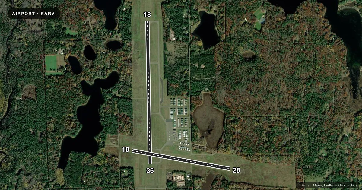
Runways & pattern
Full pagePattern entry · RWY 18
LEFT TRAFFIC| Runway | Heading (°M) | Length | Surface | Traffic |
|---|---|---|---|---|
| 18/36 | 177° / 357° | 5,150 ft | ASPH | Standard L |
| 10/28 | 99° / 279° | 3,602 ft | ASPH | Standard L |
Runway end performance
| End | TORA | TODA | ASDA | LDA | VGSI | Approach lights | Obstruction |
|---|---|---|---|---|---|---|---|
| 18 | — | — | — | — | VASI 4-box left(3°) | — | 100', trees, 3150' from thr, 400' R of cntrln, slope 29 |
| 36 | — | — | — | — | VASI 4-box left(3°) | MALSR | — |
| 10 | — | — | — | — | — | — | 71', trees, 1000' from thr, 190' R of cntrln, slope 11 |
| 28 | — | — | — | — | PAPI 2-box left(3°) | — | — |
Declared distances in feet. TORA = takeoff run available, TODA = takeoff distance, ASDA = accelerate-stop, LDA = landing distance.
Airport sketch
Runways drawn to scale from FAA survey coordinates, rendered over satellite imagery. Not for navigation.
Approaches & charts
Services on the field
Fuel grades, oxygen, maintenance, ramp storage and lighting — as declared to the FAA by the airport operator.
Fuel & services
- Fuel
- 100LLA1+
- Oxygen (bottled)
- Not available
- Airframe repair
- Minor
- Power plant repair
- Minor
- Other services
- CHTR,INSTR,RNTL
Ramp & ground
- Transient storage
- Tie-down
- Hangar
- Landing fee
- No fee published
- Customs
- Not available
- Lighting schedule
- SEE RMK
- Beacon schedule
- SS-SR
- Beacon
- White / Green (civil land)(WG)
- Wind indicator
- Lighted
- Segmented circle
- No
Fuel & FBOs
Cheapest 100LL and Jet A on the field and nearby. Always confirm with the FBO before taxi.
Airport notes
Surface conditions, obstructions, local procedures, lighting outages and other notes published with each FAA cycle.
General notes
- SANDHILL CRANES ON & INVOF ARPT.
- FOR CD IF UNA TO CTC ON FSS FREQ, CTC MINNEAPOLIS ARTCC AT 651-463-5588.
Lighting notes
- HIRL RWY 18/36 PRESET TO LOW SS-SR; INCR INTST AND ACTVT MALSR RWY 36; REIL RWY 18 & 28; VASI RWY 18 & 36; PAPI RWY 28; MIRL RWY 10/28 - CTAF.
Runway surface & condition
- 18/36NSTD HIRL; NSTD THLD LGTS MALS TYPE THLD LGT BAR IN ADDITION TO STD LGTG.
Other notes
- 1FOR ATTENDANT OTHER HRS CALL 715-490-4418.
- MANAGEREMAIL ADDRESS: LAKELANDAIRPORT@FRONTIER.COM (ALL LOWER CASE)
- OWNERTOWNS OF ARBOR VITAE, LAC DU FLAMBEAU, MINOCQUA, WOODRUFF.
VFR map & nearby airports
VFR sectional. Tap any ICAO chip to open that airport.
Key facts · KARV
Answer card- ICAO
- KARV
- Name
- LAKELAND/NOBLE F LEE MEML FLD
- Location
- MINOCQUA-WOODRUFF, WISCONSIN
- Elevation
- 1,629.5 ft MSL
- Traffic pattern altitude
- 2,629.5 ft MSL (1,000 AGL)
- Control tower
- Non-towered (use CTAF)
- Total runways
- 2
- Longest runway
- 18/36 · 5,150 ft
- Published ILS approaches
- 0
- Published frequencies
- 2
- Magnetic variation
- 2°
- Current flight rules
- VFR
- Current wind
- 000° at 0 kt
- Favored runway now
- –
Lakeland/Noble F Lee Meml Fld sits in Minocqua-Woodruff, Wisconsin. The field elevation is 1,629.5 ft MSL. It has two asphalt runways. The longest is 5,150 ft on runway 18/36. This is a non-towered field. CTAF and UNICOM are both 122.7.
No ILS approaches are published here. Pattern altitude is not published in the facts, so use the current FAA Chart Supplement before you arrive. For light piston traffic, plan on the standard 1,000 ft AGL unless the current published data says otherwise. Lakeland Aviation is on the field. It carries 100LL and Jet A. Call them at (715) 356-3891 for current services and ramp details.
Runway 18/36 has high intensity lighting with nonstandard threshold lighting. The lighting is preset low from sunset to sunrise. Runway 36 can activate MALSR lighting. Runway 18 and 28 have REILs. Runway 18 and 36 have VASI. Runway 28 has PAPI. Sandhill cranes are on and near the airport, so keep a sharp scan on final and in the pattern. If you need clearance delivery and cannot reach flight service, Minneapolis ARTCC is listed as the backup contact. For an attendant outside scheduled hours, the published number is 715-490-4418.