METAR & TAF KPKF
KPKF does not publish a METAR.
Showing the nearest reporting station: KPBH (PRICE COUNTY) · 14.8 NM away. Conditions at KPKF may differ.
METAR · KPBH
Observed 13:35Z
KPBH 271335Z AUTO 20006KT 10SM OVC006 25/25 A2971 RMK AO2 LTG DSNT NE T02510247
- Wind
- 200° @ 6 kt
- Visibility
- 10 SM
- Temp / Dew
- 25°C / 25°C
- Altimeter
- 29.71 inHg
- Clouds
- OVC
- Density alt
- 3,322 ft
- Ceiling
- 600 ft AGL
- Rules
- IFR
Airport info & contacts
Manager on record, flight service, ARTCC, attendance schedule and pattern altitude — published by the FAA and refreshed every 28 days.
Location
- From city
- 2 NM NE
- VFR sectional
- GREEN BAY
- ARTCC
- ZMP · MINNEAPOLIS
- NOTAM facility
- GRB (NOTAM-D)
Airport manager
- Name
- MICHAEL DURMEYER
- Phone
- 715-661-3217
- Address
- 400 FOURTH AVENUE SOUTH, PARK FALLS WI 54552
Flight service · Hours
- FSS GRB
- GREEN BAY1-800-WX-BRIEF
- Attendance
- Unattended
Frequencies
Tap any row to copy the frequency to your clipboard.
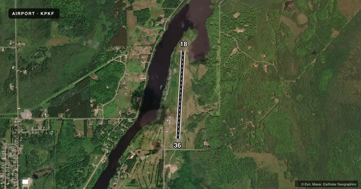
Runways & pattern
Full pagePattern entry · RWY 18
LEFT TRAFFICRunway end performance
| End | TORA | TODA | ASDA | LDA | VGSI | Approach lights | Obstruction |
|---|---|---|---|---|---|---|---|
| 18 | — | — | — | — | PAPI 2-box left(3.75°) | — | — |
| 36 | — | — | — | — | PAPI 2-box left(3°) | — | 30', trees, 475' from thr, 285' R of cntrln, slope 9 |
Declared distances in feet. TORA = takeoff run available, TODA = takeoff distance, ASDA = accelerate-stop, LDA = landing distance.
Airport sketch
Runways drawn to scale from FAA survey coordinates, rendered over satellite imagery. Not for navigation.
Approaches & charts
Services on the field
Fuel grades, oxygen, maintenance, ramp storage and lighting — as declared to the FAA by the airport operator.
Fuel & services
- Fuel
- 100LL
- Oxygen (bottled)
- Not available
- Oxygen (bulk)
- Not available
- Airframe repair
- Not available
- Power plant repair
- Not available
Ramp & ground
- Transient storage
- Tie-down
- Landing fee
- No fee published
- Customs
- Not available
- Lighting schedule
- SEE RMK
- Beacon schedule
- SS-SR
- Beacon
- White / Green (civil land)(WG)
- Wind indicator
- Lighted
- Segmented circle
- No
Fuel & FBOs
Cheapest 100LL and Jet A on the field and nearby. Always confirm with the FBO before taxi.
Airport notes
Surface conditions, obstructions, local procedures, lighting outages and other notes published with each FAA cycle.
General notes
- ARPT SFC COND NOT REPORTED.
- DEER & MIGRATORY WATERFOWL ON & INVOF ARPT.
- FOR CD CTC MINNEAPOLIS ARTCC AT 651-463-5588.
Lighting notes
- MIRL RWY 18/36 PRESET TO LOW SS-SR; TO INCR INTST & ACTVT PAPI RWYS 18 & 36 - CTAF.
Fuel notes
- 100LL24 HR SELF SERVICE FUEL WITH CREDIT CARD.
Other notes
- MANAGEREMAIL ADDRESS: AIRPORT@CITYOFPARKFALLS.COM
VFR map & nearby airports
VFR sectional. Tap any ICAO chip to open that airport.
Key facts · KPKF
Answer card- ICAO
- KPKF
- Name
- PARK FALLS MUNI
- Location
- PARK FALLS, WISCONSIN
- Elevation
- 1,500.9 ft MSL
- Traffic pattern altitude
- 2,500.9 ft MSL (1,000 AGL)
- Control tower
- Non-towered (use CTAF)
- Total runways
- 1
- Longest runway
- 18/36 · 3,200 ft
- Published ILS approaches
- 0
- Published frequencies
- 1
- Magnetic variation
- 1°
- Current flight rules
- IFR
- Current wind
- 200° at 6 kt
- Favored runway now
- RWY 18
Park Falls Muni is in Park Falls, Wisconsin. Field elevation is 1,500.9 ft MSL. The airport has one runway. Runway 18/36 is 3,200 ft asphalt, which is the longest runway on the field. There is no control tower. CTAF is 122.9.
No ILS approaches are published here. The published pattern altitude is not listed, so use the standard 1,000 ft AGL pattern unless the current Chart Supplement says otherwise. The field is set up for straightforward piston operations. The elevation is high enough that density altitude still matters on warm days. Deer and migratory waterfowl are reported on and near the airport. Keep a sharp scan on taxi, takeoff and landing.
Park Falls Municipal Airport is the on-field FBO. It carries 100LL. Twenty-four hour self-serve fuel with credit card is available for 100LL. Runway lights on 18/36 are preset to low from sunset to sunrise. Use the CTAF to increase intensity and activate the PAPI on runways 18 and 36. For clearance delivery, contact Minneapolis ARTCC at 651-463-5588. Airport surface condition is not reported, so check current conditions before you go.