METAR & TAF 5N2
5N2 does not publish a METAR.
Showing the nearest reporting station: KPBH (PRICE COUNTY) · 11.5 NM away. Conditions at 5N2 may differ.
METAR · KPBH
Observed 20:35Z
KPBH 262035Z AUTO 22008KT 10SM CLR 29/20 A2987 RMK AO2 T02920204
- Wind
- 220° @ 8 kt
- Visibility
- 10 SM
- Temp / Dew
- 29°C / 20°C
- Altimeter
- 29.87 inHg
- Clouds
- CLR
- Density alt
- 3,699 ft
- Ceiling
- Unlimited
- Rules
- VFR
Airport info & contacts
Manager on record, flight service, ARTCC, attendance schedule and pattern altitude — published by the FAA and refreshed every 28 days.
Location
- From city
- 1 NM E
- VFR sectional
- GREEN BAY
- ARTCC
- ZMP · MINNEAPOLIS
- NOTAM facility
- GRB (NOTAM-D)
Airport manager
- Name
- DALE HEIKKINEN
- Phone
- 715-360-2000
- Address
- PO BOX 108, PRENTICE WI 54556
Flight service · Hours
- FSS GRB
- GREEN BAY1-800-WX-BRIEF
- Attendance
- Unattended
Frequencies
Tap any row to copy the frequency to your clipboard.
Runways & pattern
Full pagePattern entry · RWY 27
LEFT TRAFFICRunway end performance
| End | TORA | TODA | ASDA | LDA | VGSI | Approach lights | Obstruction |
|---|---|---|---|---|---|---|---|
| 09 | — | — | — | — | — | — | 23', rr, 200' from thr, 125' R of cntrln, slope 0 |
| 27 | — | — | — | — | — | — | 8', road, 285' from thr, 0' R of cntrln, slope 11 |
Declared distances in feet. TORA = takeoff run available, TODA = takeoff distance, ASDA = accelerate-stop, LDA = landing distance.
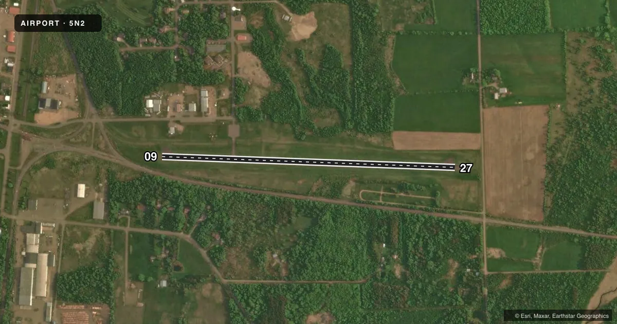
Airport sketch
Runways drawn to scale from FAA survey coordinates, rendered over satellite imagery. Not for navigation.
Approaches & charts
Services on the field
Fuel grades, oxygen, maintenance, ramp storage and lighting — as declared to the FAA by the airport operator.
Fuel & services
- Fuel
- Not available
- Oxygen (bottled)
- Not available
- Oxygen (bulk)
- Not available
- Airframe repair
- Not available
- Power plant repair
- Not available
Ramp & ground
- Transient storage
- Tie-down
- Landing fee
- No fee published
- Lighting schedule
- SEE RMK
- Beacon schedule
- SS-SR
- Beacon
- White / Green (civil land)(WG)
- Wind indicator
- Lighted
- Segmented circle
- Yes
Fuel & FBOs
Cheapest 100LL and Jet A on the field and nearby. Always confirm with the FBO before taxi.
Airport notes
Surface conditions, obstructions, local procedures, lighting outages and other notes published with each FAA cycle.
General notes
- FOR CD CTC MINNEAPOLIS ARTCC AT 651-463-5588.
Lighting notes
- ACTVT MIRL RY 09/27 & TWY LGTS - CTAF.
Approach & departure obstructions
- 09RR 200 FT FM RWY END; 125 FT R; 5 FT SIGN 190 FT FM RWY END; 63 FT L.
- 09APCH RATIO 20:1 TO DSPLCD THR.
Other notes
- PRVDD THRS ARE LCTD TO PRVD MIN 20:1 CLRNC OVER OBSTNS.
VFR map & nearby airports
VFR sectional. Tap any ICAO chip to open that airport.
Key facts · 5N2
Answer card- ICAO
- 5N2
- Name
- PRENTICE
- Location
- PRENTICE, WISCONSIN
- Elevation
- 1,578.5 ft MSL
- Traffic pattern altitude
- 2,578.5 ft MSL (1,000 AGL)
- Control tower
- Non-towered (use CTAF)
- Total runways
- 1
- Longest runway
- 09/27 · 3,134 ft
- Published ILS approaches
- 0
- Published frequencies
- 2
- Magnetic variation
- 0°
- Current flight rules
- VFR
- Current wind
- 220° at 8 kt
- Favored runway now
- RWY 27
Prentice Airport sits in Prentice, Wisconsin. Field elevation is 1,578.5 ft MSL. The airport has one runway. Runway 09/27 is 3,134 ft long with asphalt pavement. There is no control tower. CTAF and UNICOM are both 123.0. No ILS approaches are published here.
Pattern altitude is not published. Use the standard 1,000 ft AGL pattern for light piston operations unless local procedures or ATC say otherwise. The published remarks matter here. Runway 09 has displaced threshold protection based on a 20 to 1 clearance surface. There is also a railroad near the runway end on the 09 side. A small sign is also noted near that end. Medium intensity runway lights are available on 09/27. Taxiway lights are activated by using the common traffic advisory frequency.
There are no on-field FBOs listed in the facts. Plan on checking with the airport operator or the current FAA Chart Supplement before you go. For clearance delivery, Minneapolis ARTCC is the published contact. This is a non-towered field with a single short asphalt runway at a higher field elevation, so performance planning matters. Watch density altitude on warm days. The runway environment on the 09 end deserves a close look before you commit.