METAR & TAF KRRL
Current METAR
Observed 08:35Z
KRRL 270835Z AUTO 00000KT 7SM BKN120 21/19 A2979 RMK AO2 T02050192 TSNO
- Wind
- 000° @ 0 kt
- Visibility
- 7 SM
- Temp / Dew
- 21°C / 19°C
- Altimeter
- 29.79 inHg
- Clouds
- BKN
- Density alt
- 2,516 ft
- Ceiling
- 12,000 ft AGL
- Rules
- VFR
Airport info & contacts
Manager on record, flight service, ARTCC, attendance schedule and pattern altitude — published by the FAA and refreshed every 28 days.
Location
- From city
- 1 NM NW
- VFR sectional
- GREEN BAY
- ARTCC
- ZMP · MINNEAPOLIS
- NOTAM facility
- RRL (NOTAM-D)
Airport manager
- Name
- RICH MCCULLOUGH
- Phone
- 715-536-2024
- Address
- N2241 AIRPORT RD, MERRILL WI 54452
Flight service · Hours
- FSS GRB
- GREEN BAY1-800-WX-BRIEF
- Attendance
- MON-SAT · 0800-1700
Frequencies
Tap any row to copy the frequency to your clipboard.
Runways & pattern
Full pagePattern entry · RWY 07
LEFT TRAFFIC| Runway | Heading (°M) | Length | Surface | Traffic |
|---|---|---|---|---|
| 07/25 | 68° / 248° | 5,101 ft | ASPH | Standard L |
| 16/34 | 155° / 335° | 2,997 ft | ASPH | Standard L |
Runway end performance
| End | TORA | TODA | ASDA | LDA | VGSI | Approach lights | Obstruction |
|---|---|---|---|---|---|---|---|
| 07 | — | — | — | — | PAPI 2-box left(3°) | — | 55', trees, 1600' from thr, 230' R of cntrln, slope 25 |
| 25 | — | — | — | — | PAPI 2-box left(3°) | — | 35', trees, 1025' from thr, 85' R of cntrln, slope 23 |
| 34 | — | — | — | — | — | — | 83', trees, 1775' from thr, 150' R of cntrln, slope 18 |
Declared distances in feet. TORA = takeoff run available, TODA = takeoff distance, ASDA = accelerate-stop, LDA = landing distance.
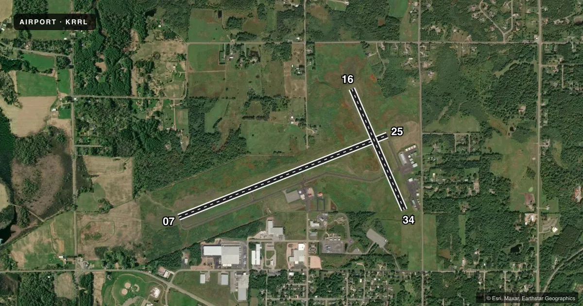
Airport sketch
Runways drawn to scale from FAA survey coordinates, rendered over satellite imagery. Not for navigation.
Approaches & charts
Services on the field
Fuel grades, oxygen, maintenance, ramp storage and lighting — as declared to the FAA by the airport operator.
Fuel & services
- Fuel
- 100LLA+
- Oxygen (bottled)
- Not available
- Oxygen (bulk)
- Not available
- Airframe repair
- Major
- Power plant repair
- Minor
- Other services
- INSTR,RNTL
Ramp & ground
- Transient storage
- Tie-down
- Hangar
- Landing fee
- No fee published
- Customs
- Not available
- Lighting schedule
- SEE RMK
- Beacon schedule
- SS-SR
- Beacon
- White / Green (civil land)(WG)
- Wind indicator
- Lighted
- Segmented circle
- Yes
Fuel & FBOs
Cheapest 100LL and Jet A on the field and nearby. Always confirm with the FBO before taxi.
Airport notes
Surface conditions, obstructions, local procedures, lighting outages and other notes published with each FAA cycle.
General notes
- ULTRALIGHT ACT ON & INVOF ARPT.
- FOR CD CTC MINNEAPOLIS ARTCC AT 651-463-5588.
- TURF AREA AVBL FOR ACFT OPS ALONG RSA NORTH OF RWY 7/25 PVMT ENDS. MKD WITH WHITE MKRS. USE AT PILOT OWN RISK.
Lighting notes
- MIRL RWY 07/25 PRESET TO LOW SS-SR; TO INCR INTST & ACTVT REIL RWY 07 & 25; PAPI RWY 07 & 25; MIRL RWY 16/34; - CTAF.
Fuel notes
- 100LLFUEL AVBL H24 VIA CREDIT CARD.
VFR map & nearby airports
VFR sectional. Tap any ICAO chip to open that airport.
Key facts · KRRL
Answer card- ICAO
- KRRL
- Name
- MERRILL MUNI
- Location
- MERRILL, WISCONSIN
- Elevation
- 1,318.2 ft MSL
- Traffic pattern altitude
- 2,318.2 ft MSL (1,000 AGL)
- Control tower
- Non-towered (use CTAF)
- Total runways
- 2
- Longest runway
- 07/25 · 5,101 ft
- Published ILS approaches
- 0
- Published frequencies
- 2
- Magnetic variation
- 1°
- Current flight rules
- VFR
- Current wind
- 000° at 0 kt
- Favored runway now
- –
Merrill Muni is in Merrill, Wisconsin. The field elevation is 1,318.2 ft MSL. It has two asphalt runways. The longest is 07/25 at 5,101 ft. There is no control tower, so expect non-towered traffic flow on CTAF 122.8. No ILS approaches are published here.
Pattern altitude is not published. Use the standard 1,000 ft AGL pattern for light piston operations unless local procedures or current airport information say otherwise. The airport has one on-field FBO, Merrill Municipal Airport. It carries AVGAS 100LL and JET A PRIST. Fuel is available 24 hours a day via credit card.
A few operational items matter here. Ultralight activity occurs on and near the airport, so keep a sharp scan in the pattern and on departure. Runway 07/25 has medium intensity lights that sit at low setting from sunset to sunrise. Use CTAF to raise intensity and turn on the runway end identifier lights. Precision approach path indicators are installed on 07 and 25. Runway 16/34 also has medium intensity lighting controlled by CTAF. For clearance delivery, contact Minneapolis ARTCC at 651-463-5588. If you need current noise or local operating guidance, check the current FAA Chart Supplement or call the airport operator directly.