METAR & TAF KSTE
Current METAR
Observed 14:55Z
KSTE 271455Z AUTO 19008KT 10SM SCT060 31/24 A2971 RMK AO2 LTG DSNT N T03050244
- Wind
- 190° @ 8 kt
- Visibility
- 10 SM
- Temp / Dew
- 31°C / 24°C
- Altimeter
- 29.71 inHg
- Clouds
- SCT
- Density alt
- 3,557 ft
- Ceiling
- Unlimited
- Rules
- VFR
Airport info & contacts
Manager on record, flight service, ARTCC, attendance schedule and pattern altitude — published by the FAA and refreshed every 28 days.
Location
- From city
- 3 NM NE
- VFR sectional
- GREEN BAY
- ARTCC
- ZMP · MINNEAPOLIS
- NOTAM facility
- STE (NOTAM-D)
Airport manager
- Name
- JASON DRAHEIM
- Phone
- 715-345-8993
- Address
- 4501 HWY 66, STEVENS POINT WI 54482
Flight service · Hours
- FSS GRB
- GREEN BAY1-800-WX-BRIEF
- Attendance
- MON-FRI · 0730-1630
- SAT-SUN · ON CALL
Frequencies
Tap any row to copy the frequency to your clipboard.
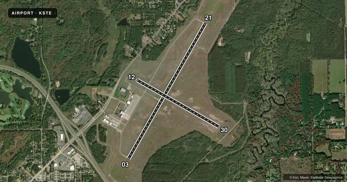
Runways & pattern
Full pagePattern entry · RWY 21
LEFT TRAFFIC| Runway | Heading (°M) | Length | Surface | Traffic |
|---|---|---|---|---|
| 03/21Favored | 29° / 209° | 6,028 ft | ASPH | Standard L |
| 12/30 | 119° / 299° | 3,635 ft | ASPH | Standard L |
Runway end performance
| End | TORA | TODA | ASDA | LDA | VGSI | Approach lights | Obstruction |
|---|---|---|---|---|---|---|---|
| 03 | — | — | — | — | PAPI 2-box left(3°) | — | 40', trees, 1140' from thr, 600' R of cntrln, slope 23 |
| 21 | — | — | — | — | PAPI 4-box left(3°) | MALS | 16', trees, 265' from thr, 510' R of cntrln, slope 4 |
| 12 | — | — | — | — | — | — | 56', trees, 745' from thr, 320' R of cntrln, slope 9 |
| 30 | — | — | — | — | — | — | 15', trees, 340' from thr, 205' R of cntrln, slope 9 |
Declared distances in feet. TORA = takeoff run available, TODA = takeoff distance, ASDA = accelerate-stop, LDA = landing distance.
Airport sketch
Runways drawn to scale from FAA survey coordinates, rendered over satellite imagery. Not for navigation.
Approaches & charts
ILS · 1
Services on the field
Fuel grades, oxygen, maintenance, ramp storage and lighting — as declared to the FAA by the airport operator.
Fuel & services
- Fuel
- 100LLA+
- Airframe repair
- Not available
- Power plant repair
- Not available
Ramp & ground
- Transient storage
- Tie-down
- Hangar
- Landing fee
- No fee published
- Customs
- Not available
- Lighting schedule
- SEE RMK
- Beacon schedule
- SS-SR
- Beacon
- White / Green (civil land)(WG)
- Wind indicator
- Lighted
- Segmented circle
- Yes
Fuel & FBOs
Cheapest 100LL and Jet A on the field and nearby. Always confirm with the FBO before taxi.
Airport notes
Surface conditions, obstructions, local procedures, lighting outages and other notes published with each FAA cycle.
General notes
- MIGRATORY WATERFOWL ON & INVOF ARPT.
- FOR CD CTC MINNEAPOLIS ARTCC AT 651-463-5588.
Lighting notes
- HIRL ON ACTV RWY PRESET TO LOW SS-SR; TO INCR INTST AND ACTVT MALS RWY 21; REIL RWY 03; PAPI RWY 03 & 21; HIRL RWY 03/21 & RWY 12/30 - CTAF.
Fuel notes
- 100LL24 HR SELF SVC FUEL AVBL WITH CREDIT CARD.
Other notes
- THIS AIRPORT HAS BEEN SURVEYED BY THE NATIONAL GEODETIC SURVEY.
- MANAGEREMAIL ADDRESS: JDRAHEIM@STEVENSPOINT.COM (ALL LOWER CASE)
- MANAGERAFT HRS CALL 715-345-8989; OPTION 3.
VFR map & nearby airports
VFR sectional. Tap any ICAO chip to open that airport.
Key facts · KSTE
Answer card- ICAO
- KSTE
- Name
- STEVENS POINT MUNI
- Location
- STEVENS POINT, WISCONSIN
- Elevation
- 1,110 ft MSL
- Traffic pattern altitude
- 2,110 ft MSL (1,000 AGL)
- Control tower
- Non-towered (use CTAF)
- Total runways
- 2
- Longest runway
- 03/21 · 6,028 ft
- Published ILS approaches
- 1
- Published frequencies
- 2
- Magnetic variation
- 1°
- Current flight rules
- VFR
- Current wind
- 190° at 8 kt
- Favored runway now
- RWY 21
Stevens Point Muni sits in Stevens Point, Wisconsin. Field elevation is 1,110 ft MSL. The airport has two asphalt runways. The longest is runway 03/21 at 6,028 ft. The field is non-towered, so expect self-announced traffic on CTAF 122.7. Pattern altitude is not published. Use the standard 1,000 ft AGL pattern unless local procedures or current guidance say otherwise.
Runway 21 has an ILS approach. That matters here because the field also publishes high intensity lighting on both runways. The lights are preset low from sunset to sunrise. Use CTAF to increase intensity. That also activates MALSR on runway 21, REIL on runway 03, PAPI on runways 03 and 21, plus HIRL on both runways. The airport is surveyed by the National Geodetic Survey. Migratory waterfowl are reported on and near the airport, so keep a sharp scan on arrival and departure.
On field, Stevens Point Municipal Airport carries 100LL and Jet A. Twenty-four hour self-service fuel is available with credit card. For clearance delivery, contact Minneapolis ARTCC at 651-463-5588. After hours, call 715-345-8989 and choose option 3. If you are planning a first trip in, brief the runway 21 ILS. Watch for bird activity. Confirm lighting needs before night operations.