METAR & TAF W23
W23 does not publish a METAR.
Showing the nearest reporting station: KPCZ (WAUPACA MUNI) · 11.7 NM away. Conditions at W23 may differ.
METAR · KPCZ
Observed 17:35Z
KPCZ 261735Z AUTO 21006KT 10SM SCT025 BKN031 29/21 A2993 RMK AO2 T02910214
- Wind
- 210° @ 6 kt
- Visibility
- 10 SM
- Temp / Dew
- 29°C / 21°C
- Altimeter
- 29.93 inHg
- Clouds
- BKN
- Density alt
- 2,794 ft
- Ceiling
- 3,100 ft AGL
- Rules
- VFR
Airport info & contacts
Manager on record, flight service, ARTCC, attendance schedule and pattern altitude — published by the FAA and refreshed every 28 days.
Location
- From city
- 2 NM NE
- VFR sectional
- CHICAGO
- ARTCC
- ZAU · CHICAGO
- NOTAM facility
- GRB (NOTAM-D)
Airport manager
- Name
- VILLAGE OF WILD ROSE
- Phone
- 920-540-2660
- Address
- N6041 COUNTY RD K, WILD ROSE WI 54989
Flight service · Hours
- FSS GRB
- GREEN BAY1-800-WX-BRIEF
- Attendance
- Unattended
Frequencies
Tap any row to copy the frequency to your clipboard.
Runways & pattern
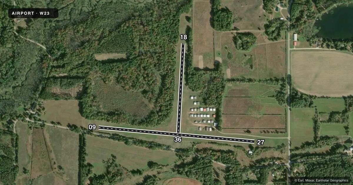
Full pagePattern entry · RWY 18
LEFT TRAFFIC| Runway | Heading (°M) | Length | Surface | Traffic |
|---|---|---|---|---|
| 09/27 | 95° / 275° | 2,990 ft | TURF | Standard L |
| 18/36Favored | 183° / 3° | 1,710 ft | TURF | Standard L |
Runway end performance
| End | TORA | TODA | ASDA | LDA | VGSI | Approach lights | Obstruction |
|---|---|---|---|---|---|---|---|
| 09 | — | — | — | — | — | — | 15', road, 0' from thr, 120' R of cntrln, slope 0 |
| 27 | — | — | — | — | — | — | 10', road, 0' from thr, 90' R of cntrln, slope 0 |
| 18 | — | — | — | — | — | — | 50', trees, 0' from thr, 115' R of cntrln, slope 0 |
| 36 | — | — | — | — | — | — | 69', trees, 387' from thr, 130' R of cntrln, slope 5 |
Declared distances in feet. TORA = takeoff run available, TODA = takeoff distance, ASDA = accelerate-stop, LDA = landing distance.
Airport sketch
Runways drawn to scale from FAA survey coordinates, rendered over satellite imagery. Not for navigation.
Approaches & charts
Services on the field
Fuel grades, oxygen, maintenance, ramp storage and lighting — as declared to the FAA by the airport operator.
Fuel & services
- Fuel
- Not available
- Oxygen (bottled)
- Not available
- Oxygen (bulk)
- Not available
- Airframe repair
- Not available
- Power plant repair
- Not available
Ramp & ground
- Transient storage
- Tie-down
- Lighting schedule
- SEE RMK
- Beacon schedule
- SS-SR
- Beacon
- White / Green (civil land)(WG)
- Wind indicator
- Yes
- Segmented circle
- Yes
Fuel & FBOs
Cheapest 100LL and Jet A on the field and nearby. Always confirm with the FBO before taxi.
Airport notes
Surface conditions, obstructions, local procedures, lighting outages and other notes published with each FAA cycle.
General notes
- ULTRALIGHT ACTVTY ON & IN VCNTY OF ARPT.
- DEER & CRANES ON & INVOF ARPT.
- FOR CD CTC CHICAGO ARTCC AT 630-906-8921.
Lighting notes
- ACTVT LIRL RY 09/27 - CTAF.
Runway surface & condition
- 09/27RY 09/27 NSTD THRESHOLD LGHTS, DO NOT COMPLY WITH FAA STANDARD.
Approach & departure obstructions
- 09RY 09 /27 MKD WITH YELLOW CONES.
- 18RY 18/36 MKD WITH YELLOW CONES.
Other notes
- PRVDD OBSTNS IN RWY APCH SFCS ARE REMOVED/LOWERED OR THRS DSPLCD TO PRVD 20:1 CLRNC.
- OWNERLEASED TO WILD ROSE ARPT ASSOCIATION.
- MANAGERCLERK@VI.WILDROSE.WI.GOV.
- OWNERCLERK@VI.WILDROSE.WI.GOV.
- 09/27PLOWED WINTER MONTHS.
- 18/36CLSD NOV 15 THRU APR 1.
VFR map & nearby airports
VFR sectional. Tap any ICAO chip to open that airport.
Key facts · W23
Answer card- ICAO
- W23
- Name
- WILD ROSE IDLEWILD
- Location
- WILD ROSE, WISCONSIN
- Elevation
- 908 ft MSL
- Traffic pattern altitude
- 1,908 ft MSL (1,000 AGL)
- Control tower
- Non-towered (use CTAF)
- Total runways
- 2
- Longest runway
- 09/27 · 2,990 ft
- Published ILS approaches
- 0
- Published frequencies
- 2
- Magnetic variation
- 0°
- Current flight rules
- VFR
- Current wind
- 210° at 6 kt
- Favored runway now
- RWY 18
Wild Rose Idlewild Airport is in Wild Rose, Wisconsin. The field elevation is 908 ft MSL. It has two turf runways. The longest is 09/27 at 2,990 ft. There is no control tower. CTAF and UNICOM are both 122.8. No ILS approaches are published.
Pattern altitude is not published. Use the standard 1,000 ft AGL pattern unless local procedures or current published data say otherwise. That puts the light piston pattern at about 1,908 ft MSL based on field elevation. Runway 09/27 is marked with yellow cones. It is plowed in winter. It also has activated low intensity runway lights controlled by CTAF. The published remarks also note nonstandard threshold lights on 09/27. Runway 18/36 is closed from November 15 through April 1.
There are no on-field FBOs listed, so plan fuel and service with the airport operator or the FBO directly by phone before arrival. The published remarks also call out deer, cranes and ultralight activity in and near the airport. That matters here. Keep a sharp scan on approach and in the pattern. The airport is leased to the Wild Rose Airport Association. If you need current operating details or any local restrictions, check the current FAA Chart Supplement before you go.