METAR & TAF KPCZ
Current METAR
Observed 17:15Z
KPCZ 261715Z AUTO 00000KT 10SM BKN029 BKN033 29/21 A2994 RMK AO2 T02930212
- Wind
- 000° @ 0 kt
- Visibility
- 10 SM
- Temp / Dew
- 29°C / 21°C
- Altimeter
- 29.94 inHg
- Clouds
- BKN
- Density alt
- 2,697 ft
- Ceiling
- 2,900 ft AGL
- Rules
- MVFR
Airport info & contacts
Manager on record, flight service, ARTCC, attendance schedule and pattern altitude — published by the FAA and refreshed every 28 days.
Location
- From city
- 3 NM SE
- VFR sectional
- GREEN BAY
- ARTCC
- ZMP · MINNEAPOLIS
- NOTAM facility
- PCZ (NOTAM-D)
Airport manager
- Name
- MATHEW KLATT
- Phone
- 715-258-4427
- Address
- 2601 RUNWAY DRIVE, WAUPACA WI 54981
Flight service · Hours
- FSS GRB
- GREEN BAY1-800-WX-BRIEF
- Attendance
- MON-FRI · 0800-1700
- SEP - MAY · 0800-1700
Frequencies
Tap any row to copy the frequency to your clipboard.
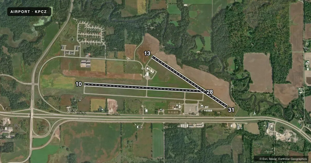
Runways & pattern
Full pagePattern entry · RWY 10
LEFT TRAFFIC| Runway | Heading (°M) | Length | Surface | Traffic |
|---|---|---|---|---|
| 10/28 | 92° / 272° | 5,200 ft | ASPH | Standard L |
| 13/31 | 122° / 302° | 3,899 ft | ASPH | Standard L |
Runway end performance
| End | TORA | TODA | ASDA | LDA | VGSI | Approach lights | Obstruction |
|---|---|---|---|---|---|---|---|
| 10 | — | — | — | — | PAPI 2-box left(3°) | — | — |
| 28 | — | — | — | — | PAPI 2-box left(3°) | — | 59', trees, 1500' from thr, 350' R of cntrln, slope 22 |
| 13 | — | — | — | — | PAPI 4-box left(4°) | — | 75', trees, 1330' from thr, 210' R of cntrln, slope 15 |
| 31 | — | — | — | — | PAPI 2-box left(3°) | — | — |
Declared distances in feet. TORA = takeoff run available, TODA = takeoff distance, ASDA = accelerate-stop, LDA = landing distance.
Airport sketch
Runways drawn to scale from FAA survey coordinates, rendered over satellite imagery. Not for navigation.
Approaches & charts
Services on the field
Fuel grades, oxygen, maintenance, ramp storage and lighting — as declared to the FAA by the airport operator.
Fuel & services
- Fuel
- 100LLA+
- Oxygen (bottled)
- Not available
- Oxygen (bulk)
- Not available
- Airframe repair
- Major
- Power plant repair
- Major
- Other services
- AMB,INSTR,RNTL
Ramp & ground
- Transient storage
- Tie-down
- Hangar
- Landing fee
- No fee published
- Customs
- Not available
- Lighting schedule
- SEE RMK
- Beacon schedule
- SS-SR
- Beacon
- White / Green (civil land)(WG)
- Wind indicator
- Lighted
- Segmented circle
- Yes
Fuel & FBOs
Cheapest 100LL and Jet A on the field and nearby. Always confirm with the FBO before taxi.
Airport notes
Surface conditions, obstructions, local procedures, lighting outages and other notes published with each FAA cycle.
General notes
- TWY LGTS AT ENTRANCE ONLY.
- FOR CD CTC MINNEAPOLIS ARTCC AT 651-463-5588.
Lighting notes
- ACTVT REIL RWY 10 & 28; MIRL RWY 13/31 - CTAF. MIRL RWY 10/28 PRESET TO LOW SS-SR; TO INCR INTST & ACTVT - CTAF.
Fuel notes
- 100LL24 HR FUEL AVBL WITH CREDIT CARD.
Approach & departure obstructions
- 13MRKGS FADED.
- 31MRKGS FADED.
- 10PAPI ON CONTINUOUSLY.
- 13PAPI ON CONTINUOUSLY.
- 28PAPI ON CONTINUOUSLY.
- 31PAPI ON CONTINUOUSLY.
Other notes
- 1OPEN MEMORIAL DAY TO LABOR DAY.
- MANAGERAFT HRS CALL 920-225-9881.
- 13/31NMRS CRACKS AND VEGETATION IN PAVEMENT.
VFR map & nearby airports
VFR sectional. Tap any ICAO chip to open that airport.
Key facts · KPCZ
Answer card- ICAO
- KPCZ
- Name
- WAUPACA MUNI
- Location
- WAUPACA, WISCONSIN
- Elevation
- 840.2 ft MSL
- Traffic pattern altitude
- 1,840.2 ft MSL (1,000 AGL)
- Control tower
- Non-towered (use CTAF)
- Total runways
- 2
- Longest runway
- 10/28 · 5,200 ft
- Published ILS approaches
- 0
- Published frequencies
- 3
- Magnetic variation
- 1°
- Current flight rules
- MVFR
- Current wind
- 000° at 0 kt
- Favored runway now
- –
Waupaca Muni is in Waupaca, Wisconsin. Field elevation is 840.2 ft MSL. The airport has two asphalt runways. The longest is runway 10/28 at 5,200 ft. Runway 13/31 is 3,899 ft. This is an untowered field, so plan to self-announce on CTAF 122.8 and watch the pattern closely. Pattern altitude is not published. Use the standard 1,000 ft AGL pattern for light piston traffic unless the current FAA Chart Supplement says otherwise.
No ILS approaches are published here. The airport does have published lighting notes. Runway end identifier lights are on 10 and 28. Medium intensity runway lights are on 13/31 and are controlled by CTAF. The 10/28 lights are preset low from sunset to sunrise. Use CTAF to raise intensity and activate them. The precision approach path indicator is listed as on continuously for all four runway ends. Taxiway lights are only at the entrance. Runway 13/31 also has numerous cracks and vegetation in the pavement. Runway 31 markings are faded.
Klatt Aero is on the field. It carries 100LL and Jet A Prist. 24-hour fuel is available with credit card. After hours, call the number in the Chart Supplement or the FBO directly. For clearance delivery, contact Minneapolis ARTCC. If you need current procedures or any local restrictions, check the current FAA Chart Supplement before departure.