METAR & TAF KATW
Current METAR
Observed 12:45Z
KATW 271245Z COR 21008G16KT 5SM BR BKN006 27/26 A2977
- Wind
- 210° @ 8G16 kt
- Visibility
- 5 SM
- Temp / Dew
- 27°C / 26°C
- Altimeter
- 29.77 inHg
- Clouds
- BKN
- Density alt
- 2,764 ft
- Ceiling
- 600 ft AGL
- Rules
- IFR
Airport info & contacts
Manager on record, flight service, ARTCC, attendance schedule and pattern altitude — published by the FAA and refreshed every 28 days.
Location
- From city
- 3 NM W
- VFR sectional
- GREEN BAY
- ARTCC
- ZMP · MINNEAPOLIS
- NOTAM facility
- ATW (NOTAM-D)
Airport manager
- Name
- ABE WEBER, AIRPORT DIRECTOR
- Phone
- 920-832-5267
- Address
- W6390 CHALLENGER DR-SUITE 201, APPLETON WI 54914-9119
Flight service · Hours
- FSS GRB
- GREEN BAY1-800-WX-BRIEF
- Attendance
- ALL
Frequencies
Tap any row to copy the frequency to your clipboard.
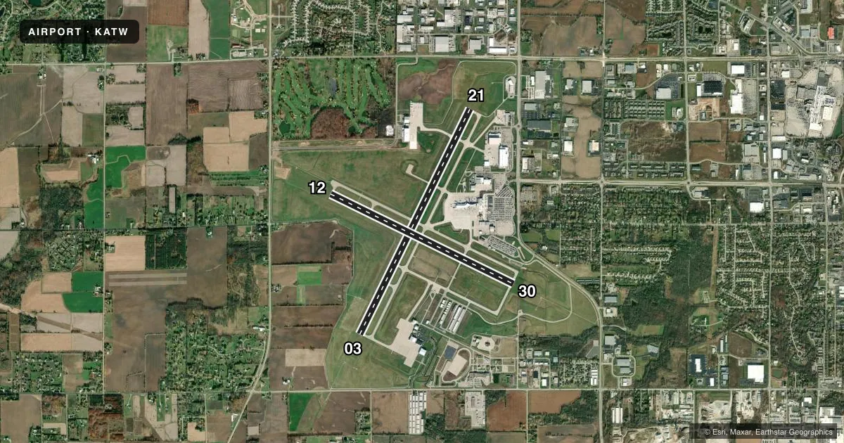
Runways & pattern
Full pagePattern entry · RWY 21
LEFT TRAFFIC| Runway | Heading (°M) | Length | Surface | Traffic |
|---|---|---|---|---|
| 03/21Favored | 24° / 204° | 8,003 ft | CONC | Standard L |
| 12/30 | 114° / 294° | 6,502 ft | CONC | Standard L |
Runway end performance
| End | TORA | TODA | ASDA | LDA | VGSI | Approach lights | Obstruction |
|---|---|---|---|---|---|---|---|
| 03 | 8,002' | 8,002' | 8,002' | 8,002' | PAPI 4-box left(3°) | MALSR | 56', tree, 2400' from thr, 200' R of cntrln, slope 39 |
| 21 | 8,002' | 8,002' | 8,002' | 8,002' | PAPI 4-box left(3°) | — | 62', tree, 2600' from thr, 350' R of cntrln, slope 38 |
| 12 | 6,501' | 6,501' | 6,501' | 6,501' | PAPI 4-box left(3°) | — | 57', tree, 2800' from thr, 350' R of cntrln, slope 45 |
| 30 | 6,501' | 6,501' | 6,501' | 6,501' | PAPI 4-box left(3°) | MALSR | — |
Declared distances in feet. TORA = takeoff run available, TODA = takeoff distance, ASDA = accelerate-stop, LDA = landing distance.
Airport sketch
Runways drawn to scale from FAA survey coordinates, rendered over satellite imagery. Not for navigation.
Approaches & charts
ILS · 2
Services on the field
Fuel grades, oxygen, maintenance, ramp storage and lighting — as declared to the FAA by the airport operator.
Fuel & services
- Fuel
- 100LLA
- Oxygen (bottled)
- Not available
- Oxygen (bulk)
- HIGH/LOW
- Airframe repair
- Major
- Power plant repair
- Major
- Other services
- AFRT,AVNCS,CHTR,INSTR,RNTL,SALES
Ramp & ground
- Transient storage
- Tie-down
- Hangar
- Landing fee
- No fee published
- Customs
- Not available
- Lighting schedule
- SEE RMK
- Beacon schedule
- SS-SR
- Beacon
- White / Green (civil land)(WG)
- Wind indicator
- Lighted
- Segmented circle
- No
Fuel & FBOs
Cheapest 100LL and Jet A on the field and nearby. Always confirm with the FBO before taxi.
Airport notes
Surface conditions, obstructions, local procedures, lighting outages and other notes published with each FAA cycle.
General notes
- BIRDS & MIGRATORY WATERFOWL ON & INVOF ARPT.
- SNOW REMOVAL OPNS IN PROGRESS WINTER MONTHS. VEHICLE OPERATORS WILL BE MONITORING CTAF; ACFT LNDG/DEP APPLETON SHOULD USE CTAF WHEN ATCT CLSD.
- US CSTMS AND BORDER PROTECTION. PPR US CSTMS SVC MON-FRI 1300-2100Z (0800-1600 LOCAL) CALL 920-968-2348.
- WHEN ATCT CLSD, FOR CD CTC GREEN BAY APCH ON FREQ, IF UNA CTC MINNEAPOLIS ARTCC AT 651-463-5588.
- PERIODIC LIVE FIRE TRNG SOUTH SIDE OF ARPT.
- COML RAMP DEICING PADS ARE AVBL FOR LIVE ENG RUN OPN DRG DEICING.
Lighting notes
- WHEN ATCT CLSD HIRL RWY 03/21 PRESET ON LOW INTST; TO INCR INTST & ACTVT MALSR RWY 03, 30; REIL RWY 12, 21; PAPI RWY 12; HIRL RWY 03/21, 12/30 - CTAF.
Runway surface & condition
- 03/21PCR VALUE: 1000/R/C/W/T
- 12/30PCR VALUE: 730/R/C/W/T
Approach & departure obstructions
- 03OPERATES CONTINUOUSLY.
- 21OPERATES CONTINUOUSLY. PAPI RESTRICTED BYD 8.5 DEG RGT OF COURSE.
- 30OPERATES CONTINUOUSLY.
VFR map & nearby airports
VFR sectional. Tap any ICAO chip to open that airport.
Key facts · KATW
Answer card- ICAO
- KATW
- Name
- APPLETON INTL
- Location
- APPLETON, WISCONSIN
- Elevation
- 918 ft MSL
- Traffic pattern altitude
- 1,918 ft MSL (1,000 AGL)
- Control tower
- Towered · 0530-2300
- Total runways
- 2
- Longest runway
- 03/21 · 8,003 ft
- Published ILS approaches
- 2
- Published frequencies
- 7
- Magnetic variation
- 2°
- Current flight rules
- IFR
- Current wind
- 210° at 8 kt
- Favored runway now
- RWY 21
Appleton Intl sits in Appleton, Wisconsin at 918 ft MSL. It has two concrete runways. The longest is 8,003 ft on 03/21. The other runway is 12/30 at 6,502 ft. The field is towered from 0530 to 2300. When the tower is closed, use CTAF 119.6 for traffic and for runway light control. ILS approaches are published for runway ends 03 and 30. Pattern altitude is not published in the facts, so use the standard 1,000 ft AGL for light piston traffic unless the current Chart Supplement says otherwise.
Appleton Flight Center is on the field. It carries 100LL, Jet A and Jet A Prist. If you need fuel or ramp details, call them at (920) 738-3034 before you go. The airport also has CBP prior permission required service Monday through Friday from 1300 to 2100Z. The published remarks also note birds and migratory waterfowl in the area. Winter snow removal is active. Expect ground activity on the common traffic advisory frequency when the tower is closed.
For a first-time arrival, pay attention to the lighting setup after hours. CTAF controls the high intensity lights and the approach lighting system. The airport sits in a busy commercial environment. Expect normal tower sequencing during the day and verify any current procedures in the FAA Chart Supplement before departure.