METAR & TAF 11Y
11Y does not publish a METAR.
Showing the nearest reporting station: KOSH (WITTMAN RGNL) · 16.5 NM away. Conditions at 11Y may differ.
METAR · KOSH
Observed 13:13Z
KOSH 271313Z AUTO 18011KT 4SM BR BKN003 OVC007 26/26 A2976 RMK AO2 T02610256
- Wind
- 180° @ 11 kt
- Visibility
- 4 SM
- Temp / Dew
- 26°C / 26°C
- Altimeter
- 29.76 inHg
- Clouds
- OVC
- Density alt
- 2,651 ft
- Ceiling
- 300 ft AGL
- Rules
- LIFR
Airport info & contacts
Manager on record, flight service, ARTCC, attendance schedule and pattern altitude — published by the FAA and refreshed every 28 days.
Location
- From city
- 2 NM NW
- VFR sectional
- GREEN BAY
- ARTCC
- ZMP · MINNEAPOLIS
- NOTAM facility
- GRB (NOTAM-D)
Airport manager
- Name
- DEAN HEIMERMANN
- Phone
- 920-849-2199
- Address
- W3124 HICKORY HILLS RD, CHILTON WI 53014
Flight service · Hours
- FSS GRB
- GREEN BAY1-800-WX-BRIEF
- Attendance
- Unattended
Frequencies
Tap any row to copy the frequency to your clipboard.
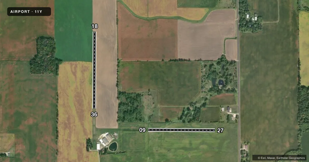
Runways & pattern
Full pagePattern entry · RWY 18
LEFT TRAFFIC| Runway | Heading (°M) | Length | Surface | Traffic |
|---|---|---|---|---|
| 18/36Favored | 180° / 0° | 1,680 ft | TURF | Standard L |
| 09/27 | 90° / 270° | 1,463 ft | TURF | Standard L |
Runway end performance
| End | TORA | TODA | ASDA | LDA | VGSI | Approach lights | Obstruction |
|---|---|---|---|---|---|---|---|
| 36 | — | — | — | — | — | — | 70', tree, 820' from thr, 55' R of cntrln, slope 11 |
Declared distances in feet. TORA = takeoff run available, TODA = takeoff distance, ASDA = accelerate-stop, LDA = landing distance.
Airport sketch
Runways drawn to scale from FAA survey coordinates, rendered over satellite imagery. Not for navigation.
Approaches & charts
Services on the field
Fuel grades, oxygen, maintenance, ramp storage and lighting — as declared to the FAA by the airport operator.
Fuel & services
- Fuel
- Not available
- Oxygen (bottled)
- Not available
- Oxygen (bulk)
- Not available
- Airframe repair
- Not available
- Power plant repair
- Not available
Ramp & ground
- Transient storage
- Not published
- Wind indicator
- Yes
- Segmented circle
- No
Fuel & FBOs
Cheapest 100LL and Jet A on the field and nearby. Always confirm with the FBO before taxi.
Airport notes
Surface conditions, obstructions, local procedures, lighting outages and other notes published with each FAA cycle.
General notes
- FOR CD CTC CHICAGO ARTCC AT 630-906-8921.
- FQT CROP DUSTING ACT ON & INVOF ARPT.
- SEASONAL 8 FT CORN ADJ TO RWYS.
Approach & departure obstructions
- 09MKD WITH HALF BARRELS.
- 18MKD WITH HALF BARRELS.
- 27MKD WITH HALF BARRELS.
- 36MKD WITH HALF BARRELS.
Other notes
- PRVDD VFR OPNS ONLY; AND CLEAR 20:1 APPCHS ESTABLISHED.
VFR map & nearby airports
VFR sectional. Tap any ICAO chip to open that airport.
Key facts · 11Y
Answer card- ICAO
- 11Y
- Name
- FLYING FEATHERS
- Location
- CHILTON, WISCONSIN
- Elevation
- 913 ft MSL
- Traffic pattern altitude
- 1,913 ft MSL (1,000 AGL)
- Control tower
- Non-towered (use CTAF)
- Total runways
- 2
- Longest runway
- 18/36 · 1,680 ft
- Published ILS approaches
- 0
- Published frequencies
- 1
- Magnetic variation
- –
- Current flight rules
- LIFR
- Current wind
- 180° at 11 kt
- Favored runway now
- RWY 18
Flying Feathers (11Y) sits in Chilton, Wisconsin. The field elevation is 913 ft MSL. It has two turf runways. The longest is runway 18/36 at 1,680 ft. Runway 09/27 is 1,463 ft. There is no control tower. CTAF is 122.9.
No ILS approaches are published here. Published remarks say this field is for VFR operations only. The remarks also note clear 20 to 1 approaches. That matters if you are planning a low and slow arrival or departure. Runway 18, runway 36, runway 09 and runway 27 are all marked with half barrels. Seasonal 8 foot corn is adjacent to the runways. Frequent crop dusting activity is also reported on and near the airport. Keep your scan outside. Expect traffic that may not be on a standard pattern.
Pattern altitude is not published. Use the standard 1,000 ft AGL for light piston aircraft unless the current Chart Supplement says otherwise. There are no on-field FBOs listed. For clearance delivery, contact Chicago ARTCC at 630-906-8921. If you are planning a first visit, treat this as a small turf strip with limited room for error. Verify current conditions, runway surface and local traffic before you go.