METAR & TAF KMTW
Current METAR
Observed 02:56Z
KMTW 270256Z AUTO 20007KT 9SM CLR 23/23 A2982 RMK AO2 SLP094 T02330233 55008 $
- Wind
- 200° @ 7 kt
- Visibility
- 9 SM
- Temp / Dew
- 23°C / 23°C
- Altimeter
- 29.82 inHg
- Clouds
- CLR
- Density alt
- 1,891 ft
- Ceiling
- Unlimited
- Rules
- VFR
Airport info & contacts
Manager on record, flight service, ARTCC, attendance schedule and pattern altitude — published by the FAA and refreshed every 28 days.
Location
- From city
- 2 NM NW
- VFR sectional
- GREEN BAY
- ARTCC
- ZMP · MINNEAPOLIS
- NOTAM facility
- MTW (NOTAM-D)
Airport manager
- Name
- BRYAN BARBEAU
- Phone
- 920-323-6522
- Address
- 1815 FREEDOM WAY, MANITOWOC WI 54220
Flight service · Hours
- FSS GRB
- GREEN BAY1-800-WX-BRIEF
- Attendance
- MON-FRI · 0700-1700
- SAT · 0700-1300
Frequencies
Tap any row to copy the frequency to your clipboard.
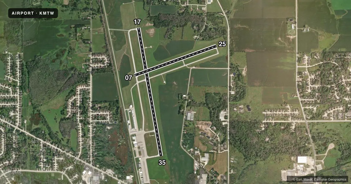
Runways & pattern
Full pagePattern entry · RWY 17
LEFT TRAFFIC| Runway | Heading (°M) | Length | Surface | Traffic |
|---|---|---|---|---|
| 17/35Favored | 168° / 348° | 5,001 ft | ASPH | Standard L |
| 07/25 | 68° / 248° | 3,341 ft | ASPH | Standard L |
Runway end performance
| End | TORA | TODA | ASDA | LDA | VGSI | Approach lights | Obstruction |
|---|---|---|---|---|---|---|---|
| 17 | — | — | — | — | PAPI 4-box left(3°) | MALSR | 20', trees, 200' from thr, 480' R of cntrln, slope 0 |
| 35 | — | — | — | — | PAPI 4-box left(3°) | — | 66', trees, 1400' from thr, 575' R of cntrln, slope 18 |
Declared distances in feet. TORA = takeoff run available, TODA = takeoff distance, ASDA = accelerate-stop, LDA = landing distance.
Airport sketch
Runways drawn to scale from FAA survey coordinates, rendered over satellite imagery. Not for navigation.
Approaches & charts
ILS · 1
Services on the field
Fuel grades, oxygen, maintenance, ramp storage and lighting — as declared to the FAA by the airport operator.
Fuel & services
- Fuel
- 100LLA+MOGAS
- Oxygen (bottled)
- Not available
- Oxygen (bulk)
- Not available
- Airframe repair
- Minor
- Power plant repair
- Minor
- Other services
- RNTL
Ramp & ground
- Transient storage
- Tie-down
- Hangar
- Landing fee
- No fee published
- Customs
- Not available
- Lighting schedule
- SEE RMK
- Beacon schedule
- SS-SR
- Beacon
- White / Green (civil land)(WG)
- Wind indicator
- Lighted
- Segmented circle
- No
Fuel & FBOs
Cheapest 100LL and Jet A on the field and nearby. Always confirm with the FBO before taxi.
Airport notes
Surface conditions, obstructions, local procedures, lighting outages and other notes published with each FAA cycle.
General notes
- GEESE & NUMEROUS BIRDS ON & INVOF ARPT.
Lighting notes
- HIRL RWY 17/35 PRESET TO LOW SS-SR; TO INCR INTST AND ACTVT MALSR RWY 17; REIL RWY 35; PAPI RWY 17 & 35; HIRL RWY 17/35; MIRL RWY 07/25 - CTAF.
Fuel notes
- 100LL24 HR SELF SVC FUEL AVBL WITH CREDIT CARD.
Other notes
- 4AFT HRS CTC AMGR.
VFR map & nearby airports
VFR sectional. Tap any ICAO chip to open that airport.
Key facts · KMTW
Answer card- ICAO
- KMTW
- Name
- MANITOWOC COUNTY
- Location
- MANITOWOC, WISCONSIN
- Elevation
- 650.9 ft MSL
- Traffic pattern altitude
- 1,650.9 ft MSL (1,000 AGL)
- Control tower
- Non-towered (use CTAF)
- Total runways
- 2
- Longest runway
- 17/35 · 5,001 ft
- Published ILS approaches
- 1
- Published frequencies
- 4
- Magnetic variation
- 2°
- Current flight rules
- VFR
- Current wind
- 200° at 7 kt
- Favored runway now
- RWY 17
Manitowoc County Airport sits in Manitowoc, Wisconsin. Field elevation is 650.9 ft MSL. The airport has two asphalt runways. The longest is runway 17/35 at 5,001 ft. There is no control tower. CTAF and UNICOM are both 122.8. Approach and departure service is handled by Green Bay on 120.2 and 338.2.
Runway 17 has the ILS. Precision approach path indicators are on runways 17 and 35. The high intensity lights on 17/35 are preset to low from sunset to sunrise. Use CTAF to increase intensity. Use CTAF to activate the medium intensity approach lighting system with runway alignment indicator lights for runway 17. Runway end identifier lights are on runway 35. The field also has medium intensity lights on runway 07/25.
Pattern altitude is not published. Use standard 1,000 ft AGL for light piston operations unless the current Chart Supplement says otherwise. On the field, Manitowoc County Airport offers AVGAS 100LL, JET A PRIST and MOGAS. Twenty-four hour self-service 100LL is available with a credit card. After hours, contact the airport manager. Watch for geese and numerous birds in the area. If you are planning a night arrival or an ILS into runway 17, brief the lighting setup before you go.