METAR & TAF 8D1
8D1 does not publish a METAR.
Showing the nearest reporting station: KSBM (SHEBOYGAN COUNTY MEML INTL) · 15.5 NM away. Conditions at 8D1 may differ.
METAR · KSBM
Observed 09:53Z
KSBM 270953Z AUTO 19004KT 9SM BKN100 23/22 A2980 RMK AO2 SLP084 T02280217 $
- Wind
- 190° @ 4 kt
- Visibility
- 9 SM
- Temp / Dew
- 23°C / 22°C
- Altimeter
- 29.80 inHg
- Clouds
- BKN
- Density alt
- 2,339 ft
- Ceiling
- 10,000 ft AGL
- Rules
- VFR
Airport info & contacts
Manager on record, flight service, ARTCC, attendance schedule and pattern altitude — published by the FAA and refreshed every 28 days.
Location
- From city
- 1 NM W
- VFR sectional
- CHICAGO
- ARTCC
- ZAU · CHICAGO
- NOTAM facility
- GRB (NOTAM-D)
Airport manager
- Name
- PERRY WELCH
- Phone
- 920-219-0015
- Address
- 2110 WASHINGTON ST, NEW HOLSTEIN WI 53061
Flight service · Hours
- FSS GRB
- GREEN BAY1-800-WX-BRIEF
- Attendance
- Unattended
Frequencies
Tap any row to copy the frequency to your clipboard.
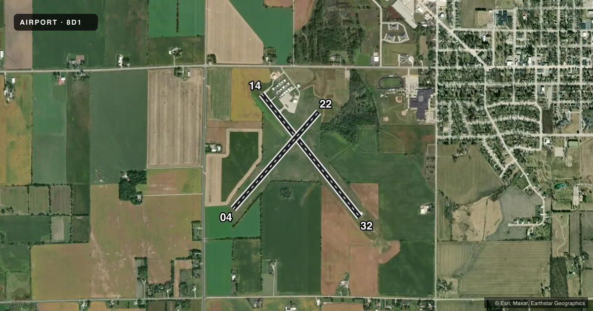
Runways & pattern
Full pagePattern entry · RWY 22
RIGHT TRAFFIC| Runway | Heading (°M) | Length | Surface | Traffic |
|---|---|---|---|---|
| 14/32 | 138° / 318° | 3,600 ft | ASPH | Standard L |
| 04/22Favored | 38° / 218° | 2,951 ft | TURF | 22 R |
Runway end performance
| End | TORA | TODA | ASDA | LDA | VGSI | Approach lights | Obstruction |
|---|---|---|---|---|---|---|---|
| 14 | — | — | — | — | PAPI 2-box left(3.2°) | — | 65', trees, 1240' from thr, 385' R of cntrln, slope 16 |
| 32 | — | — | — | — | PAPI 2-box left(3°) | — | — |
| 22 | — | — | — | — | — | — | 63', trees, 935' from thr, 200' R of cntrln, slope 14 |
Declared distances in feet. TORA = takeoff run available, TODA = takeoff distance, ASDA = accelerate-stop, LDA = landing distance.
Airport sketch
Runways drawn to scale from FAA survey coordinates, rendered over satellite imagery. Not for navigation.
Approaches & charts
Services on the field
Fuel grades, oxygen, maintenance, ramp storage and lighting — as declared to the FAA by the airport operator.
Fuel & services
- Fuel
- 100LL
- Airframe repair
- Major
- Power plant repair
- Major
Ramp & ground
- Transient storage
- Tie-down
- Hangar
- Landing fee
- No fee published
- Customs
- Not available
- Lighting schedule
- SEE RMK
- Beacon schedule
- SS-SR
- Beacon
- White / Green (civil land)(WG)
- Wind indicator
- Lighted
- Segmented circle
- Yes
Fuel & FBOs
Cheapest 100LL and Jet A on the field and nearby. Always confirm with the FBO before taxi.
Airport notes
Surface conditions, obstructions, local procedures, lighting outages and other notes published with each FAA cycle.
General notes
- NUMEROUS BIRDS INVOF ARPT.
- FOR CD CTC CHICAGO ARTCC AT 630-906-8921.
- WINGSPAN RSTRNS ARE CURRENTLY IN EFCT ON TXLS C, D, AND E.
Lighting notes
- TO INCR INTST & ACTVT REIL RWY 14/32; PAPI RWY 14/32; MIRL RWY 14/32 PRESET TO LOW SS-SR - CTAF.
Fuel notes
- 100LL24 HR SELF SVC FUEL WITH CREDIT CARD.
Runway surface & condition
- 04/22NOT PLOWED, CFM CONDS WITH AMGR.
Approach & departure obstructions
- 04MKD WITH ORANGE/WHITE A-FRAMES.
- 22MKD WITH ORANGE/WHITE A-FRAMES.
VFR map & nearby airports
VFR sectional. Tap any ICAO chip to open that airport.
Key facts · 8D1
Answer card- ICAO
- 8D1
- Name
- NEW HOLSTEIN MUNI
- Location
- NEW HOLSTEIN, WISCONSIN
- Elevation
- 992.2 ft MSL
- Traffic pattern altitude
- 1,992.2 ft MSL (1,000 AGL)
- Control tower
- Non-towered (use CTAF)
- Total runways
- 2
- Longest runway
- 14/32 · 3,600 ft
- Published ILS approaches
- 0
- Published frequencies
- 4
- Magnetic variation
- 3°
- Current flight rules
- VFR
- Current wind
- 190° at 4 kt
- Favored runway now
- RWY 22
New Holstein Muni sits in New Holstein, Wisconsin. Field elevation is 992.2 ft MSL. The airport has two runways. The longest is runway 14/32 at 3,600 ft of asphalt. Runway 04/22 is 2,951 ft of turf. There is no control tower. Pattern altitude is not published, so use the standard 1,000 ft AGL for light piston operations unless the current Chart Supplement says otherwise.
No ILS approaches are published here. CTAF and UNICOM are both 123.0. Milwaukee approach and departure are on 127.0 and 263.075. Welch's Aviation Service is on the field. It carries 100LL. 24-hour self-service fuel with credit card is available for 100LL. Published remarks also call out wingspan limits on taxiways C, D and E. Birds are reported in the area. Keep a sharp scan on arrival and departure.
Runway lighting on 14/32 can be brought up from the CTAF. That includes the runway end identifier lights, the PAPI on 14/32 and the medium intensity runway lights when they are preset to low from sunset to sunrise. Runway 22 has orange and white A-frames. Runway 04/22 is not plowed. Confirm surface conditions with the airport manager before planning a winter arrival.