METAR & TAF KFLD
Current METAR
Observed 19:53Z
KFLD 261953Z AUTO 27004KT 10SM CLR 30/22 A2987 RMK AO2 SLP108 T03000222
- Wind
- 270° @ 4 kt
- Visibility
- 10 SM
- Temp / Dew
- 30°C / 22°C
- Altimeter
- 29.87 inHg
- Clouds
- CLR
- Density alt
- 2,865 ft
- Ceiling
- Unlimited
- Rules
- VFR
Airport info & contacts
Manager on record, flight service, ARTCC, attendance schedule and pattern altitude — published by the FAA and refreshed every 28 days.
Location
- From city
- 1 NM W
- VFR sectional
- CHICAGO
- ARTCC
- ZAU · CHICAGO
- NOTAM facility
- FLD (NOTAM-D)
Airport manager
- Name
- BRYAN LINGER
- Phone
- 920-926-0653
- Address
- 260 S. ROLLING MEADOWS DRIVE, FOND DU LAC WI 54937
Flight service · Hours
- FSS GRB
- GREEN BAY1-800-WX-BRIEF
- Attendance
- 0800-1800
Frequencies
Tap any row to copy the frequency to your clipboard.
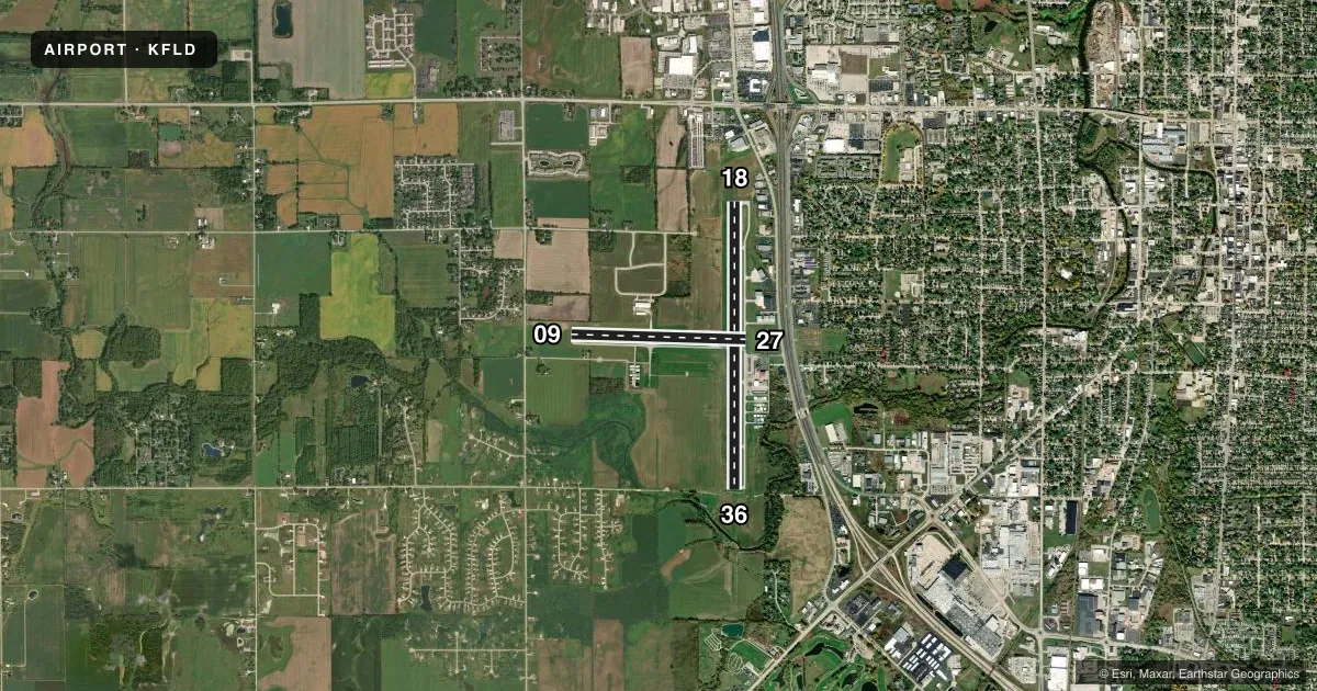
Runways & pattern
Full pagePattern entry · RWY 27
LEFT TRAFFIC| Runway | Heading (°M) | Length | Surface | Traffic |
|---|---|---|---|---|
| 18/36 | 176° / 356° | 5,941 ft | ASPH | 18 R |
| 09/27Favored | 88° / 268° | 3,604 ft | ASPH | 09 R |
Runway end performance
| End | TORA | TODA | ASDA | LDA | VGSI | Approach lights | Obstruction |
|---|---|---|---|---|---|---|---|
| 18 | — | — | — | — | PAPI 4-box left(3°) | — | 7', bldg, 200' from thr, 440' R of cntrln, slope 0 |
| 36 | — | — | — | — | PAPI 4-box left(3°) | MALSR | 17', tree, 425' from thr, 480' R of cntrln, slope 13 |
Declared distances in feet. TORA = takeoff run available, TODA = takeoff distance, ASDA = accelerate-stop, LDA = landing distance.
Airport sketch
Runways drawn to scale from FAA survey coordinates, rendered over satellite imagery. Not for navigation.
Approaches & charts
ILS · 1
Services on the field
Fuel grades, oxygen, maintenance, ramp storage and lighting — as declared to the FAA by the airport operator.
Fuel & services
- Fuel
- 100LLA
- Oxygen (bottled)
- Not available
- Oxygen (bulk)
- Not available
- Airframe repair
- Major
- Power plant repair
- Major
- Other services
- CHTR,INSTR,RNTL,SALES
Ramp & ground
- Transient storage
- Tie-down
- Hangar
- Landing fee
- No fee published
- Customs
- Not available
- Lighting schedule
- SEE RMK
- Beacon schedule
- SS-SR
- Beacon
- White / Green (civil land)(WG)
- Wind indicator
- Lighted
- Segmented circle
- Yes
Fuel & FBOs
Cheapest 100LL and Jet A on the field and nearby. Always confirm with the FBO before taxi.
Airport notes
Surface conditions, obstructions, local procedures, lighting outages and other notes published with each FAA cycle.
General notes
- FOR CD IF UNA TO CTC ON FSS FREQ, CTC CHICAGO ARTCC AT 630-906-8921.
Lighting notes
- HIRL RWY 18/36 PRESET TO LOW SS-SR; TO INCR INTST AND ACTVT MALSR RWY 36; REIL RWY 18; PAPI RWY 18 & 36; MIRL RWY 09/27 - CTAF.
Approach & departure obstructions
- 187 FT BLDG 180 FT FM RWY END, 440 L.
- 18CTLNG OBSTN EXCEEDS A 45 DEG SLP.
Other notes
- 1FOR ATTENDANT AFT HRS CALL 920-922-6000.
VFR map & nearby airports
VFR sectional. Tap any ICAO chip to open that airport.
Key facts · KFLD
Answer card- ICAO
- KFLD
- Name
- FOND DU LAC COUNTY
- Location
- FOND DU LAC, WISCONSIN
- Elevation
- 808.6 ft MSL
- Traffic pattern altitude
- 1,808.6 ft MSL (1,000 AGL)
- Control tower
- Non-towered (use CTAF)
- Total runways
- 2
- Longest runway
- 18/36 · 5,941 ft
- Published ILS approaches
- 1
- Published frequencies
- 4
- Magnetic variation
- 4°
- Current flight rules
- VFR
- Current wind
- 270° at 4 kt
- Favored runway now
- RWY 27
Fond du Lac County Airport sits in Fond du Lac, Wisconsin. Field elevation is 808.6 ft MSL. The airport has two asphalt runways. The longest is runway 18/36 at 5,941 ft. There is no control tower, so expect non-towered traffic flow on CTAF 123.05. Pattern altitude is not published, so use the standard 1,000 ft AGL for light piston operations unless the current Chart Supplement says otherwise.
One ILS approach is published for runway 36. That makes the field useful when the weather drops. You still need to brief the local procedures before arrival. Fond Du Lac Skyport is on the field. It carries 100LL, Jet A and Jet A Prist. Call (920) 922-6000 for current service or after-hours help.
A few remarks matter here. There is a building close to the departure end of runway 18. The published obstacle note says it exceeds a 45 degree slope. Runway 18/36 lighting is preset low from sunset to sunrise. Use CTAF to increase intensity and to activate the medium intensity approach lighting system for runway 36. Runway end identifier lights are on runway 18. If you are new to the area, keep the Milwaukee approach frequencies handy for IFR coordination. Check the current Chart Supplement for any noise or curfew restrictions before flying into the field.