METAR & TAF 79C
79C does not publish a METAR.
Showing the nearest reporting station: KATW (APPLETON INTL) · 6.2 NM away. Conditions at 79C may differ.
METAR · KATW
Observed 16:45Z
KATW 261645Z 00000KT 10SM SCT028 29/22 A2992
- Wind
- 000° @ 0 kt
- Visibility
- 10 SM
- Temp / Dew
- 29°C / 22°C
- Altimeter
- 29.92 inHg
- Clouds
- SCT
- Density alt
- 2,727 ft
- Ceiling
- Unlimited
- Rules
- VFR
Airport info & contacts
Manager on record, flight service, ARTCC, attendance schedule and pattern altitude — published by the FAA and refreshed every 28 days.
Location
- From city
- 4 NM SW
- VFR sectional
- GREEN BAY
- ARTCC
- ZMP · MINNEAPOLIS
- NOTAM facility
- GRB (NOTAM-D)
Airport manager
- Name
- KEITH MUSTAIN
- Phone
- 920-376-0064
- Address
- 2947 RYF RD, OSHKOSH WI 54904
Flight service · Hours
- FSS GRB
- GREEN BAY1-800-WX-BRIEF
- Attendance
- MON-FRI · 0800-1630
- SAT · 0800-1200
Frequencies
Tap any row to copy the frequency to your clipboard.
Runways & pattern
Full pagePattern entry · RWY 18
LEFT TRAFFICRunway end performance
| End | TORA | TODA | ASDA | LDA | VGSI | Approach lights | Obstruction |
|---|---|---|---|---|---|---|---|
| 18 | — | — | — | — | PAPI 2-box left(4°) | — | 36', trees, 200' from thr, 90' R of cntrln, slope 0 |
| 36 | — | — | — | — | PAPI 2-box right(4°) | — | 45', tree, 750' from thr, 110' R of cntrln, slope 12 |
Declared distances in feet. TORA = takeoff run available, TODA = takeoff distance, ASDA = accelerate-stop, LDA = landing distance.
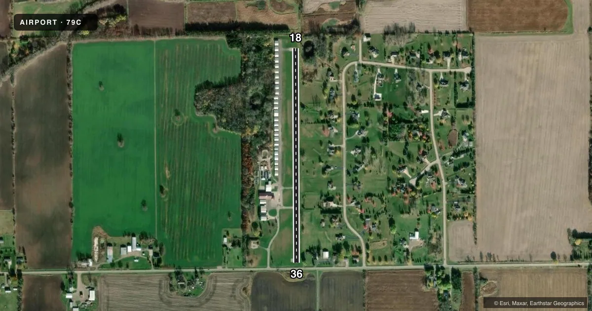
Airport sketch
Runways drawn to scale from FAA survey coordinates, rendered over satellite imagery. Not for navigation.
Approaches & charts
Services on the field
Fuel grades, oxygen, maintenance, ramp storage and lighting — as declared to the FAA by the airport operator.
Fuel & services
- Fuel
- 100LL
- Oxygen (bottled)
- Not available
- Oxygen (bulk)
- Not available
- Airframe repair
- Major
- Power plant repair
- Major
- Other services
- INSTR
Ramp & ground
- Transient storage
- Tie-down
- Landing fee
- No fee published
- Customs
- Not available
- Lighting schedule
- SEE RMK
- Wind indicator
- Lighted
- Segmented circle
- No
Fuel & FBOs
Cheapest 100LL and Jet A on the field and nearby. Always confirm with the FBO before taxi.
Airport notes
Surface conditions, obstructions, local procedures, lighting outages and other notes published with each FAA cycle.
General notes
- FOR CD CTC GREEN BAY APCH AT 920-431-5741, WHEN GREEN BAY APCH CLSD, FOR CD CTC MINNEAPOLIS ARTCC AT 651-463-5588.
- 1780 FT X 75 FT TURF LDG AREA W OF RWY 18/36.
Lighting notes
- ACTVT NSTD LIRL RY 18/36, PAPI RYS 18/36 - CTAF.
Fuel notes
- 100LL24 HR FUEL AVBL WITH CREDIT CARD.
Runway surface & condition
- 18/36NSTD LIRL 1 THR LGHT EACH SIDE OF THLD.
Approach & departure obstructions
- 1841 FT TREE 125 FT FM RWY END 115 FT L; 36 FT TREES 180 FT FM RWY END 90 FT R.
- 3650 FT TREE AT RWY END 1100 FT R; 18 FT RD 60 FT FM RWY END; 25 FT POLES 100 FT FM RWY END 100 FT L/R.
- 18RWY 18/36 HAS 2 FLASHING LGTS 75 FT N OF RWY 18 THLD; 15 FT S OF RWY 36 THLD.
- 18APCH RATIO 11:1 TO DSPLCD THLD; 36 FT TREE 388 FT FM DSPCLD THLD, 90 FT R.
- 36APCH RATIO 20:1 TO DSPLCD THLD.
Other notes
- CALL 920-517-4046 FOR REPAIR.
VFR map & nearby airports
VFR sectional. Tap any ICAO chip to open that airport.
Key facts · 79C
Answer card- ICAO
- 79C
- Name
- BRENNAND
- Location
- NEENAH, WISCONSIN
- Elevation
- 844 ft MSL
- Traffic pattern altitude
- 1,844 ft MSL (1,000 AGL)
- Control tower
- Non-towered (use CTAF)
- Total runways
- 1
- Longest runway
- 18/36 · 2,439 ft
- Published ILS approaches
- 0
- Published frequencies
- 1
- Magnetic variation
- 1°
- Current flight rules
- VFR
- Current wind
- 000° at 0 kt
- Favored runway now
- –
Brennand Airport is in Neenah, Wisconsin. The field elevation is 844 ft MSL. It has one runway, 18/36, which is 2,439 ft long and paved asphalt. There is no control tower. CTAF is 122.9. No ILS approaches are published here.
The pattern altitude is not published. Use the standard 1,000 ft AGL pattern for light piston operations unless the current Chart Supplement says otherwise. Runway lighting is nonstandard low intensity lighting. The PAPI on 18/36 is controlled by CTAF. There are also flashing lights near the runway 18 and 36 thresholds, so plan on making your lighting calls early if you are arriving after dark. 24-hour self-serve 100LL is available on the field through Brennand Airport. If you need repairs, the published number is available in the Chart Supplement remarks.
This is a small, non-towered field with a single short runway. The published obstructions matter here. Trees sit near both ends, so check your climb and approach margins before you commit. The runway 36 end also has a displaced threshold note with a 20 to 1 approach ratio. If you are unfamiliar with the airport, brief the runway environment before arrival and verify current lighting and obstruction notes with the current FAA Chart Supplement.