METAR & TAF W34
W34 does not publish a METAR.
Showing the nearest reporting station: KCLI (CLINTONVILLE MUNI) · 11.9 NM away. Conditions at W34 may differ.
METAR · KCLI
Observed 11:15Z
KCLI 271115Z AUTO 18004KT 10SM CLR 24/22 A2978 RMK AO2 T02390223
- Wind
- 180° @ 4 kt
- Visibility
- 10 SM
- Temp / Dew
- 24°C / 22°C
- Altimeter
- 29.78 inHg
- Clouds
- CLR
- Density alt
- 2,196 ft
- Ceiling
- Unlimited
- Rules
- VFR
Airport info & contacts
Manager on record, flight service, ARTCC, attendance schedule and pattern altitude — published by the FAA and refreshed every 28 days.
Location
- From city
- 1 NM NE
- VFR sectional
- GREEN BAY
- ARTCC
- ZMP · MINNEAPOLIS
- NOTAM facility
- GRB (NOTAM-D)
Airport manager
- Name
- PATRICK J VAN STRATEN
- Phone
- 920-986-3690
- Address
- 7551 PARK AVE, SHIOCTON WI 54170
Flight service · Hours
- FSS GRB
- GREEN BAY1-800-WX-BRIEF
- Attendance
- Unattended
Frequencies
Tap any row to copy the frequency to your clipboard.
Runways & pattern
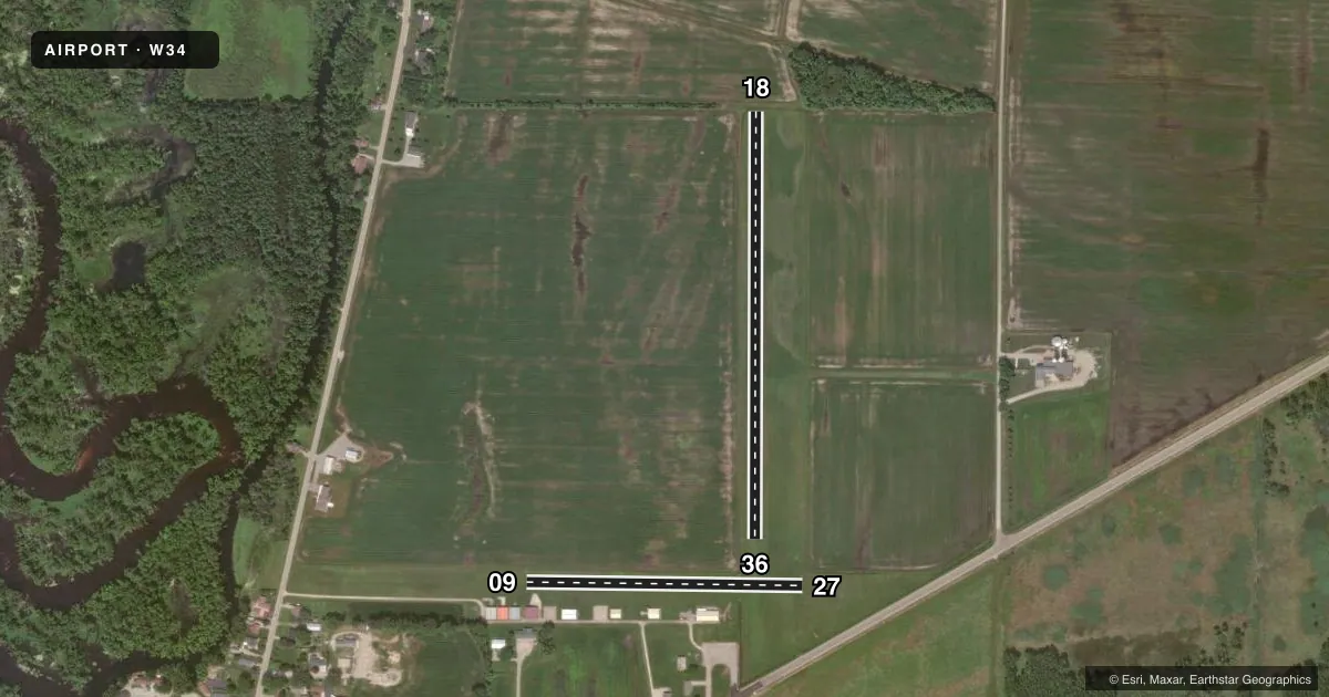
Full pagePattern entry · RWY 18
LEFT TRAFFIC| Runway | Heading (°M) | Length | Surface | Traffic |
|---|---|---|---|---|
| 18/36Favored | 179° / 359° | 2,159 ft | TURF | Standard L |
| 09/27 | 90° / 270° | 1,395 ft | TURF | Standard L |
Runway end performance
| End | TORA | TODA | ASDA | LDA | VGSI | Approach lights | Obstruction |
|---|---|---|---|---|---|---|---|
| 09 | — | — | — | — | — | — | 20', hangar, 50' from thr, 120' R of cntrln, slope 2 |
Declared distances in feet. TORA = takeoff run available, TODA = takeoff distance, ASDA = accelerate-stop, LDA = landing distance.
Airport sketch
Runways drawn to scale from FAA survey coordinates, rendered over satellite imagery. Not for navigation.
Approaches & charts
Services on the field
Fuel grades, oxygen, maintenance, ramp storage and lighting — as declared to the FAA by the airport operator.
Fuel & services
- Fuel
- Not available
- Other services
- INSTR
Ramp & ground
- Transient storage
- Tie-down
- Wind indicator
- Yes
- Segmented circle
- No
Fuel & FBOs
Cheapest 100LL and Jet A on the field and nearby. Always confirm with the FBO before taxi.
Airport notes
Surface conditions, obstructions, local procedures, lighting outages and other notes published with each FAA cycle.
General notes
- DEER & CRANES ON & INVOF ARPT.
- FOR CD CTC MINNEAPOLIS ARTCC AT 651-463-5588.
Lighting notes
- ULTRALIGHT ACT ON & INVOF ARPT.
Approach & departure obstructions
- 09MKD WITH ORANGE & WHITE BARRELS.
- 18MKD WITH ORANGE & WHITE BARRELS.
- 27MKD WITH ORANGE & WHITE BARRELS.
- 36MKD WITH ORANGE & WHITE BARRELS.
Other notes
- PRVDD THRS LCTD/DSPLCD TO PROVIDE 20:1 APCH SLOPE OVR ANY OBSTACLES IN APCH SFC AREAS.
- 1ARPT CLSD 15 MAR - 25 APR.
VFR map & nearby airports
VFR sectional. Tap any ICAO chip to open that airport.
Key facts · W34
Answer card- ICAO
- W34
- Name
- SHIOCTON
- Location
- SHIOCTON, WISCONSIN
- Elevation
- 760 ft MSL
- Traffic pattern altitude
- 1,760 ft MSL (1,000 AGL)
- Control tower
- Non-towered (use CTAF)
- Total runways
- 2
- Longest runway
- 18/36 · 2,159 ft
- Published ILS approaches
- 0
- Published frequencies
- 1
- Magnetic variation
- 1°
- Current flight rules
- VFR
- Current wind
- 180° at 4 kt
- Favored runway now
- RWY 18
Shiocton Airport sits in Shiocton, Wisconsin. Field elevation is 760 ft MSL. The airport has two turf runways. The longest is 18/36 at 2,159 ft. The other runway is 09/27 at 1,395 ft. No tower is published, so plan on CTAF self-announce work on 122.9.
No ILS approaches are published here. Pattern altitude is not published in the facts, so use the standard 1,000 ft AGL for light piston traffic unless the current Chart Supplement says otherwise. The field is closed from March 15 to April 25. That matters for spring planning.
The remarks also call out deer and cranes on and near the airport. Ultralight aircraft are active on and in the vicinity of the field. Thresholds are positioned or displaced to protect a 20:1 approach slope over obstacles. Runway 09, 27, 18 and 36 are marked with orange and white barrels. There are no on-field FBOs listed. Check with the airport operator or the field directly before you go. For clearance delivery, contact Minneapolis ARTCC at 651-463-5588. This is a turf airport with short runways. Verify surface condition, wildlife activity and seasonal closure before departure.