METAR & TAF 68C
68C does not publish a METAR.
Showing the nearest reporting station: KPCZ (WAUPACA MUNI) · 10.3 NM away. Conditions at 68C may differ.
METAR · KPCZ
Observed 12:15Z
KPCZ 271215Z AUTO 12003KT 5SM BR OVC005 25/24 A2978 RMK AO2 T02510238
- Wind
- 120° @ 3 kt
- Visibility
- 5 SM
- Temp / Dew
- 25°C / 24°C
- Altimeter
- 29.78 inHg
- Clouds
- OVC
- Density alt
- 2,467 ft
- Ceiling
- 500 ft AGL
- Rules
- IFR
Airport info & contacts
Manager on record, flight service, ARTCC, attendance schedule and pattern altitude — published by the FAA and refreshed every 28 days.
Location
- From city
- 4 NM E
- VFR sectional
- GREEN BAY
- ARTCC
- ZMP · MINNEAPOLIS
- NOTAM facility
- GRB (NOTAM-D)
Airport manager
- Name
- MARK HILDEBRAND
- Phone
- 920-572-0045
- Address
- E6597 PROGRESS RD, MANAWA WI 54949
Flight service · Hours
- FSS GRB
- GREEN BAY1-800-WX-BRIEF
- Attendance
- Unattended
Frequencies
Tap any row to copy the frequency to your clipboard.
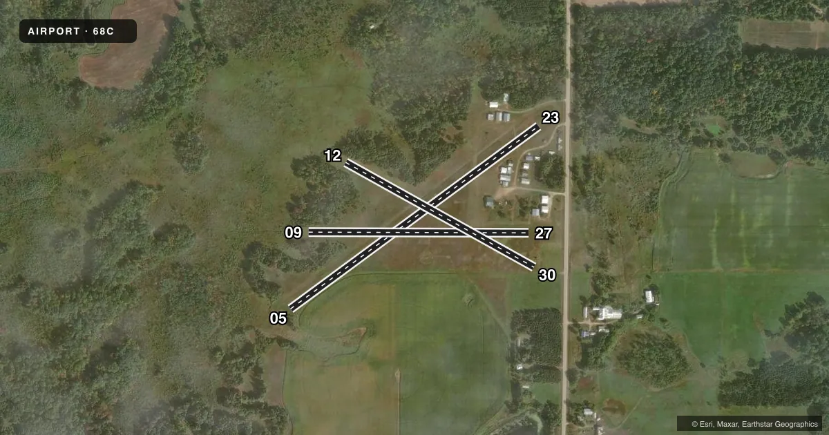
Runways & pattern
Full pagePattern entry · RWY 12
LEFT TRAFFIC| Runway | Heading (°M) | Length | Surface | Traffic |
|---|---|---|---|---|
| 05/23 | 53° / 233° | 2,493 ft | TURF | Standard L |
| 09/27 | 89° / 269° | 1,783 ft | TURF | Standard L |
| 12/30Favored | 118° / 298° | 1,745 ft | TURF | Standard L |
Runway end performance
| End | TORA | TODA | ASDA | LDA | VGSI | Approach lights | Obstruction |
|---|---|---|---|---|---|---|---|
| 05 | — | — | — | — | — | — | 38', trees, 75' from thr, 100' R of cntrln, slope 1 |
| 23 | — | — | — | — | — | — | 50', trees, 280' from thr, 150' R of cntrln, slope 5 |
| 09 | — | — | — | — | — | — | 57', trees, 0' from thr, 85' R of cntrln, slope 0 |
| 27 | — | — | — | — | — | — | 35', tree, 600' from thr, 0' R of cntrln, slope 17 |
| 12 | — | — | — | — | — | — | 50', trees, 10' from thr, 100' R of cntrln, slope 0 |
| 30 | — | — | — | — | — | — | 56', trees, 500' from thr, 160' R of cntrln, slope 8 |
Declared distances in feet. TORA = takeoff run available, TODA = takeoff distance, ASDA = accelerate-stop, LDA = landing distance.
Airport sketch
Runways drawn to scale from FAA survey coordinates, rendered over satellite imagery. Not for navigation.
Approaches & charts
Services on the field
Fuel grades, oxygen, maintenance, ramp storage and lighting — as declared to the FAA by the airport operator.
Fuel & services
- Fuel
- Not available
- Oxygen (bottled)
- Not available
- Oxygen (bulk)
- Not available
- Airframe repair
- Not available
- Power plant repair
- Not available
Ramp & ground
- Transient storage
- Tie-down
- Landing fee
- No fee published
- Wind indicator
- Yes
- Segmented circle
- Yes
Fuel & FBOs
Cheapest 100LL and Jet A on the field and nearby. Always confirm with the FBO before taxi.
Airport notes
Surface conditions, obstructions, local procedures, lighting outages and other notes published with each FAA cycle.
General notes
- ARPT CLSD TO WHEELED ACFT WHEN RYS COVERED WITH SNOW OR ICE.
- DEER ON & INVOF ARPT.
- FOR CD CTC MINNEAPOLIS ARTCC AT 651-463-5588.
- CAMPING AVBL.
Approach & departure obstructions
- 09MKD WITH ORANGE CONES.
- 09CTLG OBST EXCEEDS A 45 DEG SLP.
- 12CTLG OBST EXCEEDS A 45 DEG SLP.
Other notes
- EXISTED PRIOR TO 1959.
- MANAGERMARK57HILDEBRAND@YAHOO.COM.
VFR map & nearby airports
VFR sectional. Tap any ICAO chip to open that airport.
Key facts · 68C
Answer card- ICAO
- 68C
- Name
- CENTRAL COUNTY
- Location
- IOLA, WISCONSIN
- Elevation
- 882 ft MSL
- Traffic pattern altitude
- 1,882 ft MSL (1,000 AGL)
- Control tower
- Non-towered (use CTAF)
- Total runways
- 3
- Longest runway
- 05/23 · 2,493 ft
- Published ILS approaches
- 0
- Published frequencies
- 1
- Magnetic variation
- 1°
- Current flight rules
- IFR
- Current wind
- 120° at 3 kt
- Favored runway now
- RWY 12
Central County Airport sits in Iola, Wisconsin. Field elevation is 882 ft MSL. This is a small turf field with three runways. The longest is runway 05/23 at 2,493 ft. There is no control tower. CTAF is 122.9.
No ILS approaches are published here. Pattern altitude is not published, so use the standard 1,000 ft AGL for light piston traffic unless the current Chart Supplement says otherwise. The airport sits in a rural area. Deer are reported on and near the field. That matters here more than at a busy paved airport. Runway 09 is marked with orange cones. Published obstacles also exceed a 45 degree slope near runway 09. Obstacles exceed a 45 degree slope near runway 12 as well.
There are no on-field FBOs listed. Plan on confirming services with the airport operator before you go. Clearance delivery is handled through Minneapolis ARTCC at 651-463-5588. The airport is closed to wheeled aircraft when the runways are covered with snow or ice. Camping is available. If you are new to the field, treat the turf condition, deer activity and winter surface condition as the main operational items to check before departure.