METAR & TAF 92C
92C does not publish a METAR.
Showing the nearest reporting station: KGRB (GREEN BAY/AUSTIN STRAUBEL INTL) · 10.1 NM away. Conditions at 92C may differ.
METAR · KGRB
Observed 19:53Z
KGRB 261953Z 22005KT 10SM CLR 30/21 A2986 RMK AO2 SLP106 T03000206
- Wind
- 220° @ 5 kt
- Visibility
- 10 SM
- Temp / Dew
- 30°C / 21°C
- Altimeter
- 29.86 inHg
- Clouds
- CLR
- Density alt
- 2,845 ft
- Ceiling
- Unlimited
- Rules
- VFR
Airport info & contacts
Manager on record, flight service, ARTCC, attendance schedule and pattern altitude — published by the FAA and refreshed every 28 days.
Location
- From city
- 2 NM SSE
- VFR sectional
- GREEN BAY
- Pattern altitude
- 800 ft AGL · 1,583 ft MSL
- ARTCC
- ZMP · MINNEAPOLIS
- NOTAM facility
- GRB (NOTAM-D)
Airport manager
- Name
- BLUE SKIES AVIATION
- Phone
- 920-822-3644
- Address
- 3736 STATE ROAD 32, PULASKI WI 54162
Flight service · Hours
- FSS GRB
- GREEN BAY1-800-WX-BRIEF
- Attendance
- DALGT
Frequencies
Tap any row to copy the frequency to your clipboard.
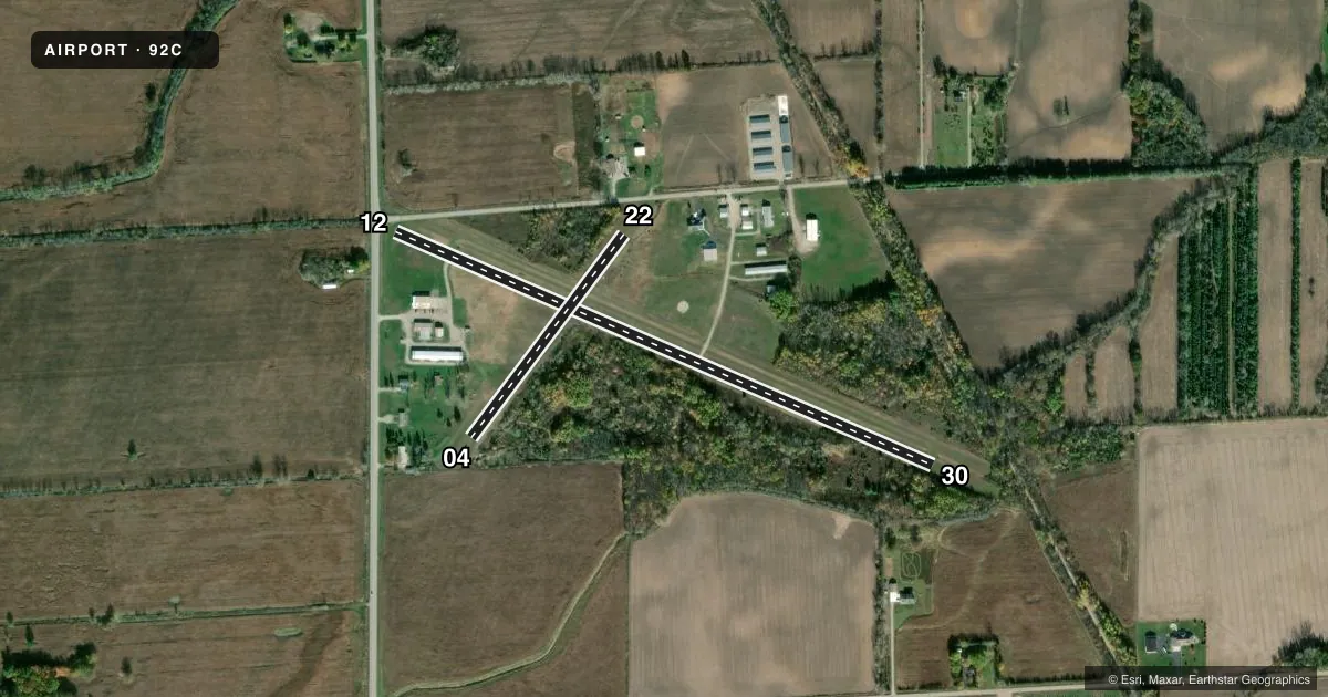
Runways & pattern
Full pagePattern entry · RWY 22
LEFT TRAFFIC| Runway | Heading (°M) | Length | Surface | Traffic |
|---|---|---|---|---|
| 12/30 | 112° / 292° | 2,955 ft | ASPH | Standard L |
| 04/22Favored | 35° / 215° | 1,281 ft | TURF | Standard L |
Runway end performance
| End | TORA | TODA | ASDA | LDA | VGSI | Approach lights | Obstruction |
|---|---|---|---|---|---|---|---|
| 12 | — | — | — | — | — | — | 35', trees, 200' from thr, 35' R of cntrln, slope 0 |
| 30 | — | — | — | — | — | — | 60', trees, 200' from thr, 125' R of cntrln, slope 0 |
| 04 | — | — | — | — | — | — | 50', tree, 50' from thr, 80' R of cntrln, slope 1 |
| 22 | — | — | — | — | — | — | 25', trees, 0' from thr, 95' R of cntrln, slope 0 |
Declared distances in feet. TORA = takeoff run available, TODA = takeoff distance, ASDA = accelerate-stop, LDA = landing distance.
Airport sketch
Runways drawn to scale from FAA survey coordinates, rendered over satellite imagery. Not for navigation.
Approaches & charts
Services on the field
Fuel grades, oxygen, maintenance, ramp storage and lighting — as declared to the FAA by the airport operator.
Fuel & services
- Fuel
- 100LLUL94
- Oxygen (bottled)
- Not available
- Oxygen (bulk)
- Not available
- Airframe repair
- Minor
- Power plant repair
- Minor
- Other services
- INSTR,PAJA
Ramp & ground
- Transient storage
- Tie-down
- Hangar
- Landing fee
- No fee published
- Customs
- Not available
- Lighting schedule
- SEE RMK
- Beacon schedule
- SEE RMK
- Beacon
- White / Green (civil land)(WG)
- Wind indicator
- Lighted
- Segmented circle
- Yes
Fuel & FBOs
Cheapest 100LL and Jet A on the field and nearby. Always confirm with the FBO before taxi.
Airport notes
Surface conditions, obstructions, local procedures, lighting outages and other notes published with each FAA cycle.
General notes
- PAJA ON ARPT.
- ULTRA-LIGHT FLYING ON & INVOF ARPT.
- LIMITED LINE-OF-SIGHT BETWEEN RWY 04 & 12; RWY 04 & 30.
- FOR CD CTC GREEN BAY APCH AT 920-431-5741, WHEN GREEN BAY APCH CLSD, FOR CD CTC MINNEAPOLIS ARTCC AT 651-463-5588.
Lighting notes
- ACTVT ROTG BCN , 3 CLICKS ON 5 CLICKS OFF - CTAF.
- ACTVT NSTD LIRL RY 12/30, 3 CLICKS ON 5 CLICKS OFF - CTAF.
Runway surface & condition
- 12/30RY 12/30 NSTD LIRL SPACED EVERY 300 FT. RY LIGHTED 2205 FT.
Approach & departure obstructions
- 1230 FT TREES 170 FT FM RWY END, 25 FT R; RD 0-70 FT FM RWY END, 60-0 FT L.
- 3050 FT TREES 0-200 FT FM RWY END, 100 FT L.
- 04CTLN OBSTN EXCEEDS A 45 DEG SLP.
- 12APCH RATIO 15:1 TO DSPLCD THR; 45 FT TREES 670 FT FM DSPLCD THR, 80 FT R.
- 30APCH RATIO 10:1 TO DSPLCD THR; 60 FT TREES 380 FT FM DSPLCD THR, 125 FT L.
Other notes
- MANAGEREMAIL ADDRESS: TEKO299@AOL.COM (ALL LOWER CASEE)
VFR map & nearby airports
VFR sectional. Tap any ICAO chip to open that airport.
Key facts · 92C
Answer card- ICAO
- 92C
- Name
- CARTER
- Location
- PULASKI, WISCONSIN
- Elevation
- 783 ft MSL
- Traffic pattern altitude
- 1,583 ft MSL (800 AGL)
- Control tower
- Non-towered (use CTAF)
- Total runways
- 2
- Longest runway
- 12/30 · 2,955 ft
- Published ILS approaches
- 0
- Published frequencies
- 4
- Magnetic variation
- 2°
- Current flight rules
- VFR
- Current wind
- 220° at 5 kt
- Favored runway now
- RWY 22
Carter Airport (92C) sits near Pulaski, Wisconsin. Field elevation is 783 ft MSL. The airport has two runways. The longest is 12/30 at 2,955 ft on asphalt. Runway 04/22 is a 1,281 ft turf strip. There is no control tower. Pattern altitude is 800 ft AGL, which is 1,583 ft MSL.
No ILS approaches are published here. Plan with the current chart and the Green Bay frequencies in mind. CTAF is 122.9. Green Bay Approach and Departure are used for IFR services. For clearance delivery, the published remarks say to contact Green Bay Approach. When Green Bay Approach is closed, contact Minneapolis ARTCC.
Blue Skies Aviation is on field. It carries 100LL and UL94. The field also has some operational details that matter on a first visit. Runway 12/30 has low intensity lights spaced every 300 ft. The runway is lighted for 2,205 ft. The rotating beacon uses 3 clicks on and 5 clicks off on CTAF. There are trees and road obstructions near runway ends. There is also parachute jumping activity and ultralight flying in the area. Line of sight is limited between runway 04 and 12 and between runway 04 and 30. Check the current Chart Supplement before you go. That is the best source for any updated operational notes.