METAR & TAF KOCQ
Current METAR
Observed 07:55Z
KOCQ 270755Z AUTO 00000KT 10SM CLR 26/20 A2973 RMK AO1 T02580202
- Wind
- 000° @ 0 kt
- Visibility
- 10 SM
- Temp / Dew
- 26°C / 20°C
- Altimeter
- 29.73 inHg
- Clouds
- CLR
- Density alt
- 2,305 ft
- Ceiling
- Unlimited
- Rules
- VFR
Airport info & contacts
Manager on record, flight service, ARTCC, attendance schedule and pattern altitude — published by the FAA and refreshed every 28 days.
Location
- From city
- 2 NM SW
- VFR sectional
- GREEN BAY
- ARTCC
- ZMP · MINNEAPOLIS
- NOTAM facility
- GRB (NOTAM-D)
Airport manager
- Name
- FRANK CALVERT
- Phone
- 920-834-7727
- Address
- 2983 AIRPORT RD, OCONTO WI 54153
Flight service · Hours
- FSS GRB
- GREEN BAY1-800-WX-BRIEF
- Attendance
- MON-FRI · IREG
Frequencies
Tap any row to copy the frequency to your clipboard.
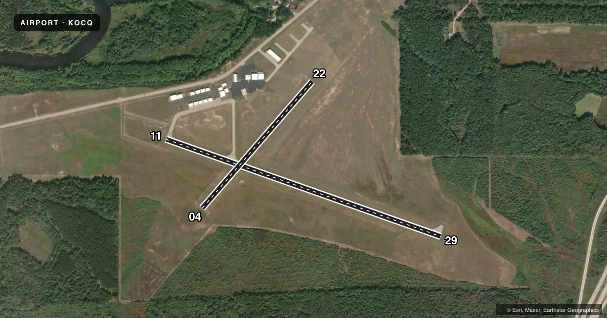
Runways & pattern
Full pagePattern entry · RWY 11
LEFT TRAFFIC| Runway | Heading (°M) | Length | Surface | Traffic |
|---|---|---|---|---|
| 11/29 | 106° / 286° | 3,199 ft | ASPH | Standard L |
| 04/22 | 38° / 218° | 1,840 ft | TURF | Standard L |
Runway end performance
| End | TORA | TODA | ASDA | LDA | VGSI | Approach lights | Obstruction |
|---|---|---|---|---|---|---|---|
| 11 | — | — | — | — | PAPI 2-box left(4°) | — | 41', trees, 940' from thr, 290' R of cntrln, slope 18 |
| 29 | — | — | — | — | PAPI 2-box left(4°) | — | — |
Declared distances in feet. TORA = takeoff run available, TODA = takeoff distance, ASDA = accelerate-stop, LDA = landing distance.
Airport sketch
Runways drawn to scale from FAA survey coordinates, rendered over satellite imagery. Not for navigation.
Approaches & charts
Services on the field
Fuel grades, oxygen, maintenance, ramp storage and lighting — as declared to the FAA by the airport operator.
Fuel & services
- Fuel
- 100LL
- Oxygen (bottled)
- Not available
- Oxygen (bulk)
- Not available
- Airframe repair
- Not available
- Power plant repair
- Not available
- Other services
- INSTR
Ramp & ground
- Transient storage
- Tie-down
- Hangar
- Landing fee
- No fee published
- Customs
- Not available
- Lighting schedule
- SEE RMK
- Beacon schedule
- SS-SR
- Beacon
- White / Green (civil land)(WG)
- Wind indicator
- Lighted
- Segmented circle
- Yes
Fuel & FBOs
Cheapest 100LL and Jet A on the field and nearby. Always confirm with the FBO before taxi.
Airport notes
Surface conditions, obstructions, local procedures, lighting outages and other notes published with each FAA cycle.
General notes
- CONFIRM WINTER RY CONDITIONS & SNOW REMOVAL WITH AMGR 920-834-7727.
- MIGRATORY WATERFOWL ON & INVOF ARPT.
- FOR CD CTC GREEN BAY APCH AT 920-431-5741, WHEN GREEN BAY APCH CLSD, FOR CD CTC MINNEAPOLIS ARTCC AT 651-463-5588.
Lighting notes
- MIRL RWY 11/29 PRESET TO LOW SS-SR; TO INCR INTST AND ACTVT REIL RWY 11 & 29; MIRL RWY 11/29 - CTAF. PAPI RWY 11 & 29 OPS CONSLY.
Fuel notes
- 100LL24 HR SELF SVC FUEL AVBL WITH CREDIT CARD.
Runway surface & condition
- 04/22NOT PLOWED NOV-APR.
Approach & departure obstructions
- 04MKD WITH WHITE CONES.
- 22MKD WITH WHITE CONES.
- 29RWY 29 PAPI UNUSBL BYD 8 DEGS RIGHT OF CNTRLN.
VFR map & nearby airports
VFR sectional. Tap any ICAO chip to open that airport.
Key facts · KOCQ
Answer card- ICAO
- KOCQ
- Name
- OCONTO/J DOUGLAS BAKE MUNI
- Location
- OCONTO, WISCONSIN
- Elevation
- 604.4 ft MSL
- Traffic pattern altitude
- 1,604.4 ft MSL (1,000 AGL)
- Control tower
- Non-towered (use CTAF)
- Total runways
- 2
- Longest runway
- 11/29 · 3,199 ft
- Published ILS approaches
- 0
- Published frequencies
- 4
- Magnetic variation
- 3°
- Current flight rules
- VFR
- Current wind
- 000° at 0 kt
- Favored runway now
- –
Oconto/J Douglas Bake Muni Airport is in Oconto, Wisconsin. The field elevation is 604.4 ft MSL. It has two runways. The longest is 11/29 at 3,199 ft, with 04/22 at 1,840 ft turf. There is no control tower. Pattern altitude is not published, so use the standard 1,000 ft AGL for light piston operations unless the current Chart Supplement says otherwise.
No ILS approaches are published here. CTAF and UNICOM are both 122.8. Green Bay Approach handles approach and departure on 120.3 or 338.2. The on-field FBO is Oconto Municipal Airport. It carries 100LL. Twenty-four hour self-serve 100LL is available with a credit card.
A few local items matter for planning. Runway 11/29 has medium intensity lights that are controlled by CTAF. Precision approach path indicators on 11 and 29 run continuously. Runway 29 has a PAPI limitation beyond 8 degrees right of centerline. Runways 04/22 are not plowed from November through April. Migratory waterfowl are reported on and near the airport, so expect bird activity. If you need clearance delivery, contact Green Bay Approach. If they are closed, use Minneapolis ARTCC. For winter operations, confirm runway condition and snow removal with the airport manager before you go.