METAR & TAF KUNU
Current METAR
Observed 12:38Z
KUNU 271238Z AUTO 16008KT 1 1/4SM BR OVC003 26/26 A2980 RMK AO2 T02560256 TSNO
- Wind
- 160° @ 8 kt
- Visibility
- 0.25 SM
- Temp / Dew
- 26°C / 26°C
- Altimeter
- 29.80 inHg
- Clouds
- OVC
- Density alt
- 2,627 ft
- Ceiling
- 300 ft AGL
- Rules
- LIFR
Airport info & contacts
Manager on record, flight service, ARTCC, attendance schedule and pattern altitude — published by the FAA and refreshed every 28 days.
Location
- From city
- 2 NM N
- VFR sectional
- CHICAGO
- ARTCC
- ZAU · CHICAGO
- NOTAM facility
- UNU (NOTAM-D)
Airport manager
- Name
- TOM DAVID
- Phone
- 920-386-2402
- Address
- W6491 STATE HIGHWAY 26, JUNEAU WI 53039
Flight service · Hours
- FSS GRB
- GREEN BAY1-800-WX-BRIEF
- Attendance
- 0700-1900
Frequencies
Tap any row to copy the frequency to your clipboard.
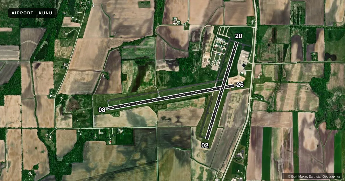
Runways & pattern
Full pagePattern entry · RWY 20
LEFT TRAFFIC| Runway | Heading (°M) | Length | Surface | Traffic |
|---|---|---|---|---|
| 08/26 | 79° / 259° | 5,070 ft | ASPH | Standard L |
| 02/20Favored | 16° / 196° | 4,028 ft | ASPH | Standard L |
Runway end performance
| End | TORA | TODA | ASDA | LDA | VGSI | Approach lights | Obstruction |
|---|---|---|---|---|---|---|---|
| 08 | — | — | — | — | PAPI 4-box left(3°) | — | 146', trees, 4300' from thr, 400' R of cntrln, slope 28 |
| 26 | — | — | — | — | PAPI 4-box left(3°) | MALSF | — |
| 02 | — | — | — | — | PAPI 2-box left(3°) | — | — |
| 20 | — | — | — | — | PAPI 2-box left(3°) | — | — |
Declared distances in feet. TORA = takeoff run available, TODA = takeoff distance, ASDA = accelerate-stop, LDA = landing distance.
Airport sketch
Runways drawn to scale from FAA survey coordinates, rendered over satellite imagery. Not for navigation.
Approaches & charts
Services on the field
Fuel grades, oxygen, maintenance, ramp storage and lighting — as declared to the FAA by the airport operator.
Fuel & services
- Fuel
- 100LLA+
- Oxygen (bottled)
- Not available
- Oxygen (bulk)
- Not available
- Airframe repair
- Major
- Power plant repair
- Major
- Other services
- CHTR,INSTR,RNTL,SALES
Ramp & ground
- Transient storage
- Tie-down
- Hangar
- Landing fee
- No fee published
- Customs
- Not available
- Lighting schedule
- SEE RMK
- Beacon schedule
- SS-SR
- Beacon
- White / Green (civil land)(WG)
- Wind indicator
- Lighted
- Segmented circle
- Yes
Fuel & FBOs
Cheapest 100LL and Jet A on the field and nearby. Always confirm with the FBO before taxi.
Airport notes
Surface conditions, obstructions, local procedures, lighting outages and other notes published with each FAA cycle.
General notes
- IREG ULTRALIGHT ACTIVITY ON & INVOF ARPT.
- BIRDS ON & INVOF ARPT.
- MOWING OPNS MON-FRI WITH FLASHING LGTS AFT DARK.
- FOR CD CTC MADISON APP/DEP CON AT 608-249-8240. WHEN MADISON APCH CLSD, FOR CD CTC CHICAGO ARTCC AT 630-906-8921.
Lighting notes
- MIRL RWY 08/26 PRESET ON LOW SS-SR; TO INCR INTST & ACTVT MALSF RWY 26; REIL RWY 02, 08 & 20; PAPI RWY 02, 08, 20 & 26; MIRL RWY 02/20; MIRL RWY 08/26 - CTAF.
VFR map & nearby airports
VFR sectional. Tap any ICAO chip to open that airport.
Key facts · KUNU
Answer card- ICAO
- KUNU
- Name
- DODGE COUNTY
- Location
- JUNEAU, WISCONSIN
- Elevation
- 934.1 ft MSL
- Traffic pattern altitude
- 1,934.1 ft MSL (1,000 AGL)
- Control tower
- Non-towered (use CTAF)
- Total runways
- 2
- Longest runway
- 08/26 · 5,070 ft
- Published ILS approaches
- 0
- Published frequencies
- 4
- Magnetic variation
- 1°
- Current flight rules
- LIFR
- Current wind
- 160° at 8 kt
- Favored runway now
- RWY 20
Dodge County Airport sits in Juneau, Wisconsin. The field elevation is 934.1 ft MSL. It has two asphalt runways. The longest is 5,070 ft on runway 08/26. There is no control tower. Traffic pattern altitude is not published, so use the standard 1,000 ft AGL for light piston operations unless current guidance says otherwise.
No ILS approaches are published here. If you are planning an instrument arrival, check the current approach setup before you launch. Wisconsin Aviation is on the field. It carries 100LL, Jet A and Jet A Prist. Call (920) 386-2402 for current service details.
Runway lighting is pilot-controlled by CTAF. Runway 08/26 is preset low from sunset to sunrise. To increase intensity and activate the MALSR on runway 26, use CTAF. REILs are on runways 02, 08 and 20. PAPI is on runways 02, 08, 20 and 26.
First-time visitors should also plan for irregular ultralight activity on and near the airport. Birds are present too. Mowing operations happen Monday through Friday with flashing lights after dark. For IFR clearance delivery, Madison Approach handles it when open. If Madison is closed, Chicago ARTCC handles clearance delivery. Check current procedures before departure.