METAR & TAF 61C
61C does not publish a METAR.
Showing the nearest reporting station: KRYV (WATERTOWN MUNI) · 13.1 NM away. Conditions at 61C may differ.
METAR · KRYV
Observed 04:35Z
KRYV 270435Z AUTO 00000KT 10SM CLR 23/23 A2983 RMK AO2 T02300230
- Wind
- 000° @ 0 kt
- Visibility
- 10 SM
- Temp / Dew
- 23°C / 23°C
- Altimeter
- 29.83 inHg
- Clouds
- CLR
- Density alt
- 2,064 ft
- Ceiling
- Unlimited
- Rules
- VFR
Airport info & contacts
Manager on record, flight service, ARTCC, attendance schedule and pattern altitude — published by the FAA and refreshed every 28 days.
Location
- From city
- 3 NM NE
- VFR sectional
- CHICAGO
- ARTCC
- ZAU · CHICAGO
- NOTAM facility
- GRB (NOTAM-D)
Airport manager
- Name
- JEDIDIAH DRAEGER
- Phone
- 920-397-9901
- Address
- 101 N MAIN ST, FORT ATKINSON WI 53538
Flight service · Hours
- FSS GRB
- GREEN BAY1-800-WX-BRIEF
- Attendance
- Unattended
Frequencies
Tap any row to copy the frequency to your clipboard.
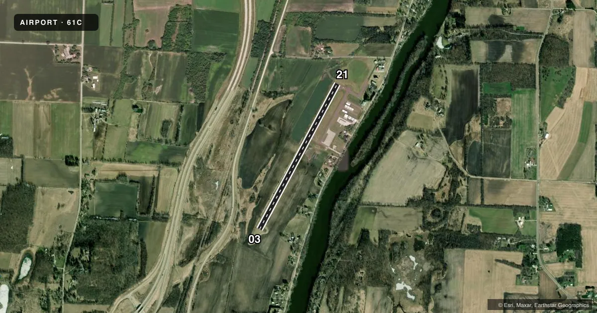
Runways & pattern
Full pagePattern entry · RWY 03
LEFT TRAFFICRunway end performance
| End | TORA | TODA | ASDA | LDA | VGSI | Approach lights | Obstruction |
|---|---|---|---|---|---|---|---|
| 03 | — | — | — | — | PAPI 2-box left(3°) | — | — |
| 21 | — | — | — | — | PAPI 2-box left(3°) | — | 10', brush, 220' from thr, 120' R of cntrln, slope 2 |
Declared distances in feet. TORA = takeoff run available, TODA = takeoff distance, ASDA = accelerate-stop, LDA = landing distance.
Airport sketch
Runways drawn to scale from FAA survey coordinates, rendered over satellite imagery. Not for navigation.
Approaches & charts
Services on the field
Fuel grades, oxygen, maintenance, ramp storage and lighting — as declared to the FAA by the airport operator.
Fuel & services
- Fuel
- 100LLA+
- Oxygen (bottled)
- Not available
- Oxygen (bulk)
- Not available
- Airframe repair
- Not available
- Power plant repair
- Not available
- Other services
- PAJA
Ramp & ground
- Transient storage
- Tie-down
- Landing fee
- No fee published
- Lighting schedule
- SEE RMK
- Beacon schedule
- SS-SR
- Beacon
- White / Green (civil land)(WG)
- Wind indicator
- Lighted
- Segmented circle
- Yes
Fuel & FBOs
Cheapest 100LL and Jet A on the field and nearby. Always confirm with the FBO before taxi.
Airport notes
Surface conditions, obstructions, local procedures, lighting outages and other notes published with each FAA cycle.
General notes
- RY 03/21 PILOTS REQUESTED TO FLY RY HEADING & CLIMB TO 1400 FT MSL BEFORE TURNING EAST.
- ULTRALIGHT ACTVTY ON & IN VCNTY OF ARPT.
- FOR CD CTC MADISON APP/DEP CON AT 608-249-8240. WHEN MADISON APCH CLSD, FOR CD CTC CHICAGO ARTCC AT 630-906-8921.
Lighting notes
- MIRL RWY 03/21 PRESET TO LOW SS-SR; TO INCR INTST & ACTVT PAPI RWY 03 & 21; MIRL RWY 03/21 - CTAF.
Fuel notes
- 100LL24 HR SELF SVC FUEL AVBL WITH CREDIT CARD.
Approach & departure obstructions
- 0310 FT BRUSH 30 FT FM THR; 100 FT L.
- 2110 FT BRUSH 100 FT FM THR; 115 FT R.
Other notes
- CONSTR PRIOR TO 1959
- MANAGEREMAIL ADDRESS: JDRAEGER@FORTATKINSONWI.GOV
VFR map & nearby airports
VFR sectional. Tap any ICAO chip to open that airport.
Key facts · 61C
Answer card- ICAO
- 61C
- Name
- FORT ATKINSON MUNI
- Location
- FORT ATKINSON, WISCONSIN
- Elevation
- 800.1 ft MSL
- Traffic pattern altitude
- 1,800.1 ft MSL (1,000 AGL)
- Control tower
- Non-towered (use CTAF)
- Total runways
- 1
- Longest runway
- 03/21 · 3,800 ft
- Published ILS approaches
- 0
- Published frequencies
- 3
- Magnetic variation
- 2°
- Current flight rules
- VFR
- Current wind
- 000° at 0 kt
- Favored runway now
- –
Fort Atkinson Muni sits in Fort Atkinson, Wisconsin. Field elevation is 800.1 ft MSL. The airport has one runway. Runway 03/21 is 3,800 ft asphalt, which is the longest runway on the field. There is no control tower. CTAF is 122.9. Madison Approach and Departure use 120.1 and 350.3 for the area.
No ILS approaches are published here. Pattern altitude is not published in the Chart Supplement, so light piston traffic should use the standard 1,000 ft AGL unless local instructions say otherwise. That puts the pattern at about 1,800 ft MSL. The published remarks matter here. Runway lights on 03/21 are preset low from sunset to sunrise. Use CTAF to increase intensity and to activate the PAPI on 03 and 21. There is also 24-hour self-serve 100LL with credit card.
First-time arrivals should pay attention to the runway-end brush. There is brush near both thresholds on 03/21. Ultralight activity also occurs on and near the airport. For runway 03/21, pilots are asked to fly runway heading and climb to 1,400 ft MSL before turning east. If you need a clearance, contact Madison Approach/Departure Control. If they are closed, use Chicago ARTCC. No on-field FBOs are listed.