METAR & TAF KRYV
Current METAR
Observed 15:50Z
KRYV 271550Z AUTO 17011G15KT 7SM -TSRA BKN019 BKN025 OVC055 26/26 A2969 RMK AO2 LTG DSNT ALQS P0005 T02620262
- Wind
- 170° @ 11G15 kt
- Visibility
- 7 SM
- Temp / Dew
- 26°C / 26°C
- Altimeter
- 29.69 inHg
- Clouds
- OVC
- Density alt
- 2,638 ft
- Ceiling
- 1,900 ft AGL
- Rules
- MVFR
Airport info & contacts
Manager on record, flight service, ARTCC, attendance schedule and pattern altitude — published by the FAA and refreshed every 28 days.
Location
- From city
- 0 NM S
- VFR sectional
- CHICAGO
- ARTCC
- ZAU · CHICAGO
- NOTAM facility
- RYV (NOTAM-D)
Airport manager
- Name
- JEFF BAUM
- Phone
- 920-261-4567
- Address
- 1741 RIVER DRIVE, WATERTOWN WI 53094
Flight service · Hours
- FSS GRB
- GREEN BAY1-800-WX-BRIEF
- Attendance
- MON-FRI · 0600-2000
- SAT-SUN · 0700-2000
Frequencies
Tap any row to copy the frequency to your clipboard.
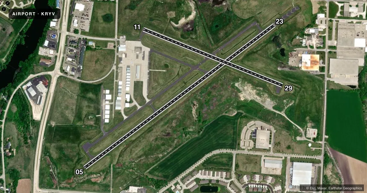
Runways & pattern
Full pagePattern entry · RWY 11
RIGHT TRAFFIC| Runway | Heading (°M) | Length | Surface | Traffic |
|---|---|---|---|---|
| 05/23 | 52° / 232° | 4,429 ft | ASPH | 05 R |
| 11/29Favored | 111° / 291° | 2,801 ft | ASPH | 11 R |
Runway end performance
| End | TORA | TODA | ASDA | LDA | VGSI | Approach lights | Obstruction |
|---|---|---|---|---|---|---|---|
| 05 | 4,430' | 5,110' | 4,550' | 4,430' | PAPI 2-box left(3°) | — | 20', brush, 280' from thr, 70' R of cntrln, slope 4 |
| 23 | 4,430' | 4,845' | 4,430' | 4,430' | PAPI 2-box left(3°) | — | 76', tree, 1450' from thr, 400' R of cntrln, slope 16 |
| 11 | — | — | — | — | — | — | 42', trees, 900' from thr, 225' R of cntrln, slope 16 |
| 29 | — | — | — | — | — | — | 64', tree, 1100' from thr, 350' R of cntrln, slope 14 |
Declared distances in feet. TORA = takeoff run available, TODA = takeoff distance, ASDA = accelerate-stop, LDA = landing distance.
Airport sketch
Runways drawn to scale from FAA survey coordinates, rendered over satellite imagery. Not for navigation.
Approaches & charts
Services on the field
Fuel grades, oxygen, maintenance, ramp storage and lighting — as declared to the FAA by the airport operator.
Fuel & services
- Fuel
- 100LLA+
- Oxygen (bulk)
- Low pressure
- Airframe repair
- Major
- Power plant repair
- Major
- Other services
- CHTR,INSTR,RNTL,SALES
Ramp & ground
- Transient storage
- Tie-down
- Hangar
- Landing fee
- No fee published
- Customs
- Not available
- Lighting schedule
- SEE RMK
- Beacon schedule
- SS-SR
- Beacon
- White / Green (civil land)(WG)
- Wind indicator
- Lighted
- Segmented circle
- Yes
Fuel & FBOs
Cheapest 100LL and Jet A on the field and nearby. Always confirm with the FBO before taxi.
Airport notes
Surface conditions, obstructions, local procedures, lighting outages and other notes published with each FAA cycle.
General notes
- DEER ON & INVOF ARPT.
- DUCKS & SEAGULLS OCCASSIONALLY NEAR ARPT DURING SEASONAL MIGRATIONS.
- FOR CD CTC MADISON APP/DEP CON AT 608-249-8240. WHEN MADISON APCH CLSD, FOR CD CTC CHICAGO ARTCC AT 630-906-8921.
Lighting notes
- MIRL RWY 05/23 PRESET TO LOW SS-SR; TO INCR INTST & ACTVT REIL RWY 05 & 23; PAPI RWY 05 & 23; MIRL RWY 05/23; MIRL RWY 11/29 - CTAF.
Approach & departure obstructions
- 05APCH RATIO 23:1 TO DSPLCD THR.
Other notes
- THIS AIRPORT HAS BEEN SURVEYED BY THE NATIONAL GEODETIC SURVEY.
- 1ARPT ATTENDED OTHER HRS ON REQUEST THRU FBO.
VFR map & nearby airports
VFR sectional. Tap any ICAO chip to open that airport.
Key facts · KRYV
Answer card- ICAO
- KRYV
- Name
- WATERTOWN MUNI
- Location
- WATERTOWN, WISCONSIN
- Elevation
- 832.9 ft MSL
- Traffic pattern altitude
- 1,832.9 ft MSL (1,000 AGL)
- Control tower
- Non-towered (use CTAF)
- Total runways
- 2
- Longest runway
- 05/23 · 4,429 ft
- Published ILS approaches
- 0
- Published frequencies
- 4
- Magnetic variation
- 1°
- Current flight rules
- MVFR
- Current wind
- 170° at 11 kt
- Favored runway now
- RWY 11
Watertown Muni sits in Watertown, Wisconsin. Field elevation is 832.9 ft MSL. The airport has two asphalt runways. The longest is 4,429 ft on 05/23. There is no control tower. CTAF and UNICOM are both 122.8. No ILS approaches are published here.
Pattern altitude is not published. Use standard 1,000 ft AGL for light piston traffic unless the current Chart Supplement says otherwise. Wisconsin Aviation is on the field. It carries 100LL, Jet A and Jet A Prist. Call (920) 261-4567 for current service details before arrival.
A few items matter for the first visit. Runway 05/23 has medium intensity lighting that is preset low from sunset to sunrise. Use CTAF to raise the intensity and activate the runway end identifier lights. PAPI is installed on 05 and 23. Runway 05 has a published displaced-threshold note, so plan your approach carefully. Deer are reported on and near the airport. Ducks and seagulls can also show up during seasonal migration. If you need clearance delivery, contact Madison Approach/Departure Control. If Madison is closed, use Chicago ARTCC. The field is unattended at some hours. It can be attended on request through the FBO.