METAR & TAF 87Y
87Y does not publish a METAR.
Showing the nearest reporting station: KMSN (DANE COUNTY RGNL/TRUAX FLD) · 7.0 NM away. Conditions at 87Y may differ.
METAR · KMSN
Observed 15:53Z
KMSN 271553Z 23007G15KT 10SM FEW018 FEW080 32/26 A2966 RMK AO2 LTG DSNT NE AND E SLP034 T03170256
- Wind
- 230° @ 7G15 kt
- Visibility
- 10 SM
- Temp / Dew
- 32°C / 26°C
- Altimeter
- 29.66 inHg
- Clouds
- FEW
- Density alt
- 3,503 ft
- Ceiling
- Unlimited
- Rules
- VFR
Airport info & contacts
Manager on record, flight service, ARTCC, attendance schedule and pattern altitude — published by the FAA and refreshed every 28 days.
Location
- From city
- 10 NM E
- VFR sectional
- CHICAGO
- ARTCC
- ZAU · CHICAGO
- NOTAM facility
- GRB (NOTAM-D)
Airport manager
- Name
- CHERYL STRASSMAN
- Phone
- (608) 334-4932
- Address
- 2534 S FISH HATCHERY ROAD, FITCHBURG WI 53711
Flight service · Hours
- FSS GRB
- GREEN BAY1-800-WX-BRIEF
- Attendance
- UNATTND
Frequencies
Tap any row to copy the frequency to your clipboard.
Runways & pattern
Full pagePattern entry · RWY 22
LEFT TRAFFIC| Runway | Heading (°M) | Length | Surface | Traffic |
|---|---|---|---|---|
| 04/22Favored | 37° / 217° | 2,814 ft | ASPH | 04 R |
| 09/27 | 86° / 267° | 2,150 ft | ASPH | 27 R |
Runway end performance
| End | TORA | TODA | ASDA | LDA | VGSI | Approach lights | Obstruction |
|---|---|---|---|---|---|---|---|
| 04 | — | — | — | — | — | — | 40', trees, 265' from thr, 55' R of cntrln, slope 1 |
| 22 | — | — | — | — | — | — | 48', trees, 210' from thr, 25' R of cntrln, slope 1 |
| 09 | — | — | — | — | — | — | 15', road, 210' from thr, 0' R of cntrln, slope 1 |
| 27 | — | — | — | — | — | — | 16', road, 317' from thr, 0' R of cntrln, slope 7 |
Declared distances in feet. TORA = takeoff run available, TODA = takeoff distance, ASDA = accelerate-stop, LDA = landing distance.
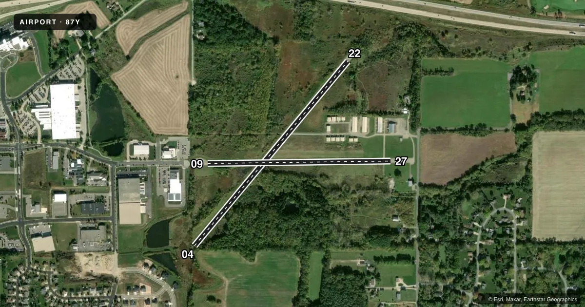
Airport sketch
Runways drawn to scale from FAA survey coordinates, rendered over satellite imagery. Not for navigation.
Approaches & charts
Services on the field
Fuel grades, oxygen, maintenance, ramp storage and lighting — as declared to the FAA by the airport operator.
Fuel & services
- Fuel
- Not available
- Oxygen (bottled)
- Not available
- Oxygen (bulk)
- Not available
- Airframe repair
- Not available
- Power plant repair
- Not available
Ramp & ground
- Transient storage
- Tie-down
- Hangar
- Landing fee
- No fee published
- Lighting schedule
- SS-SR
- Beacon schedule
- SS-SR
- Beacon
- White / Green (civil land)(WG)
- Wind indicator
- No
- Segmented circle
- Yes
Fuel & FBOs
Cheapest 100LL and Jet A on the field and nearby. Always confirm with the FBO before taxi.
Airport notes
Surface conditions, obstructions, local procedures, lighting outages and other notes published with each FAA cycle.
General notes
- RWY 09 AVOID OVERFLIGHT OF FARM 3/4 MI EAST.
- DEER & TURKEYS ON & INVOF ARPT.
- RWY ENDS OBSTD VISUALLY FM OTRS.
- FOR CD CTC MADISON APP/DEP CON AT 608-249-8240. WHEN MADISON APCH CLSD, FOR CD CTC CHICAGO ARTCC AT 630-906-8921.
- COLD TEMPERATURE AIRPORT. ALTITUDE CORRECTION REQUIRED AT OR BELOW -23C.
Runway surface & condition
- 09/27NSTD LIRL; RWY LGTS 2 FT TO 3 FT ABOVE RWY & NSTD SPACING. RWY 09/27 LGTD 1970 FT.
Approach & departure obstructions
- 0435 FT TREE 45 FT FM THR, 50 FT R.
- 0940 FT TREES 180 FT FM THR, 100 FT L.
- 2245 FT TREES 160 FT FM THR, 25L.
- 04MARKINGS FADED.
- 09MARKINGS FADED.
- 22MARKINGS FADED.
- 27MARKINGS FADED.
- 22APCH RATIO 10:1 TO DTHR. 48 FT TREES 470 FT FM DTHR, 25 FT L.
- 27APCH RATIO 20:1 TO DTHR.
Other notes
- MANAGEREMAIL ADDRESS: STRASS32@AMERITECH.NET (ALL LOWER CASE)
- 04/22CRACKS WITH VEGETATION.
VFR map & nearby airports
VFR sectional. Tap any ICAO chip to open that airport.
Key facts · 87Y
Answer card- ICAO
- 87Y
- Name
- BLACKHAWK AIRFIELD
- Location
- MADISON, WISCONSIN
- Elevation
- 920 ft MSL
- Traffic pattern altitude
- 1,920 ft MSL (1,000 AGL)
- Control tower
- Non-towered (use CTAF)
- Total runways
- 2
- Longest runway
- 04/22 · 2,814 ft
- Published ILS approaches
- 0
- Published frequencies
- 4
- Magnetic variation
- 3°
- Current flight rules
- VFR
- Current wind
- 230° at 7 kt
- Favored runway now
- RWY 22
Blackhawk Airfield sits in Madison, Wisconsin. Field elevation is 920 ft MSL. It has two asphalt runways. The longest is runway 04/22 at 2,814 ft. Runway 09/27 is 2,150 ft. There is no control tower. No ILS approaches are published. Pattern altitude is not published. Use the standard 1,000 ft AGL pattern unless local procedures say otherwise.
This is a cold temperature airport. Altitude correction is required at or below minus 23 degrees Celsius. That matters here in winter. Runway markings on 04, 22 and 27 are faded. Runway 22 has a displaced threshold with trees close in the approach path. Runway 09 also has trees near the threshold. Runway 04 has a tree close to the threshold on the right side. Runway ends are obstructed visually from other positions, so a careful look at the runway environment helps on arrival and departure.
No on-field FBOs are listed. Contact the airport operator directly before arrival. Call the field on CTAF or UNICOM for current FBO availability. For clearance delivery, Madison Approach/Departure Control handles it when open. If they are closed, use Chicago ARTCC. Deer and turkeys are reported on and near the airport. Avoid overflight of the farm three quarters of a mile east of runway 09.