METAR & TAF 94C
94C does not publish a METAR.
Showing the nearest reporting station: KMSN (DANE COUNTY RGNL/TRUAX FLD) · 19.1 NM away. Conditions at 94C may differ.
METAR · KMSN
Observed 16:53Z
KMSN 271653Z VRB06KT 10SM FEW025 BKN085 BKN250 33/26 A2966 RMK AO2 SLP034 T03330256
- Wind
- VAR @ 6 kt
- Visibility
- 10 SM
- Temp / Dew
- 33°C / 26°C
- Altimeter
- 29.66 inHg
- Clouds
- BKN
- Density alt
- 3,632 ft
- Ceiling
- 8,500 ft AGL
- Rules
- VFR
Airport info & contacts
Manager on record, flight service, ARTCC, attendance schedule and pattern altitude — published by the FAA and refreshed every 28 days.
Location
- From city
- 1 NM W
- VFR sectional
- CHICAGO
- ARTCC
- ZAU · CHICAGO
- NOTAM facility
- GRB (NOTAM-D)
Airport manager
- Name
- RIO CLUB CLUB INC
- Phone
- 920-214-5917
- Address
- 5019 HWY 116, RIO WI 53960
Flight service · Hours
- FSS GRB
- GREEN BAY1-800-WX-BRIEF
- Attendance
- Unattended
Frequencies
Tap any row to copy the frequency to your clipboard.
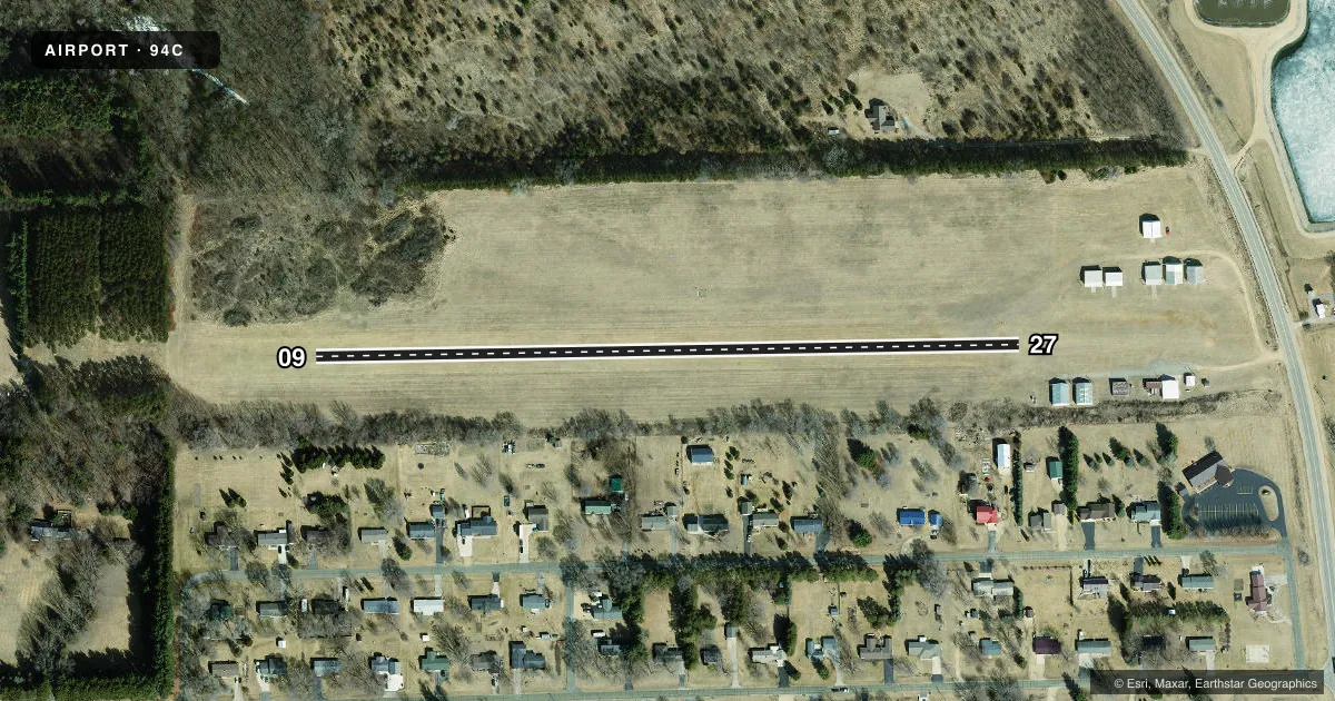
Runways & pattern
Full pagePattern entry · RWY 09
LEFT TRAFFICRunway end performance
| End | TORA | TODA | ASDA | LDA | VGSI | Approach lights | Obstruction |
|---|---|---|---|---|---|---|---|
| 09 | — | — | — | — | — | — | 78', trees, 400' from thr, 140' R of cntrln, slope 5 |
| 27 | — | — | — | — | — | — | 20', hangar, 100' from thr, 100' R of cntrln, slope 5 |
Declared distances in feet. TORA = takeoff run available, TODA = takeoff distance, ASDA = accelerate-stop, LDA = landing distance.
Airport sketch
Runways drawn to scale from FAA survey coordinates, rendered over satellite imagery. Not for navigation.
Approaches & charts
Services on the field
Fuel grades, oxygen, maintenance, ramp storage and lighting — as declared to the FAA by the airport operator.
Fuel & services
- Fuel
- Not available
- Oxygen (bottled)
- Not available
- Oxygen (bulk)
- Not available
- Airframe repair
- Not available
- Power plant repair
- Not available
Ramp & ground
- Transient storage
- Tie-down
- Landing fee
- No fee published
- Wind indicator
- Yes
- Segmented circle
- No
Fuel & FBOs
Cheapest 100LL and Jet A on the field and nearby. Always confirm with the FBO before taxi.
Airport notes
Surface conditions, obstructions, local procedures, lighting outages and other notes published with each FAA cycle.
General notes
- CFM WINTER RWY CONDS & SN REMOVAL CALL 920-214-5917.
- FOR CD CTC MADISON APP/DEP CON AT 608-249-8240. WHEN MADISON APCH CLSD, FOR CD CTC CHICAGO ARTCC AT 630-906-8921.
- WILDLIFE ON & INVOF ARPT.
- RWY 09/27 STEEP DROP OFF AT RWY EDGE AND RWY 09 APCH END.
Approach & departure obstructions
- 09MKD WITH ORANGE CONES.
- 27MKD WITH ORANGE CONES.
- 09MKD WITH YELLOW CONES.
- 27MKD WITH YELLOW CONES.
- 09APCH RATIO 11:1 TO DTHR. 78 FT TREES 840 FT FM DTHR, 140 FT L.
- 27APCH RATIO 14:1 TO DTHR. 20 FT HNGR 275 FT FM DTHR, 100 FT L.
Other notes
- ESTABLISHED PRIOR TO 1959.
- MANAGERROATAVIATION@GMAIL.COM.
VFR map & nearby airports
VFR sectional. Tap any ICAO chip to open that airport.
Key facts · 94C
Answer card- ICAO
- 94C
- Name
- GILBERT FLD
- Location
- RIO, WISCONSIN
- Elevation
- 927 ft MSL
- Traffic pattern altitude
- 1,927 ft MSL (1,000 AGL)
- Control tower
- Non-towered (use CTAF)
- Total runways
- 1
- Longest runway
- 09/27 · 1,800 ft
- Published ILS approaches
- 0
- Published frequencies
- 1
- Magnetic variation
- 0°
- Current flight rules
- VFR
- Current wind
- 000° at 6 kt
- Favored runway now
- RWY 09
GILBERT FLD is in Rio, Wisconsin. Field elevation is 927 ft MSL. It has one runway, 09/27, which is 1,800 ft long and turf. There is no control tower. CTAF is 122.9. No ILS approaches are published here.
Pattern altitude is not published in the facts, so use the standard 1,000 ft AGL unless the current Chart Supplement says otherwise. With a 927 ft field elevation, that is 1,927 ft MSL for a normal light-piston pattern. The airport sits in a rural area with wildlife reported on and near the field. Runway 09/27 also has a steep drop off at the runway edge. The approach end of runway 09 has a steep drop off too.
Published remarks also show displaced thresholds on both ends. Runway 09 has yellow cones. Runway 27 has yellow cones too. Orange cones mark the displaced thresholds. The approach to runway 09 has tree clearance issues near the threshold. The approach to runway 27 has a hangar close to the displaced threshold. There are no on-field FBOs listed, so call the airport manager or the airport operator before arrival if you need local field conditions. For winter operations, confirm runway condition and snow removal before you go. Clearance delivery is handled through Madison Approach or Chicago ARTCC when needed.