METAR & TAF KDLL
Current METAR
Observed 18:35Z
KDLL 261835Z AUTO 20007KT 10SM SCT033 SCT041 31/22 A2989 RMK AO2 T03100224
- Wind
- 200° @ 7 kt
- Visibility
- 10 SM
- Temp / Dew
- 31°C / 22°C
- Altimeter
- 29.89 inHg
- Clouds
- SCT
- Density alt
- 3,173 ft
- Ceiling
- Unlimited
- Rules
- VFR
Airport info & contacts
Manager on record, flight service, ARTCC, attendance schedule and pattern altitude — published by the FAA and refreshed every 28 days.
Location
- From city
- 3 NM NW
- VFR sectional
- CHICAGO
- ARTCC
- ZAU · CHICAGO
- NOTAM facility
- DLL (NOTAM-D)
Airport manager
- Name
- TIM MCCUMBER
- Phone
- 608-254-2558
- Address
- PO BOX 50, LAKE DELTON WI 53940
Flight service · Hours
- FSS GRB
- GREEN BAY1-800-WX-BRIEF
- Attendance
- MAY-SEP · 0800-1900
- OCT-APR · 0800-1700
Frequencies
Tap any row to copy the frequency to your clipboard.
Runways & pattern
Full pagePattern entry · RWY 19
LEFT TRAFFIC| Runway | Heading (°M) | Length | Surface | Traffic |
|---|---|---|---|---|
| 01/19Favored | 8° / 188° | 5,010 ft | ASPH | Standard L |
| 14/32 | 133° / 313° | 2,725 ft | TURF | Standard L |
Runway end performance
| End | TORA | TODA | ASDA | LDA | VGSI | Approach lights | Obstruction |
|---|---|---|---|---|---|---|---|
| 01 | — | — | — | — | PAPI 2-box left(3°) | — | — |
| 19 | — | — | — | — | PAPI 2-box left(3°) | — | 50', trees, 1555' from thr, 290' R of cntrln, slope 27 |
| 14 | — | — | — | — | — | — | 85', tree, 1325' from thr, 90' R of cntrln, slope 15 |
Declared distances in feet. TORA = takeoff run available, TODA = takeoff distance, ASDA = accelerate-stop, LDA = landing distance.
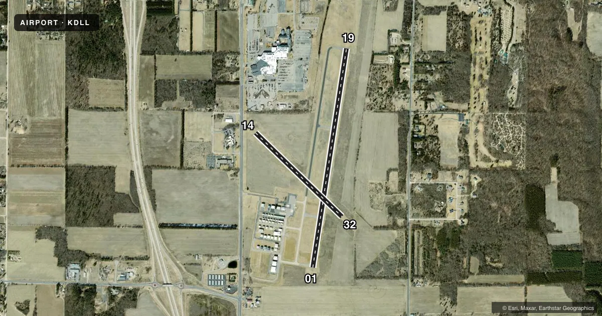
Airport sketch
Runways drawn to scale from FAA survey coordinates, rendered over satellite imagery. Not for navigation.
Approaches & charts
ILS · 1
Services on the field
Fuel grades, oxygen, maintenance, ramp storage and lighting — as declared to the FAA by the airport operator.
Fuel & services
- Fuel
- 100LLA+
- Oxygen (bottled)
- Not available
- Oxygen (bulk)
- Not available
- Airframe repair
- Major
- Power plant repair
- Major
- Other services
- INSTR,RNTL
Ramp & ground
- Transient storage
- Tie-down
- Hangar
- Landing fee
- No fee published
- Customs
- Not available
- Lighting schedule
- SEE RMK
- Beacon schedule
- SS-SR
- Beacon
- White / Green (civil land)(WG)
- Wind indicator
- Yes
- Segmented circle
- Yes
Fuel & FBOs
Cheapest 100LL and Jet A on the field and nearby. Always confirm with the FBO before taxi.
Airport notes
Surface conditions, obstructions, local procedures, lighting outages and other notes published with each FAA cycle.
General notes
- BIRDS ON & INVOF ARPT IN FALL.
- FOR CD CTC MADISON APP/DEP CON AT 608-249-8240. WHEN MADISON APCH CLSD, FOR CD CTC CHICAGO ARTCC AT 630-906-8921.
- RWY 14/32 NOT PLWD & CLSD NOV 15 THRU APR 15; CFM STS CTC - 608-356-2270.
- NOISE ABATEMENT: AVOID OVERFLIGHT OF WILDLIFE SANCTUARY 1.5 NM NE.
Lighting notes
- MIRL RWY 01/19 PRESET TO LOW SS-SR; TO INCR INTST & ACTVT REIL RWY 01 & 19; PAPI RWY 01 & 19 - CTAF.
Fuel notes
- 100LL24 HR FUEL AVBL WITH CREDIT CARD.
Approach & departure obstructions
- 14MKD WITH YELLOW/BLACK A-FRAMES AND YELLOW CONES.
- 32MKD WITH YELLOW/BLACK A-FRAMES AND YELLOW CONES.
- 01PAPI UNUSBL BYD 8 DEGS LEFT OF CNTRLN.
Other notes
- MANAGEREXTENSION 227
VFR map & nearby airports
VFR sectional. Tap any ICAO chip to open that airport.
Key facts · KDLL
Answer card- ICAO
- KDLL
- Name
- BARABOO/WISCONSIN DELLS RGNL
- Location
- BARABOO, WISCONSIN
- Elevation
- 980.2 ft MSL
- Traffic pattern altitude
- 1,980.2 ft MSL (1,000 AGL)
- Control tower
- Non-towered (use CTAF)
- Total runways
- 2
- Longest runway
- 01/19 · 5,010 ft
- Published ILS approaches
- 1
- Published frequencies
- 4
- Magnetic variation
- 1°
- Current flight rules
- VFR
- Current wind
- 200° at 7 kt
- Favored runway now
- RWY 19
Baraboo/Wisconsin Dells Rgnl sits in Baraboo, Wisconsin. Field elevation is 980.2 ft MSL. The airport has two runways. The longest is 01/19 at 5,010 ft asphalt. Runway 14/32 is 2,725 ft turf. There is no control tower, so plan to use CTAF 123.05 for self-announce traffic. One ILS is published for runway 01.
Pattern altitude is not published. Use the standard 1,000 ft AGL for light piston operations unless the current Chart Supplement says otherwise. Spring City Aviation is on the field. It carries 100LL and Jet A. 24-hour 100LL fuel is available with credit card.
A few local items matter here. Noise abatement calls for avoiding overflight of the wildlife sanctuary 1.5 NM northeast of the airport. Birds are reported in the area in fall. Runway 14/32 is not plowed and is closed from November 15 through April 15. Check its status with the airport before you plan to use it. Runway 01/19 has medium intensity lights that come up low from sunset to sunrise. Use the CTAF to increase intensity and to activate the runway end identifier lights on 01 and 19. For IFR work, clearance delivery goes through Madison Approach/Departure. If that is closed, use Chicago ARTCC.