METAR & TAF 6P3
6P3 does not publish a METAR.
Showing the nearest reporting station: KMSN (DANE COUNTY RGNL/TRUAX FLD) · 5.5 NM away. Conditions at 6P3 may differ.
METAR · KMSN
Observed 15:53Z
KMSN 271553Z 23007G15KT 10SM FEW018 FEW080 32/26 A2966 RMK AO2 LTG DSNT NE AND E SLP034 T03170256
- Wind
- 230° @ 7G15 kt
- Visibility
- 10 SM
- Temp / Dew
- 32°C / 26°C
- Altimeter
- 29.66 inHg
- Clouds
- FEW
- Density alt
- 3,546 ft
- Ceiling
- Unlimited
- Rules
- VFR
Airport info & contacts
Manager on record, flight service, ARTCC, attendance schedule and pattern altitude — published by the FAA and refreshed every 28 days.
Location
- From city
- 1 NM S
- VFR sectional
- CHICAGO
- ARTCC
- ZAU · CHICAGO
- NOTAM facility
- GRB (NOTAM-D)
Airport manager
- Name
- RYAN SOLVERSON & DAN SILVERS
- Phone
- 608-691-6161
- Address
- 112 WINSTON WAY, WAUNAKEE WI 53597
Flight service · Hours
- FSS GRB
- GREEN BAY1-800-WX-BRIEF
- Attendance
- Unattended
Frequencies
Tap any row to copy the frequency to your clipboard.
Runways & pattern
Full pagePattern entry · RWY 27
LEFT TRAFFICRunway end performance
| End | TORA | TODA | ASDA | LDA | VGSI | Approach lights | Obstruction |
|---|---|---|---|---|---|---|---|
| 27 | — | — | — | — | — | — | 50', trees, 553' from thr, 75' R of cntrln, slope 7 |
Declared distances in feet. TORA = takeoff run available, TODA = takeoff distance, ASDA = accelerate-stop, LDA = landing distance.
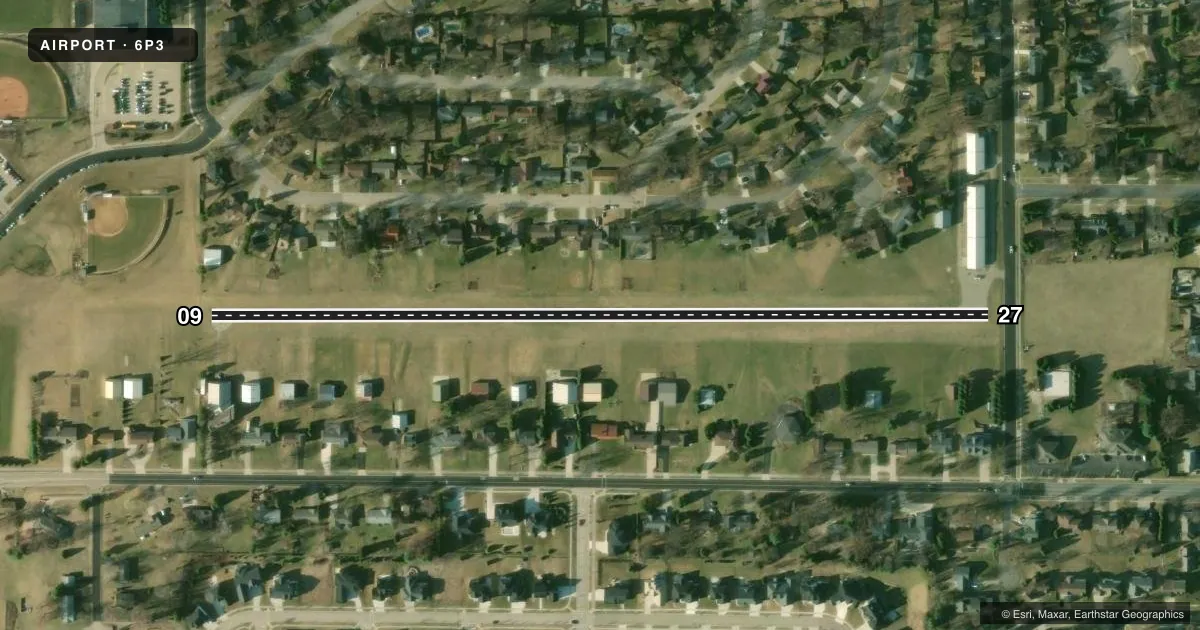
Airport sketch
Runways drawn to scale from FAA survey coordinates, rendered over satellite imagery. Not for navigation.
Approaches & charts
Services on the field
Fuel grades, oxygen, maintenance, ramp storage and lighting — as declared to the FAA by the airport operator.
Fuel & services
- Fuel
- 100LL
- Oxygen (bottled)
- Not available
- Oxygen (bulk)
- Not available
- Airframe repair
- Not available
- Power plant repair
- Not available
Ramp & ground
- Transient storage
- Tie-down
- Landing fee
- No fee published
- Customs
- Not available
- Lighting schedule
- SEE RMK
- Wind indicator
- Lighted
- Segmented circle
- No
Fuel & FBOs
Cheapest 100LL and Jet A on the field and nearby. Always confirm with the FBO before taxi.
Airport notes
Surface conditions, obstructions, local procedures, lighting outages and other notes published with each FAA cycle.
General notes
- FOR CD CTC MADISON APP/DEP CON AT 608-249-8240. WHEN MADISON APCH CLSD, FOR CD CTC CHICAGO ARTCC AT 630-906-8921.
Lighting notes
- ACTVT LIRL RWY 09/27 - CTAF.
Runway surface & condition
- 09/27NSTD LIRL 165 FT FM E END; 155 FT FM W END; 1910 FT OF RY IS LGTD. RY LGTS APROXLY 60 FT FM PAVEMENT EDGE.
Approach & departure obstructions
- 093 FT UTILITY BOX 40 FT FM RWY END, 70 R; 3 FT UTILITY BOX 30 FT FM RWY END, 70 L.
- 27ROAD 50 FT FM RWY END; 9 FT SIGN 90 FT FM RWY END, 100 FT L.
- 27NSTD DSPLCD THR MKGS.
- 27APCH RATIO 16:1 TO DSPLCD THR. 50 FT TREE 806 FT FM DSPCLD THR, 75 FT L.
Other notes
- E111 - NOT IN COMPLIANCE WITH FAR 157.
- MANAGEREMAIL ADDRESS: FLY@WAUNAKEEAIRPORT.COM
VFR map & nearby airports
VFR sectional. Tap any ICAO chip to open that airport.
Key facts · 6P3
Answer card- ICAO
- 6P3
- Name
- WAUNAKEE
- Location
- WAUNAKEE, WISCONSIN
- Elevation
- 954.4 ft MSL
- Traffic pattern altitude
- 1,954.4 ft MSL (1,000 AGL)
- Control tower
- Non-towered (use CTAF)
- Total runways
- 1
- Longest runway
- 09/27 · 2,223 ft
- Published ILS approaches
- 0
- Published frequencies
- 1
- Magnetic variation
- 0°
- Current flight rules
- VFR
- Current wind
- 230° at 7 kt
- Favored runway now
- RWY 27
Waunakee Airport sits in Waunakee, Wisconsin. Field elevation is 954.4 ft MSL. The airport has one asphalt runway, 09/27, which is 2,223 ft long. There is no control tower. CTAF is 122.9.
No ILS approaches are published here. Pattern altitude is not published, so use the standard 1,000 ft AGL for light piston traffic unless the current FAA Chart Supplement says otherwise. The field is small. Runway length matters. Plan your performance carefully, especially if you are landing with a tailwind or operating at higher weight.
Waunakee Airport has one on-field FBO. Waunakee Airport carries 100LL. Published remarks note nonstandard low-intensity runway lighting on 09/27. The lights are activated by CTAF. There are also published obstructions near both runway ends, including a road, signs, utility boxes and a tree off the 27 end. Runway 27 also has nonstandard displaced threshold markings. The airport is not in compliance with FAR 157.
For clearance delivery, contact Madison Approach/Departure Control at 608-249-8240. When Madison Approach is closed, contact Chicago ARTCC at 630-906-8921. If you are new to the field, brief the short runway, the lighting setup and the threshold markings before arrival.