METAR & TAF KMSN
Current METAR
Observed 15:53Z
KMSN 271553Z 23007G15KT 10SM FEW018 FEW080 32/26 A2966 RMK AO2 LTG DSNT NE AND E SLP034 T03170256
- Wind
- 230° @ 7G15 kt
- Visibility
- 10 SM
- Temp / Dew
- 32°C / 26°C
- Altimeter
- 29.66 inHg
- Clouds
- FEW
- Density alt
- 3,462 ft
- Ceiling
- Unlimited
- Rules
- VFR
Airport info & contacts
Manager on record, flight service, ARTCC, attendance schedule and pattern altitude — published by the FAA and refreshed every 28 days.
Location
- From city
- 5 NM NE
- VFR sectional
- CHICAGO
- ARTCC
- ZAU · CHICAGO
- NOTAM facility
- MSN (NOTAM-D)
Airport manager
- Name
- MARK PAPKO
- Phone
- 605-246-3390
- Address
- 4000 INTERNATIONAL LANE, MADISON WI 53704
Flight service · Hours
- FSS GRB
- GREEN BAY1-800-WX-BRIEF
- Attendance
- ALL
Frequencies
Tap any row to copy the frequency to your clipboard.
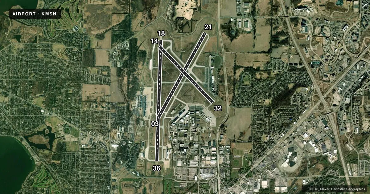
Runways & pattern
Full pagePattern entry · RWY 21
LEFT TRAFFIC| Runway | Heading (°M) | Length | Surface | Traffic |
|---|---|---|---|---|
| 18/36 | 179° / 359° | 9,006 ft | CONC | Standard L |
| 03/21Favored | 26° / 206° | 7,200 ft | CONC | Standard L |
| 14/32 | 133° / 313° | 5,846 ft | CONC | Standard L |
Runway end performance
| End | TORA | TODA | ASDA | LDA | VGSI | Approach lights | Obstruction |
|---|---|---|---|---|---|---|---|
| 18 | 9,006' | 9,006' | 9,006' | 8,606' | PAPI 4-box left(3°) | MALSR | 50', hill, 1634' from thr, 689' R of cntrln, slope 28 |
| 36 | 9,006' | 9,006' | 9,006' | 8,006' | PAPI 4-box left(3°) | ALSF2 | — |
| 03 | 7,200' | 7,200' | 7,200' | 6,770' | PAPI 4-box left(3°) | — | 72', trees, 2760' from thr, 460' R of cntrln, slope 35 |
| 21 | 6,770' | 6,770' | 7,015' | 7,015' | PAPI 4-box left(3°) | MALSR | 19', road, 2050' from thr, 0' R of cntrln, slope 50 |
| 14 | 5,846' | 5,846' | 5,846' | 5,369' | PAPI 4-box left(3°) | — | — |
| 32 | 5,846' | 5,846' | 5,846' | 5,846' | PAPI 4-box left(3°) | — | 112', tree, 4047' from thr, 440' R of cntrln, slope 34 |
Declared distances in feet. TORA = takeoff run available, TODA = takeoff distance, ASDA = accelerate-stop, LDA = landing distance.
Airport sketch
Runways drawn to scale from FAA survey coordinates, rendered over satellite imagery. Not for navigation.
Approaches & charts
ILS · 3
Services on the field
Fuel grades, oxygen, maintenance, ramp storage and lighting — as declared to the FAA by the airport operator.
Fuel & services
- Fuel
- 100LLAA++
- Oxygen (bottled)
- HIGH/LOW
- Airframe repair
- Major
- Power plant repair
- Major
- Other services
- AFRT,AMB,AVNCS,CARGO,CHTR,INSTR,RNTL,SALES
Ramp & ground
- Transient storage
- Hangar
- Landing fee
- No fee published
- Customs
- Not available
- Lighting schedule
- SEE RMK
- Beacon schedule
- SS-SR
- Beacon
- White / Green (civil land)(WG)
- Wind indicator
- Lighted
- Segmented circle
- No
Fuel & FBOs
Cheapest 100LL and Jet A on the field and nearby. Always confirm with the FBO before taxi.
Airport notes
Surface conditions, obstructions, local procedures, lighting outages and other notes published with each FAA cycle.
General notes
- W RAMP RSTRD TO ACR.
- NOISE ABATEMENT PROC IN EFCT; DEP RWY 03 & 36; ARR RWY 18 & 21.
- TBJT TRNG OPS PROH.
- BIRDS ON & INVOF ARPT.
- ANG: PPR - 115FW.PPR.ORG@US.AF.MIL. OPS HR 1200-2230Z++MON-THURS - D724-8642/8436/C608 245-4642/4436. H24 - D724-8580 H24/C608 245-4580.
- AVOID OTFC OF YAHARA RIVER INVOF ARPT BLW 2000 FT.
- RWY 14 & 18 APCH ENDS CLOSELY ALIGNED; VERIFY RWY & HDG BFR DEP.
- TWY L1, L6, B5, E & H NORTH OF RWY 14/32, E RAMP BTN TWY H & M CLSD TO WINGSPAN GTR THAN 118 FT. TWYS B1, J & B NORTH OF TWY M & E RAMP CLSD TO WINGSPAN GTR THAN 150 FT.
- ARNG: PPR; TSNT SVC LTD; HEL RQR SVC - ARMY OPS; 1300-2200Z++ MON, TUE; 1300-0400Z++ WED-FRI, CLSD SAT, SUN - D745-8310/C608-301-8310.
- HIGH RISK FLT TEST PPR - AMGR.
- ENG RUNUP N HOLD BAY ONLY.
- BARRICADES ALG W EDGE OF S RAMP ADJ MIL RAMP.
- W RAMP UNCTLD; PUSHBACK AT PILOT DISCRETION.
- AVGAS E OR S APRON ONLY.
- RWY 18, 21, 36 BAK-14 ARRESTING CABLE MIL USE ONLY; RETRACTED WHEN NOT IN USE.
- FOR CD CTC MADISON APP/DEP CON AT 608-249-8240. WHEN MADISON APCH CLSD, FOR CD CTC CHICAGO ARTCC AT 630-906-8921.
- TWY F MIL FIGHTER USE ONLY. TWY G PERM CLSD.
- GEN AVN SVC AVBL E RAMP ONLY.
Lighting notes
- ACTVT MALSR RWY 18 & 21; REIL RWY 03, 14 & 32; HIRL RWY 03/21, 14/32 & 18/36 - CTAF. WHEN ATCT CLSD HIRL RWY 18/36 PRESET LOW INTST; INCR INTST - CTAF.
Runway surface & condition
- 03/21PCR VALUE: 780/R/D/W/T
- 14/32PCR VALUE: 710/R/D/W/T
- 18/36PCR VALUE: 780/R/C/W/T
Approach & departure obstructions
- 36ALSF2 OPRS AS SSALR WHEN TWR CLSD.
- 18RWY CC NOT REPORTED.
- 36RWY CC NOT REPORTED.
- 18UNUSBL BYD 9 DEGS RIGHT OF CNTRLN.
- 03TAP
- 18APCH RATIO 40:1 FM DTHR.
Arresting gear
- 18_BAK-14BAK-14 BAK-12(B) (1900').
- 21_BAK-14BAK-14 BAK-12(B) (1620').
- 36_BAK-14BAK-14 BAK-12(B) (1750').
Other notes
- MILITARY: OVHD TFC PAT ALT RSTRD TO 3500 FT MSL; RWY 18/36 L TURN.
- MANAGERMATT POWERS - 608-661-6452
VFR map & nearby airports
VFR sectional. Tap any ICAO chip to open that airport.
Key facts · KMSN
Answer card- ICAO
- KMSN
- Name
- DANE COUNTY RGNL/TRUAX FLD
- Location
- MADISON, WISCONSIN
- Elevation
- 886.6 ft MSL
- Traffic pattern altitude
- 1,886.6 ft MSL (1,000 AGL)
- Control tower
- Towered · 0600-2300
- Total runways
- 3
- Longest runway
- 18/36 · 9,006 ft
- Published ILS approaches
- 3
- Published frequencies
- 20
- Magnetic variation
- 3°
- Current flight rules
- VFR
- Current wind
- 230° at 7 kt
- Favored runway now
- RWY 21
Dane County Rgnl/Truax Fld sits in Madison, Wisconsin. Field elevation is 886.6 ft MSL. The airport has 3 runways. The longest is 18/36 at 9,006 ft. The tower is open 0600 to 2300. When the tower is closed, runway 18/36 HIRL is preset to low intensity. Increase intensity on CTAF. The field has 3 ILS approaches for runway ends 18, 21 and 36.
Pattern altitude is not published. Use 1,000 ft AGL for light piston traffic unless the current Chart Supplement says otherwise. Wisconsin Aviation is on the field. It carries 100LL, Jet A and Jet A Pr. Call ahead at (608) 268-5006 for current service details.
This is a busy Class C airport with noise abatement in effect. Departures are published for runways 03 and 36. Arrivals are published for runways 18 and 21. Touch-and-go training is prohibited. Engine runup is permitted in the hold bay only. The published remarks also note arresting gear on runway 21 at 1,620 ft. They also note arresting gear on runway 36 at 1,750 ft. If you are planning a military or special-use operation, check the current Chart Supplement and coordinate with the airport operator before you go.