METAR & TAF 54W
54W does not publish a METAR.
Showing the nearest reporting station: KEFT (MONROE MUNI) · 9.6 NM away. Conditions at 54W may differ.
METAR · KEFT
Observed 15:35Z
KEFT 271535Z AUTO 23016G22KT 10SM SCT013 31/26 A2973 RMK AO2 T03050264
- Wind
- 230° @ 16G22 kt
- Visibility
- 10 SM
- Temp / Dew
- 31°C / 26°C
- Altimeter
- 29.73 inHg
- Clouds
- SCT
- Density alt
- 3,172 ft
- Ceiling
- Unlimited
- Rules
- VFR
Airport info & contacts
Manager on record, flight service, ARTCC, attendance schedule and pattern altitude — published by the FAA and refreshed every 28 days.
Location
- From city
- 1 NM NE
- VFR sectional
- CHICAGO
- ARTCC
- ZAU · CHICAGO
- NOTAM facility
- GRB (NOTAM-D)
Airport manager
- Name
- PAUL WAGNER
- Phone
- 608-438-0017
- Address
- W9478 WHITE OAK RD, ARGYLE WI 53504
Flight service · Hours
- FSS GRB
- GREEN BAY1-800-WX-BRIEF
- Attendance
- Unattended
Frequencies
Tap any row to copy the frequency to your clipboard.
Runways & pattern
Full pagePattern entry · RWY 27
LEFT TRAFFICRunway end performance
| End | TORA | TODA | ASDA | LDA | VGSI | Approach lights | Obstruction |
|---|---|---|---|---|---|---|---|
| 09 | — | — | — | — | — | — | 45', trees, 10' from thr, 125' R of cntrln, slope 0 |
Declared distances in feet. TORA = takeoff run available, TODA = takeoff distance, ASDA = accelerate-stop, LDA = landing distance.
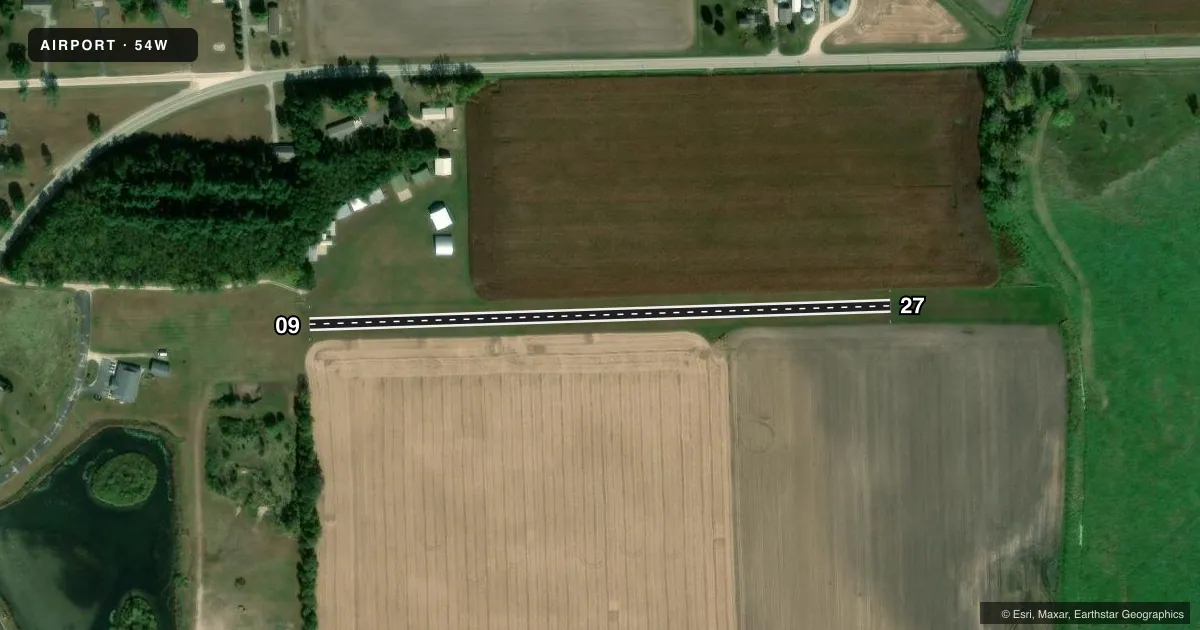
Airport sketch
Runways drawn to scale from FAA survey coordinates, rendered over satellite imagery. Not for navigation.
Approaches & charts
Services on the field
Fuel grades, oxygen, maintenance, ramp storage and lighting — as declared to the FAA by the airport operator.
Fuel & services
- Fuel
- Not available
- Oxygen (bulk)
- Not available
- Airframe repair
- Not available
- Power plant repair
- Not available
Ramp & ground
- Transient storage
- Not published
- Landing fee
- No fee published
- Wind indicator
- Yes
- Segmented circle
- No
Fuel & FBOs
Cheapest 100LL and Jet A on the field and nearby. Always confirm with the FBO before taxi.
Airport notes
Surface conditions, obstructions, local procedures, lighting outages and other notes published with each FAA cycle.
General notes
- WINTER RWY MAINT NA. CTC AMGR FOR CONDS.
- FOR CD CTC CHICAGO ARTCC AT 630-906-8921.
- DEER & BIRDS ON & INVOF ARPT.
Approach & departure obstructions
- 09MKD WITH RED/WHITE A-FRAMES.
- 27MKD WITH RED/WHITE A-FRAMES.
Other notes
- PRVDD VFR OPNS ONLY.
VFR map & nearby airports
VFR sectional. Tap any ICAO chip to open that airport.
Key facts · 54W
Answer card- ICAO
- 54W
- Name
- ALBANY
- Location
- ALBANY, WISCONSIN
- Elevation
- 820 ft MSL
- Traffic pattern altitude
- 1,820 ft MSL (1,000 AGL)
- Control tower
- Non-towered (use CTAF)
- Total runways
- 1
- Longest runway
- 09/27 · 1,675 ft
- Published ILS approaches
- 0
- Published frequencies
- 1
- Magnetic variation
- 0°
- Current flight rules
- VFR
- Current wind
- 230° at 16 kt
- Favored runway now
- RWY 27
Albany Airport (54W) sits in Albany, Wisconsin. Field elevation is 820 ft MSL. It has one runway. Runway 09/27 is turf and measures 1,675 ft, which is also the longest runway on the field. This is a VFR-only airport. No control tower is published. CTAF is 122.9.
No ILS approaches are published here. Pattern altitude is not published, so use the standard 1,000 ft AGL for light piston operations unless the current Chart Supplement says otherwise. The field is small and the runway is short. Plan your performance with that in mind, especially if the surface is soft or wet. Published remarks also note deer and birds in the area. That matters on takeoff and landing, especially at low altitude and in the pattern.
There are no on-field FBOs listed. If you need fuel or local services, contact the airport operator or call ahead before you go. For clearance delivery, Chicago ARTCC is listed at 630-906-8921. Winter runway conditions are handled through the airport manager at 608-438-0017. If you are checking in from a larger airport, expect a quiet turf strip with basic VFR operations and no published instrument approach support.