METAR & TAF C37
C37 does not publish a METAR.
Showing the nearest reporting station: KEFT (MONROE MUNI) · 9.3 NM away. Conditions at C37 may differ.
METAR · KEFT
Observed 15:55Z
KEFT 271555Z AUTO 23018G22KT 10SM SCT015 32/26 A2972 RMK AO2 LTG DSNT NE AND E T03150259
- Wind
- 230° @ 18G22 kt
- Visibility
- 10 SM
- Temp / Dew
- 32°C / 26°C
- Altimeter
- 29.72 inHg
- Clouds
- SCT
- Density alt
- 3,270 ft
- Ceiling
- Unlimited
- Rules
- VFR
Airport info & contacts
Manager on record, flight service, ARTCC, attendance schedule and pattern altitude — published by the FAA and refreshed every 28 days.
Location
- From city
- 2 NM S
- VFR sectional
- CHICAGO
- Pattern altitude
- 800 ft AGL · 1,592 ft MSL
- ARTCC
- ZAU · CHICAGO
- NOTAM facility
- GRB (NOTAM-D)
Airport manager
- Name
- DREW HALLAM
- Phone
- 608-879-5425
- Address
- P O BOX 286, BRODHEAD WI 53520
Flight service · Hours
- FSS GRB
- GREEN BAY1-800-WX-BRIEF
- Attendance
- Unattended
Frequencies
Tap any row to copy the frequency to your clipboard.
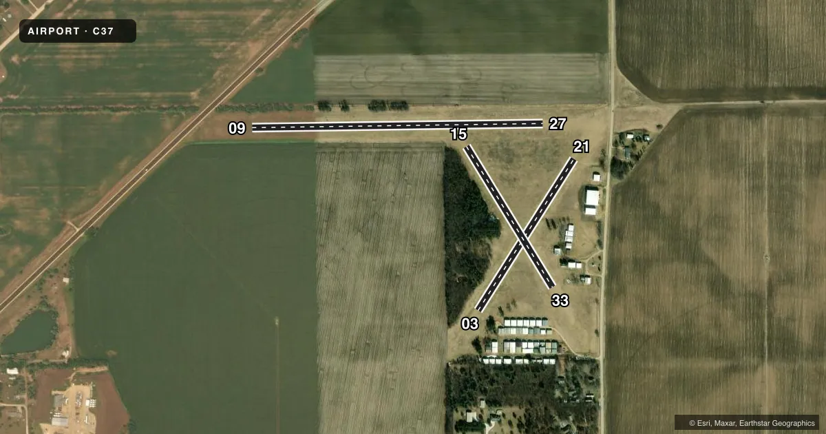
Runways & pattern
Full pagePattern entry · RWY 21
LEFT TRAFFIC| Runway | Heading (°M) | Length | Surface | Traffic |
|---|---|---|---|---|
| 09/27 | 89° / 269° | 2,440 ft | TURF | Standard L |
| 03/21Favored | 32° / 212° | 1,500 ft | TURF | Standard L |
| 15/33 | 148° / 328° | 1,380 ft | TURF | Standard L |
Runway end performance
| End | TORA | TODA | ASDA | LDA | VGSI | Approach lights | Obstruction |
|---|---|---|---|---|---|---|---|
| 09 | — | — | — | — | — | — | 65', trees, 680' from thr, 160' R of cntrln, slope 10 |
| 27 | — | — | — | — | — | — | 50', trees, 670' from thr, 120' R of cntrln, slope 13 |
| 03 | — | — | — | — | — | — | 58', trees, 700' from thr, 160' R of cntrln, slope 12 |
| 33 | — | — | — | — | — | — | 43', trees, 615' from thr, 170' R of cntrln, slope 14 |
Declared distances in feet. TORA = takeoff run available, TODA = takeoff distance, ASDA = accelerate-stop, LDA = landing distance.
Airport sketch
Runways drawn to scale from FAA survey coordinates, rendered over satellite imagery. Not for navigation.
Approaches & charts
Services on the field
Fuel grades, oxygen, maintenance, ramp storage and lighting — as declared to the FAA by the airport operator.
Fuel & services
- Fuel
- Not available
- Oxygen (bottled)
- Not available
- Oxygen (bulk)
- Not available
- Airframe repair
- Minor
- Power plant repair
- Minor
Ramp & ground
- Transient storage
- Tie-down
- Landing fee
- No fee published
- Lighting schedule
- SEE RMK
- Wind indicator
- Lighted
- Segmented circle
- No
Fuel & FBOs
Cheapest 100LL and Jet A on the field and nearby. Always confirm with the FBO before taxi.
Airport notes
Surface conditions, obstructions, local procedures, lighting outages and other notes published with each FAA cycle.
General notes
- RYS NOT PLOWED IN WINTER; OPEN TO SKI ACFT.
- CROP DUSTING OPNS IN AREA.
- DEER INVOF MOVEMENT AREAS.
- IRRIGATION EQUIP NR MOVEMENT AREAS.
- FOR CD CTC CHICAGO ARTCC AT 630-906-8921.
Lighting notes
- ACTVT LIRL RY 09/27 - CTAF.
Runway surface & condition
- 09/27RY 9/27 NSTD LIRL. SPACING.
Approach & departure obstructions
- 03RWY 03/21 MKD WITH RED & WHITE HALF BARRELS.
- 09RWY 09/27 MKD WITH RED & WHITE HALF BARRELS.
- 33RY 33 MARKED WITH CONCRETE PAD.
Other notes
- MANAGEREMAIL ADDRESS: AIRPORTMANAGER@HAWK-AIRE.COM
VFR map & nearby airports
VFR sectional. Tap any ICAO chip to open that airport.
Key facts · C37
Answer card- ICAO
- C37
- Name
- BRODHEAD
- Location
- BRODHEAD, WISCONSIN
- Elevation
- 792 ft MSL
- Traffic pattern altitude
- 1,592 ft MSL (800 AGL)
- Control tower
- Non-towered (use CTAF)
- Total runways
- 3
- Longest runway
- 09/27 · 2,440 ft
- Published ILS approaches
- 0
- Published frequencies
- 1
- Magnetic variation
- 0°
- Current flight rules
- VFR
- Current wind
- 230° at 18 kt
- Favored runway now
- RWY 21
Brodhead Airport sits in Brodhead, Wisconsin. Field elevation is 792 ft MSL. It is an uncontrolled field with no tower. The pattern altitude is 800 ft AGL, which is 1,592 ft MSL. The airport has three turf runways. The longest is runway 09/27 at 2,440 ft. No ILS approaches are published here.
Runway 09/27 has low intensity lighting that is activated by CTAF. The published remarks also note red and white half barrels on runways 09/27 and 03/21. Runway 33 has a concrete pad marking. Expect crop dusting activity in the area. Deer are also reported near movement areas. Irrigation equipment is near the runways too. In winter the runways are not plowed. Ski aircraft are allowed when conditions support it.
There are no on-field FBOs listed in the facts. Contact the airport operator directly before arrival if you need local services. CTAF is 122.9. For clearance delivery, the Chart Supplement says to contact Chicago ARTCC at 630-906-8921. First-time visitors should pay close attention to the turf surface. They should also note the marked runway ends and the low intensity lighting setup on 09/27.