METAR & TAF KJVL
Current METAR
Observed 01:45Z
KJVL 270145Z 00000KT 10SM SCT040 28/28 A2985
- Wind
- 000° @ 0 kt
- Visibility
- 10 SM
- Temp / Dew
- 28°C / 28°C
- Altimeter
- 29.85 inHg
- Clouds
- SCT
- Density alt
- 2,648 ft
- Ceiling
- Unlimited
- Rules
- VFR
Airport info & contacts
Manager on record, flight service, ARTCC, attendance schedule and pattern altitude — published by the FAA and refreshed every 28 days.
Location
- From city
- 3 NM SW
- VFR sectional
- CHICAGO
- ARTCC
- ZAU · CHICAGO
- NOTAM facility
- JVL (NOTAM-D)
Airport manager
- Name
- AIMEE SCRIMA
- Phone
- 608-757-5768
- Address
- 1716 W. AIRPORT RD, JANESVILLE WI 53546
Flight service · Hours
- FSS GRB
- GREEN BAY1-800-WX-BRIEF
- Attendance
- 0700-1530
Frequencies
Tap any row to copy the frequency to your clipboard.
Runways & pattern
Full pagePattern entry · RWY 14
LEFT TRAFFIC| Runway | Heading (°M) | Length | Surface | Traffic |
|---|---|---|---|---|
| 14/32 | 132° / 312° | 7,302 ft | CONC | Standard L |
| 04/22 | 40° / 220° | 6,701 ft | ASPH | Standard L |
| 18/36 | 177° / 357° | 5,004 ft | ASPH | Standard L |
Runway end performance
| End | TORA | TODA | ASDA | LDA | VGSI | Approach lights | Obstruction |
|---|---|---|---|---|---|---|---|
| 14 | 7,302' | 7,302' | 7,302' | 7,302' | PAPI 4-box left(3°) | — | — |
| 32 | 7,302' | 7,302' | 7,302' | 7,302' | VASI 4-box left(3°) | MALSR | — |
| 04 | 6,701' | 6,701' | 6,701' | 6,701' | PAPI 4-box left(3°) | MALSR | — |
| 22 | 6,701' | 6,701' | 6,701' | 6,701' | PAPI 4-box left(3°) | — | 83', tree, 2792' from thr, 367' R of cntrln, slope 31 |
| 18 | 5,004' | 5,004' | 5,004' | 5,004' | — | — | 16', road, 385' from thr, 20' R of cntrln, slope 11 |
| 36 | 5,004' | 5,004' | 5,004' | 5,004' | — | — | — |
Declared distances in feet. TORA = takeoff run available, TODA = takeoff distance, ASDA = accelerate-stop, LDA = landing distance.
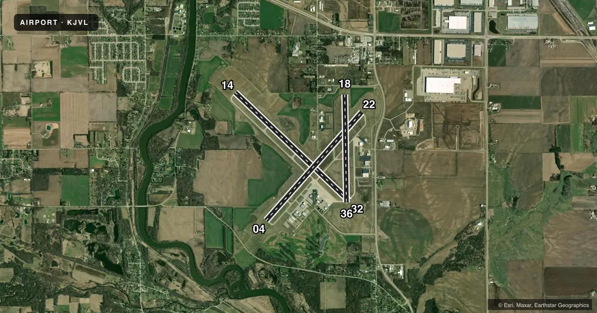
Airport sketch
Runways drawn to scale from FAA survey coordinates, rendered over satellite imagery. Not for navigation.
Approaches & charts
ILS · 2
Services on the field
Fuel grades, oxygen, maintenance, ramp storage and lighting — as declared to the FAA by the airport operator.
Fuel & services
- Fuel
- 100LLA
- Airframe repair
- Major
- Power plant repair
- Major
- Other services
- AMB,AVNCS,CHTR,INSTR,RNTL
Ramp & ground
- Transient storage
- Tie-down
- Hangar
- Landing fee
- No fee published
- Customs
- Not available
- Lighting schedule
- SEE RMK
- Beacon schedule
- SS-SR
- Beacon
- White / Green (civil land)(WG)
- Wind indicator
- Lighted
- Segmented circle
- Yes
Fuel & FBOs
Cheapest 100LL and Jet A on the field and nearby. Always confirm with the FBO before taxi.
Airport notes
Surface conditions, obstructions, local procedures, lighting outages and other notes published with each FAA cycle.
General notes
- LGT SPORT ACFT WITH CRUISE SPEED OF 60 MPH OR LESS ENTER TFC PAT AT 500 AGL.
- RWY 32 & 36 ENDS CLOSELY ALIGNED; VERIFY RWY & HDG BFR DEP.
Lighting notes
- ACTVT MALSR RWY 04 & 32; REIL RWY 14 & 22; VASI RWY 32; HIRL RWY 04/22 & 14/32; MIRL RWY 18/36 - CTAF. WHEN ATCT CLSD HIRL RWY 04/22 PRESET TO LOW INTST; INCR INTST - CTAF. PAPI RWY 04, 14, & 22 OPR CONSLY.
Runway surface & condition
- 04/22APRONS & RAMPS RSTD TO 155 DTW GROSS WT.
- 04/22PCR VALUE: 170/R/D/X/T
- 14/32PCR VALUE: 440/R/B/X/T
- 18/36PCR VALUE: 130/F/C/X/T
- 04/22RWY 04/22 NOT AVBL FOR PART 121/PART 380 OPS WITH SKED PAX CARRYING OPS MORE THAN 9 PAX SEATS AND NON-SKED PAX CARRYING OPS MORE THAN 30 PAX SEATS. 90 DAY PPR FOR UNSKED ACR OPS GTR THAN 30 PAX SEATS - AMGR.
- 14/32RWY 14/32 NOT AVBL FOR PART 121/PART 380 OPS WITH SKED PAX CARRYING OPS MORE THAN 9 PAX SEATS AND NON-SKED PAX CARRYING OPS MORE THAN 30 PAX SEATS. 90 DAY PPR FOR UNSKED ACR OPS GTR THAN 30 PAX SEATS - AMGR.
- 18/36RWY 18/36 NOT AVBL FOR PART 121/PART 380 OPS WITH SKED PAX CARRYING OPS MORE THAN 9 PAX SEATS AND NON-SKED PAX CARRYING OPS MORE THAN 30 PAX SEATS. 90 DAY PPR FOR UNSKED ACR OPS GTR THAN 30 PAX SEATS - AMGR.
Other notes
- 1CONDS UNMNT MON-FRI 1530-0700, WKEND & FED HOL.
VFR map & nearby airports
VFR sectional. Tap any ICAO chip to open that airport.
Key facts · KJVL
Answer card- ICAO
- KJVL
- Name
- SOUTHERN WISCONSIN RGNL
- Location
- JANESVILLE, WISCONSIN
- Elevation
- 807.8 ft MSL
- Traffic pattern altitude
- 1,807.8 ft MSL (1,000 AGL)
- Control tower
- Towered · 0600-2100
- Total runways
- 3
- Longest runway
- 14/32 · 7,302 ft
- Published ILS approaches
- 2
- Published frequencies
- 12
- Magnetic variation
- 2°
- Current flight rules
- VFR
- Current wind
- 000° at 0 kt
- Favored runway now
- –
Southern Wisconsin Rgnl is in Janesville, Wisconsin. Field elevation is 807.8 ft MSL. The airport has 3 runways. The longest is runway 14/32 at 7,302 ft. The tower is open daily from 0600 to 2100. Two ILS approaches are published. They are on runway ends 04 and 32.
The pattern altitude is not published in the facts. Use 1,000 ft AGL for light piston traffic unless ATC or the current Chart Supplement says otherwise. Revv Aviation is on the field. It carries 100LL, Jet A and Jet A Prist. The airport remarks also note that runway 32 and runway 36 ends are closely aligned. Verify the runway and heading before departure.
This is a busy controlled field with three paved runways and multiple lighting systems. Runway 04/22 and 14/32 have high intensity lighting. Runway 18/36 uses medium intensity lighting controlled by CTAF. When the tower is closed, runway 04/22 high intensity lighting is preset to low intensity. Increase it on CTAF if needed. Runway 04 and 32 also have MALSR. Runway 14, 22 and 32 have published visual glide path aids. Check the current Chart Supplement for any noise or curfew restrictions before flying in. The airport also notes that conditions are unmonitored from Monday through Friday 1530 to 0700. Conditions are also unmonitored on weekends and federal holidays.