METAR & TAF C59
C59 does not publish a METAR.
Showing the nearest reporting station: KBUU (BURLINGTON MUNI) · 13.5 NM away. Conditions at C59 may differ.
METAR · KBUU
Observed 13:15Z
KBUU 271315Z AUTO 17004KT 4SM OVC003 27/26 A2982 RMK AO2 T02660260 PWINO
- Wind
- 170° @ 4 kt
- Visibility
- 4 SM
- Temp / Dew
- 27°C / 26°C
- Altimeter
- 29.82 inHg
- Clouds
- OVC
- Density alt
- 2,780 ft
- Ceiling
- 300 ft AGL
- Rules
- LIFR
Airport info & contacts
Manager on record, flight service, ARTCC, attendance schedule and pattern altitude — published by the FAA and refreshed every 28 days.
Location
- From city
- 2 NM E
- VFR sectional
- CHICAGO
- ARTCC
- ZAU · CHICAGO
- NOTAM facility
- GRB (NOTAM-D)
Airport manager
- Name
- DANIEL LYNG
- Phone
- (262) 725-9127
- Address
- 2400 EAST GENEVA ST, DELAVAN WI 53115
Flight service · Hours
- FSS GRB
- GREEN BAY1-800-WX-BRIEF
- Attendance
- Unattended
Frequencies
Tap any row to copy the frequency to your clipboard.
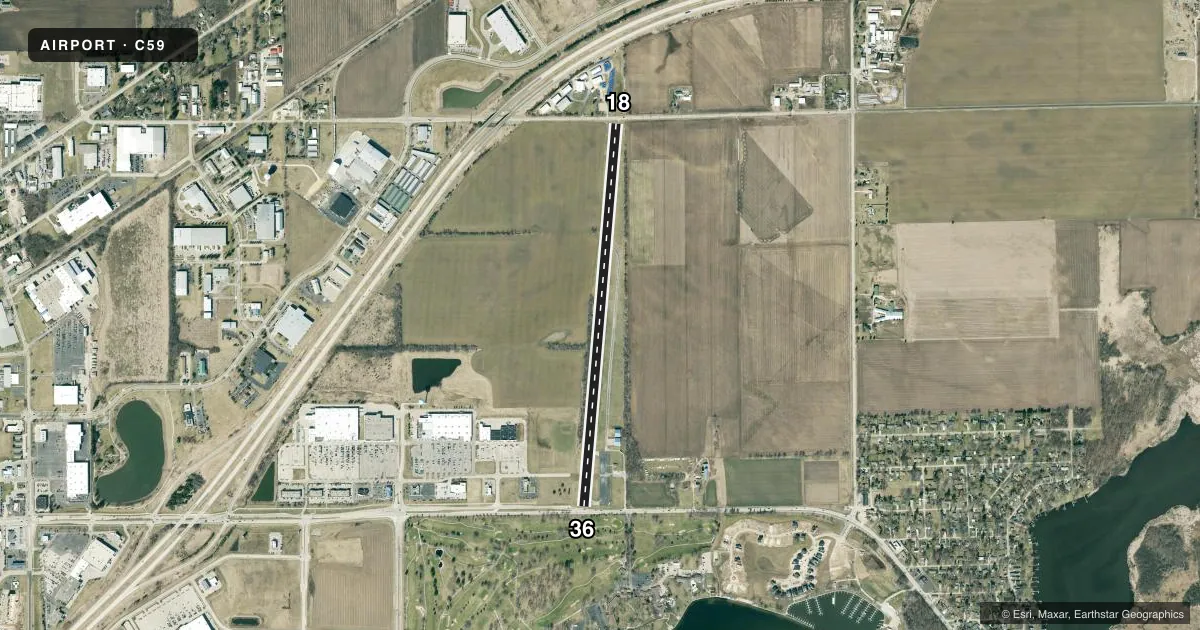
Runways & pattern
Full pagePattern entry · RWY 18
LEFT TRAFFICRunway end performance
| End | TORA | TODA | ASDA | LDA | VGSI | Approach lights | Obstruction |
|---|---|---|---|---|---|---|---|
| 18 | — | — | — | — | — | — | 19', tree, 242' from thr, 120' R of cntrln, slope 2 |
| 36 | — | — | — | — | — | — | 10', tree, 290' from thr, 45' R of cntrln, slope 9 |
Declared distances in feet. TORA = takeoff run available, TODA = takeoff distance, ASDA = accelerate-stop, LDA = landing distance.
Airport sketch
Runways drawn to scale from FAA survey coordinates, rendered over satellite imagery. Not for navigation.
Approaches & charts
Services on the field
Fuel grades, oxygen, maintenance, ramp storage and lighting — as declared to the FAA by the airport operator.
Fuel & services
- Fuel
- Not available
- Oxygen (bottled)
- Not available
- Oxygen (bulk)
- Not available
- Airframe repair
- Not available
- Power plant repair
- Not available
Ramp & ground
- Transient storage
- Tie-down
- Landing fee
- No fee published
- Customs
- Not available
- Wind indicator
- Yes
- Segmented circle
- No
Fuel & FBOs
Cheapest 100LL and Jet A on the field and nearby. Always confirm with the FBO before taxi.
Airport notes
Surface conditions, obstructions, local procedures, lighting outages and other notes published with each FAA cycle.
General notes
- ARPT CLSD FOR NIGHT OPNS.
- LOW WING ACFT AVOID SOUTH TWY, 25 FT FM TWY CENTERLINE TO 3 FT FENCE.
- FOR CD CTC CHICAGO ARTCC AT 630-906-8921.
Approach & departure obstructions
- 184 FT FENCE 12 FT FM RWY END; RD 40 FT FM RWY END.
- 364 FT FENCE 5 FT FM RWY END; RD 30 FT FM RWY END.
- 18MARKINGS FADED.
- 36MARKINGS FADED.
- 18APCH RATIO 20:1 TO DSPLCD THR.
- 36APCH RATIO 20:1 TO DSPLCD THR.
Other notes
- TFC PTN OPER TO W OF DELAVAN LAKE BTWN ARPT & TWIST ARPT 1 1/2 NM SE.
VFR map & nearby airports
VFR sectional. Tap any ICAO chip to open that airport.
Key facts · C59
Answer card- ICAO
- C59
- Name
- LAKE LAWN
- Location
- DELAVAN, WISCONSIN
- Elevation
- 981 ft MSL
- Traffic pattern altitude
- 1,981 ft MSL (1,000 AGL)
- Control tower
- Non-towered (use CTAF)
- Total runways
- 1
- Longest runway
- 18/36 · 4,423 ft
- Published ILS approaches
- 0
- Published frequencies
- 3
- Magnetic variation
- 2°
- Current flight rules
- LIFR
- Current wind
- 170° at 4 kt
- Favored runway now
- RWY 18
Lake Lawn (C59) is in Delavan, Wisconsin. The field elevation is 981 ft MSL. It has one runway. Runway 18/36 is 4,423 ft long and asphalt. There is no control tower. No ILS approaches are published. The pattern altitude is not published, so use the standard 1,000 ft AGL for light piston traffic unless the current Chart Supplement says otherwise.
This is a non-towered field with traffic operating west of Delavan Lake between the airport and Twist Airport 1.5 NM southeast. The airport is closed for night operations. Runway 18 and runway 36 both have faded markings. Runway 18 has a 4-foot fence 12 feet from the runway end plus a road 40 feet from the end. Runway 36 has a 4-foot fence 5 feet from the runway end plus a road 30 feet from the end. The published approach ratio is 20 to 1 to the displaced threshold on both ends. Low wing aircraft should avoid the south taxiway because a 3-foot fence sits close to the taxiway centerline. For clearance delivery, contact Chicago ARTCC at 630-906-8921. There are no on-field FBOs listed, so verify services with the airport operator or call ahead before arrival.