METAR & TAF 7V3
7V3 does not publish a METAR.
Showing the nearest reporting station: KJVL (SOUTHERN WISCONSIN RGNL) · 18.1 NM away. Conditions at 7V3 may differ.
METAR · KJVL
Observed 01:45Z
KJVL 270145Z 00000KT 10SM SCT040 28/28 A2985
- Wind
- 000° @ 0 kt
- Visibility
- 10 SM
- Temp / Dew
- 28°C / 28°C
- Altimeter
- 29.85 inHg
- Clouds
- SCT
- Density alt
- 2,822 ft
- Ceiling
- Unlimited
- Rules
- VFR
Airport info & contacts
Manager on record, flight service, ARTCC, attendance schedule and pattern altitude — published by the FAA and refreshed every 28 days.
Location
- From city
- 3 NM W
- VFR sectional
- CHICAGO
- Pattern altitude
- 800 ft AGL · 1,748 ft MSL
- ARTCC
- ZAU · CHICAGO
- NOTAM facility
- GRB (NOTAM-D)
Airport manager
- Name
- JIM BAIR
- Phone
- (262) 745-3299
- Address
- 1020 TARRANT DRIVE, FONTANA WI 53125
Flight service · Hours
- FSS GRB
- GREEN BAY1-800-WX-BRIEF
- Attendance
- Unattended
Frequencies
Tap any row to copy the frequency to your clipboard.
Runways & pattern
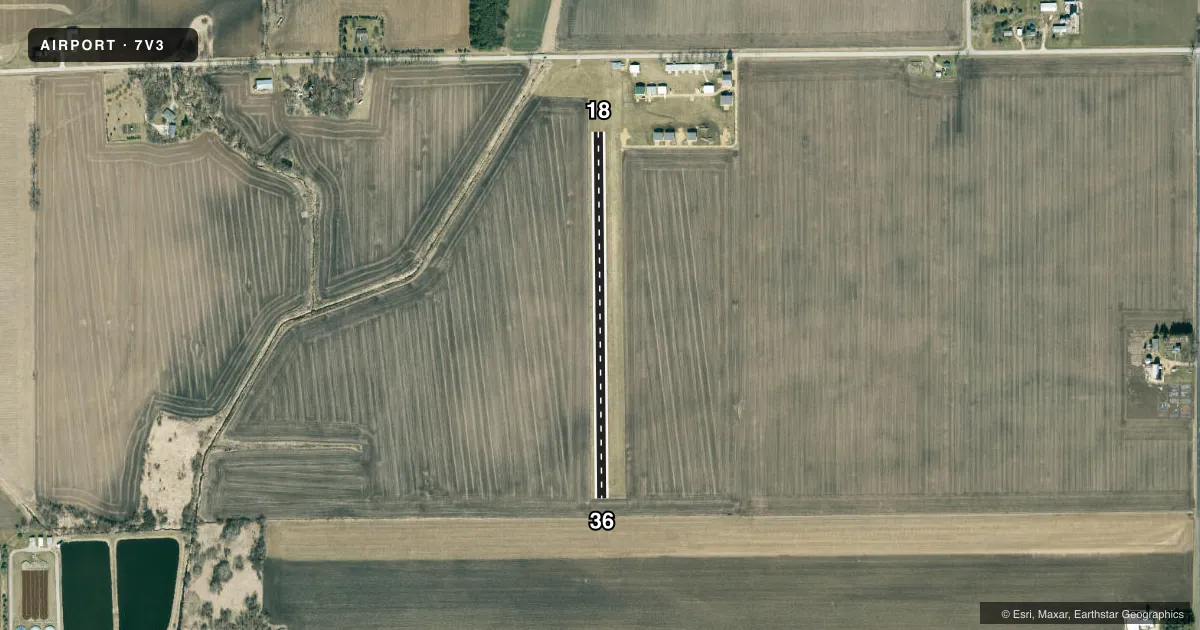
Full pagePattern entry · RWY 18
LEFT TRAFFICAirport sketch
Runways drawn to scale from FAA survey coordinates, rendered over satellite imagery. Not for navigation.
Approaches & charts
Services on the field
Fuel grades, oxygen, maintenance, ramp storage and lighting — as declared to the FAA by the airport operator.
Fuel & services
- Fuel
- Not available
- Oxygen (bottled)
- Not available
- Oxygen (bulk)
- Not available
Ramp & ground
- Transient storage
- Tie-down
- Landing fee
- No fee published
- Customs
- Not available
- Lighting schedule
- SEE RMK
- Wind indicator
- Yes
- Segmented circle
- No
Fuel & FBOs
Cheapest 100LL and Jet A on the field and nearby. Always confirm with the FBO before taxi.
Airport notes
Surface conditions, obstructions, local procedures, lighting outages and other notes published with each FAA cycle.
General notes
- RWY NOT PLWD WINT MONTHS - OPEN TO SKI EQUIPPED ACFT ONLY.
- FOR CD CTC CHICAGO ARTCC AT 630-906-8921.
Lighting notes
- ACTVT LIRL ON RY 18/36 - 123.75.
Runway surface & condition
- 18/36NSTD LIRL; RY 18 THLD LGTS ARE 45 FT S OF RY MARKERS.
Approach & departure obstructions
- 18RWY 18/36 MKD WITH YELLOW HALF BARRELS.
Other notes
- ESTAB PRIOR TO 1959.
- MANAGEREMAIL ADDRESS: JAMES.C.BAIR@GMAIL.COM (ALL LOWER CASE)
VFR map & nearby airports
VFR sectional. Tap any ICAO chip to open that airport.
Key facts · 7V3
Answer card- ICAO
- 7V3
- Name
- BIG FOOT AIRFIELD
- Location
- WALWORTH, WISCONSIN
- Elevation
- 948 ft MSL
- Traffic pattern altitude
- 1,748 ft MSL (800 AGL)
- Control tower
- Non-towered (use CTAF)
- Total runways
- 1
- Longest runway
- 18/36 · 2,114 ft
- Published ILS approaches
- 0
- Published frequencies
- 1
- Magnetic variation
- 0°
- Current flight rules
- VFR
- Current wind
- 000° at 0 kt
- Favored runway now
- –
Big Foot Airfield sits in Walworth, Wisconsin. The field elevation is 948 ft MSL. It has one runway. Runway 18/36 is 2,114 ft of turf, so plan for a short-field surface with no paved option on site. There is no control tower. CTAF is 122.9.
The published pattern altitude is 800 ft AGL, which is 1,748 ft MSL. No ILS approaches are published here, so if you are planning an instrument arrival, check the current FAA Chart Supplement for the latest approach options and any notes that affect your flight. The runway is not plowed in winter. Published remarks say the airport is open to ski-equipped aircraft only during those months. That is the main operational limiter for first-time visitors.
Low intensity runway lights are installed on 18/36. They can be controlled on 123.75. The runway is marked with yellow half barrels. The 18 threshold lights are set 45 feet south of the runway markers. There are no on-field FBOs listed, so contact the airport operator directly or the FBO directly by phone before arrival if you need services. Clearance delivery is handled through Chicago ARTCC at 630-906-8921 when needed.