METAR & TAF 57C
Current METAR
Observed 12:15Z
K57C 261215Z AUTO 00000KT 10SM CLR 14/14 A3010 RMK AO2 T01400139
- Wind
- 000° @ 0 kt
- Visibility
- 10 SM
- Temp / Dew
- 14°C / 14°C
- Altimeter
- 30.10 inHg
- Clouds
- CLR
- Density alt
- 724 ft
- Ceiling
- Unlimited
- Rules
- VFR
Airport info & contacts
Manager on record, flight service, ARTCC, attendance schedule and pattern altitude — published by the FAA and refreshed every 28 days.
Location
- From city
- 2 NM NE
- VFR sectional
- CHICAGO
- ARTCC
- ZAU · CHICAGO
- NOTAM facility
- GRB (NOTAM-D)
Airport manager
- Name
- DOUG GAUGER
- Phone
- 262-642-5008
- Address
- 2015 ENERGY DR, EAST TROY WI 53120
Flight service · Hours
- FSS GRB
- GREEN BAY1-800-WX-BRIEF
- Attendance
- MON-FRI · IREG
Frequencies
Tap any row to copy the frequency to your clipboard.
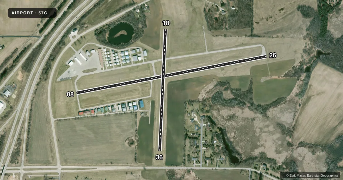
Runways & pattern
Full pagePattern entry · RWY 08
LEFT TRAFFIC| Runway | Heading (°M) | Length | Surface | Traffic |
|---|---|---|---|---|
| 08/26 | 77° / 257° | 3,900 ft | ASPH | Standard L |
| 18/36 | 181° / 1° | 2,446 ft | TURF | Standard L |
Runway end performance
| End | TORA | TODA | ASDA | LDA | VGSI | Approach lights | Obstruction |
|---|---|---|---|---|---|---|---|
| 08 | — | — | — | — | PAPI 2-box left(3°) | — | 50', trees, 985' from thr, 325' R of cntrln, slope 15 |
| 26 | — | — | — | — | PAPI 2-box left(3°) | — | 57', trees, 1000' from thr, 345' R of cntrln, slope 14 |
Declared distances in feet. TORA = takeoff run available, TODA = takeoff distance, ASDA = accelerate-stop, LDA = landing distance.
Airport sketch
Runways drawn to scale from FAA survey coordinates, rendered over satellite imagery. Not for navigation.
Approaches & charts
Services on the field
Fuel grades, oxygen, maintenance, ramp storage and lighting — as declared to the FAA by the airport operator.
Fuel & services
- Fuel
- 100LLA+
- Oxygen (bottled)
- Not available
- Oxygen (bulk)
- Not available
- Airframe repair
- Major
- Power plant repair
- Major
- Other services
- PAJA
Ramp & ground
- Transient storage
- Tie-down
- Landing fee
- No fee published
- Customs
- Not available
- Lighting schedule
- SEE RMK
- Beacon schedule
- SS-SR
- Beacon
- White / Green (civil land)(WG)
- Wind indicator
- Yes
- Segmented circle
- No
Fuel & FBOs
Cheapest 100LL and Jet A on the field and nearby. Always confirm with the FBO before taxi.
Airport notes
Surface conditions, obstructions, local procedures, lighting outages and other notes published with each FAA cycle.
General notes
- ULTRALIGHT & LSA ACTVTY ON & INVOF ARPT.
- NOISE ABATEMENT PROCS IN EFCT. TFC DEPARTING RWY 26 AVOID OVERFLIGHT OF RESIDENTIAL AREA WEST OF FREEWAY.
- FOR CD CTC MILWAUKEE APCH ON GCO. FOR CD WHEN GCO UNA CTC CHICAGO ARTCC AT 630-856-4562.
- GCO AVBL ON FREQ 121.725.
Lighting notes
- MIRL RWY 08/26 PRESET LOW SS-SR; TO INCR INTST AND ACTVT REIL RWY 08 & 26; PAPI RWY 08 & 26; MIRL 08/26 - CTAF.
Runway surface & condition
- 18/36NOT PLOWED, CFM CONDS WITH AMGR.
- 08/26SLOPES UP APRXLY 20 FT FM WEST TO EAST.
Approach & departure obstructions
- 18MKD WITH YELLOW CONES.
- 36MKD WITH YELLOW CONES.
Other notes
- ESTAB PRIOR TO 1959.
- 1FOR SVC AFTER HRS CTC AMGR.
VFR map & nearby airports
VFR sectional. Tap any ICAO chip to open that airport.
Key facts · 57C
Answer card- ICAO
- 57C
- Name
- EAST TROY MUNI
- Location
- EAST TROY, WISCONSIN
- Elevation
- 860.4 ft MSL
- Traffic pattern altitude
- 1,860.4 ft MSL (1,000 AGL)
- Control tower
- Non-towered (use CTAF)
- Total runways
- 2
- Longest runway
- 08/26 · 3,900 ft
- Published ILS approaches
- 0
- Published frequencies
- 4
- Magnetic variation
- 2°
- Current flight rules
- VFR
- Current wind
- 000° at 0 kt
- Favored runway now
- –
East Troy Muni sits in East Troy, Wisconsin. The field elevation is 860.4 ft MSL. It has two runways. The longest is runway 08/26 at 3,900 ft. There is no control tower. No ILS approaches are published here. The pattern altitude is not published, so use the standard 1,000 ft AGL for light piston traffic unless local procedures say otherwise.
Aviator Services is on the field. It carries 100LL and Jet A with Prist. Call (262) 642-5008 before you go if you need current service details. Runway 08/26 has medium intensity lights that sit low by default from sunset to sunrise. Use CTAF to raise the intensity and turn on the runway end identifier lights. The runway also has PAPI on 08 and 26. Runway 08/26 slopes up about 20 ft from west to east.
This is a non-towered field with noise abatement in effect. Departures on runway 26 should avoid the residential area west of the freeway. Runway 18/36 is turf and is not plowed. Runway 18 and runway 36 are marked with yellow cones. Ultralight and light sport traffic also operates here. For clearance delivery, contact Milwaukee Approach on the ground communications outlet. If that outlet is unavailable, use Chicago ARTCC. If you need after-hours service, contact the airport manager.