METAR & TAF 49C
49C does not publish a METAR.
Showing the nearest reporting station: KENW (KENOSHA RGNL) · 10.9 NM away. Conditions at 49C may differ.
METAR · KENW
Observed 17:06Z
KENW 271706Z 11018KT 3/4SM +TSRA BR BKN015 OVC070 21/20 A2974 RMK AO2 PK WND 15026/1659 LTG DSNT ALQDS FRQ LTGICCCCG OHS TS OHD MOV E P0037 T02060200
- Wind
- 110° @ 18 kt
- Visibility
- 0.75 SM
- Temp / Dew
- 21°C / 20°C
- Altimeter
- 29.74 inHg
- Clouds
- OVC
- Density alt
- 1,872 ft
- Ceiling
- 1,500 ft AGL
- Rules
- LIFR
Airport info & contacts
Manager on record, flight service, ARTCC, attendance schedule and pattern altitude — published by the FAA and refreshed every 28 days.
Location
- From city
- 1 NM W
- VFR sectional
- CHICAGO
- Pattern altitude
- 600 ft AGL · 1,349 ft MSL
- ARTCC
- ZAU · CHICAGO
- NOTAM facility
- GRB (NOTAM-D)
Airport manager
- Name
- ELLIOTT EIDEN
- Phone
- 847-612-8552
- Address
- 28701 98TH ST, SALEM WI 53168
Flight service · Hours
- FSS GRB
- GREEN BAY1-800-WX-BRIEF
- Attendance
- UNATTND
Frequencies
Tap any row to copy the frequency to your clipboard.
Runways & pattern
Full pagePattern entry · RWY 18
LEFT TRAFFICRunway end performance
| End | TORA | TODA | ASDA | LDA | VGSI | Approach lights | Obstruction |
|---|---|---|---|---|---|---|---|
| 18 | — | — | — | — | — | — | 20', bldg, 14' from thr, 78' R of cntrln, slope 0 |
| 36 | — | — | — | — | — | — | 40', trees, 30' from thr, 100' R of cntrln, slope 0 |
Declared distances in feet. TORA = takeoff run available, TODA = takeoff distance, ASDA = accelerate-stop, LDA = landing distance.
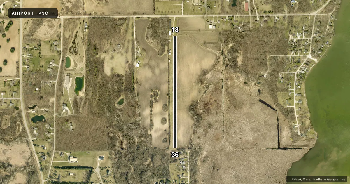
Airport sketch
Runways drawn to scale from FAA survey coordinates, rendered over satellite imagery. Not for navigation.
Approaches & charts
Services on the field
Fuel grades, oxygen, maintenance, ramp storage and lighting — as declared to the FAA by the airport operator.
Fuel & services
- Fuel
- Not available
- Oxygen (bottled)
- Not available
- Oxygen (bulk)
- Not available
- Airframe repair
- Major
- Power plant repair
- Major
Ramp & ground
- Transient storage
- Tie-down
- Landing fee
- No fee published
- Wind indicator
- Yes
- Segmented circle
- No
Fuel & FBOs
Cheapest 100LL and Jet A on the field and nearby. Always confirm with the FBO before taxi.
Airport notes
Surface conditions, obstructions, local procedures, lighting outages and other notes published with each FAA cycle.
General notes
- ARPT NOT PLWD; CFM CONDS WITH AMGR.
- DEER & BIRDS ON AND INVOF ARPT.
- FOR CD CTC CHICAGO ARTCC AT 630-906-8921.
Approach & departure obstructions
- 18MKD WITH ORANGE/WHITE A-FRAMES.
- 36MKD WITH ORANGE/WHITE A-FRAMES.
- 18CTLG OBST EXCEEDS 45 DEG SLP.
- 36CTLG OBST EXCEEDS 45 DEG SLP.
Other notes
- PRVDD THR DSPLCD SO AS TO PRVD A MINIMUM OF 20-1 CLNC OVER ALL OBSTNS IN APCH AREA; ALL TFC PAT OPNS CONDUCTED ON THE E SIDE OF N/S RWY.
- MANAGERELLIOTTEIDEN3@GMAIL.COM.
VFR map & nearby airports
VFR sectional. Tap any ICAO chip to open that airport.
Key facts · 49C
Answer card- ICAO
- 49C
- Name
- CAMP LAKE
- Location
- CAMP LAKE, WISCONSIN
- Elevation
- 749 ft MSL
- Traffic pattern altitude
- 1,349 ft MSL (600 AGL)
- Control tower
- Non-towered (use CTAF)
- Total runways
- 1
- Longest runway
- 18/36 · 2,210 ft
- Published ILS approaches
- 0
- Published frequencies
- 1
- Magnetic variation
- 1°
- Current flight rules
- LIFR
- Current wind
- 110° at 18 kt
- Favored runway now
- RWY 18
Camp Lake Airport sits in Camp Lake, Wisconsin. The field elevation is 749 ft MSL. It has one runway, 18/36, which is 2,210 ft of turf. The airport is not towered. CTAF is 122.9. No ILS approaches are published.
Pattern altitude is 600 ft AGL, which is 1,349 ft MSL. Traffic pattern work is conducted on the east side of the north-south runway. That matters here because the published remarks also call out displaced thresholds and obstacle clearance on both ends. Runway 18 and runway 36 are marked with orange and white A-frames. Cataloged obstacles exceed a 45 degree slope at both runway ends. Plan your arrival and departure with care.
The airport has deer and birds in the area. That is worth keeping in mind on taxi, takeoff and landing. The field is not permitted. Confirm conditions with the airport manager before you go. For clearance delivery, Chicago ARTCC is listed in the remarks. There are no on-field FBOs listed in the facts. Contact the airport operator directly or call the field on CTAF for current service details before arrival.