METAR & TAF C81
C81 does not publish a METAR.
Showing the nearest reporting station: KUGN (WAUKEGAN NTL) · 10.9 NM away. Conditions at C81 may differ.
METAR · KUGN
Observed 11:31Z
KUGN 271131Z 19005KT 5SM BR OVC004 26/26 A2983 RMK AO2 T02610256
- Wind
- 190° @ 5 kt
- Visibility
- 5 SM
- Temp / Dew
- 26°C / 26°C
- Altimeter
- 29.83 inHg
- Clouds
- OVC
- Density alt
- 2,409 ft
- Ceiling
- 400 ft AGL
- Rules
- LIFR
Airport info & contacts
Manager on record, flight service, ARTCC, attendance schedule and pattern altitude — published by the FAA and refreshed every 28 days.
Location
- From city
- 2 NM SW
- VFR sectional
- CHICAGO
- Pattern altitude
- 800 ft AGL · 1,588 ft MSL
- ARTCC
- ZAU · CHICAGO
- NOTAM facility
- IKK (NOTAM-D)
Airport manager
- Name
- DEAN MOHOMMAD
- Phone
- 773-240-1650
- Address
- 22731 W. TOWNLINE ROAD, GRAYSLAKE IL 60030
Flight service · Hours
- FSS IKK
- KANKAKEE1-800-WX-BRIEF
- Attendance
- MON-FRI · 0830-1600
- SAT-SUN · UNATTENDED
Frequencies
Tap any row to copy the frequency to your clipboard.
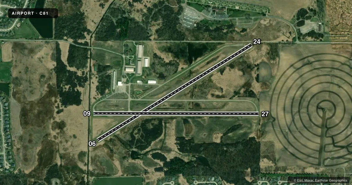
Runways & pattern
Full pagePattern entry · RWY 24
LEFT TRAFFIC| Runway | Heading (°M) | Length | Surface | Traffic |
|---|---|---|---|---|
| 06/24Favored | 56° / 236° | 3,573 ft | ASPH-TURF | Standard L |
| 09/27 | 88° / 268° | 3,270 ft | ASPH | Standard L |
Runway end performance
| End | TORA | TODA | ASDA | LDA | VGSI | Approach lights | Obstruction |
|---|---|---|---|---|---|---|---|
| 06 | — | — | — | — | — | — | 16', trees, 253' from thr, 90' R of cntrln, slope 15 |
| 24 | — | — | — | — | — | — | 78', tree, 1540' from thr, 86' R of cntrln, slope 17 |
| 09 | — | — | — | — | TRIL(4°) | — | — |
| 27 | — | — | — | — | TRIL(4°) | — | — |
Declared distances in feet. TORA = takeoff run available, TODA = takeoff distance, ASDA = accelerate-stop, LDA = landing distance.
Airport sketch
Runways drawn to scale from FAA survey coordinates, rendered over satellite imagery. Not for navigation.
Approaches & charts
Services on the field
Fuel grades, oxygen, maintenance, ramp storage and lighting — as declared to the FAA by the airport operator.
Fuel & services
- Fuel
- 100LL
- Oxygen (bottled)
- Not available
- Oxygen (bulk)
- Not available
- Airframe repair
- Major
- Power plant repair
- Major
Ramp & ground
- Transient storage
- Tie-down
- Landing fee
- No fee published
- Customs
- Not available
- Lighting schedule
- SS-SR
- Beacon schedule
- SS-SR
- Beacon
- White / Green (civil land)(WG)
- Wind indicator
- Lighted
- Segmented circle
- No
Fuel & FBOs
Cheapest 100LL and Jet A on the field and nearby. Always confirm with the FBO before taxi.
Airport notes
Surface conditions, obstructions, local procedures, lighting outages and other notes published with each FAA cycle.
General notes
- NO TOUCH & GO LNDG PERMITTED.
- UNLGTD POWER LINES 167 FT AGL 3/4 MILE S OF RWY 09/27.
- NUMEROUS MIGRATORY BIRDS INVOF ARPT.
- TWYS WITH NSTD SPACING AND CLEARANCES INVOF RAMP APRON.
- FOR CD CTC CHICAGO APCH AT 847-289-0926.
Runway surface & condition
- 09/27RWY 09 & 27 NSTD TRIL OTS INDEFLY.
- 06/24SW 1000 FT TURF-GRVL.
- 09/27LIRL SPACING & LGT INTST VARIES.
Approach & departure obstructions
- 24+15 FT RD ADJ RWY END L & R.
- 24RWY 24 NSTD DSPLCD THLD WHITE STRIPE MKGS ONLY. MARKED FOR RY 06 ON SW BEGINNING OF PAVED SURFACE.
- 09NSTD TRIL OPR DUSK-DAWN.
- 27NSTD TRIL OPR DUSK-DAWN.
- 24APCH RATIO 23:1 AT DSPLCD THR.
Other notes
- THIS AIRPORT HAS BEEN SURVEYED BY THE NATIONAL GEODETIC SURVEY.
- MANAGEREMAIL ADDRESS: PJK201@AOL.COM (ALL LOWER CASE)
- 06/24PAVEMENT HAS SEVERAL AREAS OF DEPRESSIONS. RWY EDGES DROP OFF IN EXCESS OF 2 INCHES.
VFR map & nearby airports
VFR sectional. Tap any ICAO chip to open that airport.
Key facts · C81
Answer card- ICAO
- C81
- Name
- CAMPBELL
- Location
- GRAYSLAKE, ILLINOIS
- Elevation
- 788 ft MSL
- Traffic pattern altitude
- 1,588 ft MSL (800 AGL)
- Control tower
- Non-towered (use CTAF)
- Total runways
- 2
- Longest runway
- 06/24 · 3,573 ft
- Published ILS approaches
- 0
- Published frequencies
- 4
- Magnetic variation
- 2°
- Current flight rules
- LIFR
- Current wind
- 190° at 5 kt
- Favored runway now
- RWY 24
Campbell Airport sits in Grayslake, Illinois. The field elevation is 788 ft MSL. It has two runways. The longest is runway 06/24 at 3,573 ft. Runway 09/27 is 3,270 ft. There is no control tower. No ILS approaches are published. Pattern altitude is 800 ft AGL, which is 1,588 ft MSL.
Campbell Airport is a good place to brief carefully before arrival. The published remarks call out nonstandard taxiway spacing near the ramp apron. They also note unlighted power lines 167 ft AGL about three quarters of a mile south of runway 09/27. Runway 24 has a displaced threshold marking issue. Runway 06/24 also has pavement depressions and edge drop-offs greater than 2 inches. Birds are reported in the area. No touch-and-go landings are permitted.
Campbell Airport has one on-field FBO. Campbell Airport carries AVGAS 100LL. Call (847) 223-2200 for current service details. Chicago Approach handles clearance delivery. The published contact number is 847-289-0926. The airport uses CTAF 122.7 and UNICOM 122.7. If you are planning a first visit, review the current Chart Supplement for any operational changes before you go.