METAR & TAF 06C
Current METAR
Observed 10:35Z
K06C 271035Z AUTO 22004KT 1 3/4SM OVC003 26/26 A2985 RMK AO2 T02600258
- Wind
- 220° @ 4 kt
- Visibility
- 0.75 SM
- Temp / Dew
- 26°C / 26°C
- Altimeter
- 29.85 inHg
- Clouds
- OVC
- Density alt
- 2,400 ft
- Ceiling
- 300 ft AGL
- Rules
- LIFR
Airport info & contacts
Manager on record, flight service, ARTCC, attendance schedule and pattern altitude — published by the FAA and refreshed every 28 days.
Location
- From city
- 22 NM NW
- VFR sectional
- CHICAGO
- Pattern altitude
- 800 ft AGL · 1,601 ft MSL
- ARTCC
- ZAU · CHICAGO
- NOTAM facility
- IKK (NOTAM-D)
Airport manager
- Name
- ERIK TRYDAL
- Phone
- 847-923-3859
- Address
- 101 SCHAUMBURG COURT, SCHAUMBURG IL 60193
Flight service · Hours
- FSS IKK
- KANKAKEE1-800-WX-BRIEF
- Attendance
- OCT-APR · 0700-1900
- MAY-SEP · 0700-2000
Frequencies
Tap any row to copy the frequency to your clipboard.
Runways & pattern
Full pagePattern entry · RWY 29
LEFT TRAFFICRunway end performance
| End | TORA | TODA | ASDA | LDA | VGSI | Approach lights | Obstruction |
|---|---|---|---|---|---|---|---|
| 11 | — | — | — | — | PAPI 2-box right(3.25°) | — | 22', brush, 251' from thr, 32' R of cntrln, slope 2 |
| 29 | — | — | — | — | PAPI 2-box left(3°) | — | — |
Declared distances in feet. TORA = takeoff run available, TODA = takeoff distance, ASDA = accelerate-stop, LDA = landing distance.
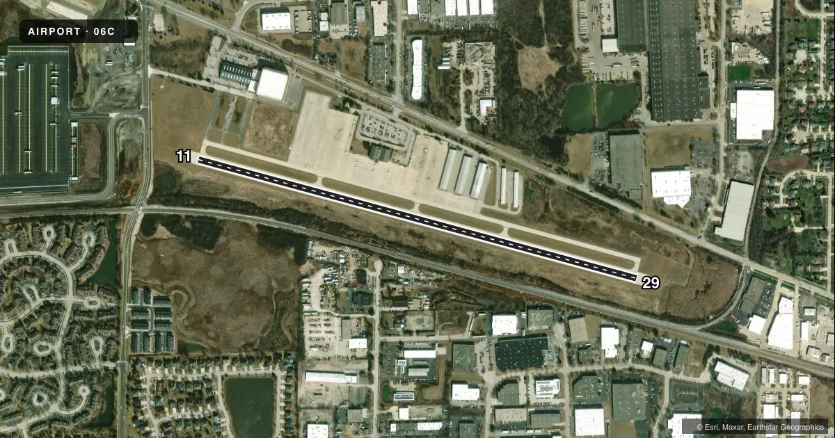
Airport sketch
Runways drawn to scale from FAA survey coordinates, rendered over satellite imagery. Not for navigation.
Approaches & charts
Services on the field
Fuel grades, oxygen, maintenance, ramp storage and lighting — as declared to the FAA by the airport operator.
Fuel & services
- Fuel
- 100LLA
- Oxygen (bottled)
- HIGH/LOW
- Oxygen (bulk)
- HIGH/LOW
- Airframe repair
- Major
- Power plant repair
- Major
- Other services
- AFRT,AMB,CHTR,INSTR,RNTL,SALES
Ramp & ground
- Transient storage
- Tie-down
- Hangar
- Landing fee
- No fee published
- Customs
- Not available
- Lighting schedule
- SEE RMK
- Beacon schedule
- SS-SR
- Beacon
- White / Green (civil land)(WG)
- Wind indicator
- Lighted
- Segmented circle
- No
Fuel & FBOs
Cheapest 100LL and Jet A on the field and nearby. Always confirm with the FBO before taxi.
Airport notes
Surface conditions, obstructions, local procedures, lighting outages and other notes published with each FAA cycle.
General notes
- FOR NOISE ABATEMENT PROCEDURES CTC AMGR 847-923-3778.
- WATER FOWL ON & INVOF RY 11/29.
- RY 29 PREFERED RY IN CALM & DIRECT CROSSWINDS. DEP ACFT FLY RY HEADING TO 1400 FT MSL BEFORE STARTING CROSSWIND TURN.
- BANNER TOWING PROHIBITED WITH IN 2 NM RADIUS OF ARPT.
- FOR CD CTC CHICAGO APCH AT 847-289-0926.
Lighting notes
- MIRL RY 11/29 PRESET LOW INTST; TO INCR INTST & ACTVT TWY LGTS & REILS RY 11 & RY 29 - CTAF.
Fuel notes
- 100LL100LL SELF SRVC FUEL AVAILABLE AFTER HRS.
Runway surface & condition
- 11/29HAS 100 FT STWY ON EACH END.
Other notes
- AND COOK COUNTY.
- MANAGEREMAIL ADDRESS: ETRYDAL@SCHAUMBURG.COM (ALL LWR CASE)
- MANAGERARPT ADMINISTRATOR.
- MANAGEREMERG CTC: 630-600-1439.
VFR map & nearby airports
VFR sectional. Tap any ICAO chip to open that airport.
Key facts · 06C
Answer card- ICAO
- 06C
- Name
- SCHAUMBURG RGNL
- Location
- CHICAGO/SCHAUMBURG, ILLINOIS
- Elevation
- 801 ft MSL
- Traffic pattern altitude
- 1,601 ft MSL (800 AGL)
- Control tower
- Non-towered (use CTAF)
- Total runways
- 1
- Longest runway
- 11/29 · 3,800 ft
- Published ILS approaches
- 0
- Published frequencies
- 2
- Magnetic variation
- 1°
- Current flight rules
- LIFR
- Current wind
- 220° at 4 kt
- Favored runway now
- RWY 29
Schaumburg Rgnl sits in Chicago/Schaumburg, Illinois. Field elevation is 801 ft MSL. The airport has one runway, 11/29, at 3,800 ft. It is not towered. CTAF and UNICOM are both 123.0. No ILS approaches are published here. Pattern altitude is 800 ft AGL, which is 1,601 ft MSL.
Holiday Airways is on the field. It carries AVGAS 100LL and Jet A Prist. Self-serve 100LL is available after hours. The runway has 100 ft stopways at each end. Medium intensity runway lights on 11/29 start at low intensity. Use CTAF to raise the lights and to activate taxiway lights plus runway end identifier lights for 11 and 29.
For a first trip, pay attention to the local operating notes. Banner towing is prohibited within 2 NM of the airport. Waterfowl are reported on and near runway 11/29. Runway 29 is the preferred runway in calm winds and direct crosswinds. Departing traffic flies runway heading to 1,400 ft MSL before turning crosswind. For noise abatement questions, contact the airport manager before you go. If you need clearance delivery, Chicago Approach is listed in the remarks. Check the current FAA Chart Supplement for any current local restrictions before flying in.