METAR & TAF KMDW
Current METAR
Observed 05:53Z
KMDW 270553Z 20007KT 10SM CLR 26/25 A2984 RMK AO2 SLP093 T02610250 10306 20261 403280217 56007 $
- Wind
- 200° @ 7 kt
- Visibility
- 10 SM
- Temp / Dew
- 26°C / 25°C
- Altimeter
- 29.84 inHg
- Clouds
- CLR
- Density alt
- 2,188 ft
- Ceiling
- Unlimited
- Rules
- VFR
Airport info & contacts
Manager on record, flight service, ARTCC, attendance schedule and pattern altitude — published by the FAA and refreshed every 28 days.
Location
- From city
- 9 NM SW
- VFR sectional
- CHICAGO
- ARTCC
- ZAU · CHICAGO
- NOTAM facility
- MDW (NOTAM-D)
Airport manager
- Name
- MICHAEL MCMURRAY
- Phone
- 773-686-8060
- Address
- 10510 WEST ZEMKE ROAD, CHICAGO IL 60666
Flight service · Hours
- FSS IKK
- KANKAKEE1-800-WX-BRIEF
- Attendance
- ALL
Frequencies
Tap any row to copy the frequency to your clipboard.
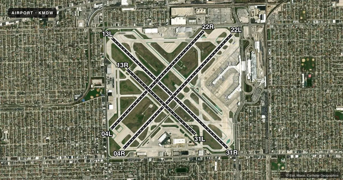
Runways & pattern
Full pagePattern entry · RWY 22L
LEFT TRAFFIC| Runway | Heading (°M) | Length | Surface | Traffic |
|---|---|---|---|---|
| 13L/31R | 130° / 310° | 6,522 ft | ASPH-CONC | Standard L |
| 04R/22LFavored | 39° / 219° | 6,445 ft | ASPH-CONC | Standard L |
| 04L/22R | 39° / 219° | 5,507 ft | ASPH | Standard L |
| 13R/31L | 130° / 310° | 3,859 ft | ASPH | Standard L |
Runway end performance
| End | TORA | TODA | ASDA | LDA | VGSI | Approach lights | Obstruction |
|---|---|---|---|---|---|---|---|
| 13L | 6,522' | 6,522' | 6,522' | 6,059' | PAPI 4-box right(3°) | RLLS | 15', road, 200' from thr, 225' R of cntrln, slope 0 |
| 31R | 6,522' | 6,522' | 6,522' | 5,826' | PAPI 4-box left(3°) | RLLS | 47', road, 200' from thr, 225' R of cntrln, slope 0 |
| 04R | 6,446' | 6,446' | 6,446' | 5,928' | PAPI 4-box left(3°) | — | 15', road, 200' from thr, 325' R of cntrln, slope 0 |
| 22L | 6,446' | 6,446' | 6,446' | 5,812' | PAPI 4-box right(3°) | — | 15', road, 200' from thr, 350' R of cntrln, slope 0 |
| 04L | 5,507' | 5,507' | 5,507' | 4,749' | PAPI 4-box left(3°) | — | 15', road, 200' from thr, 25' R of cntrln, slope 0 |
| 22R | 5,507' | 5,507' | 5,507' | 4,629' | PAPI 4-box left(3°) | — | 15', road, 200' from thr, 125' R of cntrln, slope 0 |
| 13R | — | — | — | — | — | — | 55', tree, 1504' from thr, 214' R of cntrln, slope 23 |
| 31L | — | — | — | — | — | — | 59', tree, 1737' from thr, 147' R of cntrln, slope 26 |
Declared distances in feet. TORA = takeoff run available, TODA = takeoff distance, ASDA = accelerate-stop, LDA = landing distance.
Airport sketch
Runways drawn to scale from FAA survey coordinates, rendered over satellite imagery. Not for navigation.
Approaches & charts
ILS · 3
Services on the field
Fuel grades, oxygen, maintenance, ramp storage and lighting — as declared to the FAA by the airport operator.
Fuel & services
- Fuel
- 100LLA1+
- Oxygen (bottled)
- Low pressure
- Oxygen (bulk)
- Low pressure
- Airframe repair
- Major
- Power plant repair
- Major
- Other services
- AFRT,AMB,AVNCS,CARGO,CHTR,INSTR
Ramp & ground
- Transient storage
- Tie-down
- Hangar
- Landing fee
- No fee published
- Customs
- Available
- Beacon schedule
- SS-SR
- Beacon
- White / Green (civil land)(WG)
- Wind indicator
- Lighted
- Segmented circle
- No
Fuel & FBOs
Cheapest 100LL and Jet A on the field and nearby. Always confirm with the FBO before taxi.
Airport notes
Surface conditions, obstructions, local procedures, lighting outages and other notes published with each FAA cycle.
General notes
- NOISE ABATEMENT PROCEDURES: ALL DEPARTURES ARE REQUESTED TO EXPEDITE CLIMB THROUGH 1500 FT MSL 2200-0600 DLY.
- ARPT CLSD TO SOLO STUDENT TRAINING.
- BIRDS ON & INVOF ARPT.
- CLOSE-IN OBST ALL RYS EXCEPT RY 13R/31L TOO NUMEROUS TO ITEMIZE.
- RY 22L PREFERRED DEP RY 2200-0700.
- TWY A CLSD TO ACFT OVR 94 FT WINGSPAN.
- TWY F CLSD TO ACFT OVR 94 FT WINGSPAN.
- RY 13R/31L CLSD TO FLT OPS WHEN ACFT OVR 79 FT WINGSPAN ARE ON TWY F.
- TWY N CLSD BTN TWY Y AND RWY 22L PAD.
Runway surface & condition
- 04L/22RPCR VALUE: 330/F/D/X/U
- 04R/22LPCR VALUE: 685/F/D/X/U
- 13L/31RPCR VALUE: 685/F/D/X/U
- 13R/31LPCR VALUE: 125/R/B/X/U
- 04L/22RRWY 04L/22R NOT AVBL FOR PART 121/PART 380 OPS WITH SKED PAX CARRYING OPS MORE THAN 9 PAX SEATS AND NON-SKED PAX CARRYING OPS MORE THAN 30 PAX SEATS.
- 13R/31LRWY 13R/31L NOT AVBL FOR PART 121/PART 380 OPS WITH SKED PAX CARRYING OPS MORE THAN 9 PAX SEATS AND NON-SKED PAX CARRYING OPS MORE THAN 30 PAX SEATS.
Approach & departure obstructions
- 04LRWY 04L APCH RATIO 19:1 AT DSPLCD THLD. TREES 178 FT L 1313 FT FROM DSPLCD THLD.
- 04RRWY 04R APCH RATIO 16:1 AT DSPLCD THLD. TREE 547 FT R 1122 FT FROM DSPLCD THLD.
- 13LRWY 13L APCH RATIO 16:1 AT DSPLCD THLD. TREE 453 FT R 915 FT FROM DSPLCD THLD.
- 22LRWY 22L APCH RATIO 19:1 AT DSPLCD THLD. LGT POLE 474 FT R 674 FT FROM DSPLCD THLD.
- 22RRWY 22R APCH RATIO 37:1 AT DSPLCD THR. TREE 2490 FT FROM DSPLCD THR 319 FT L.
- 31RRWY 31R APCH RATIO 24:1 AT DSPLCD THR. TREE 1211 FT FROM DSPLCD THR 459 FT R.
Arresting gear
- 04R_EMASENGINEERED MATERIALS ARRESTING SYSTEM (EMAS) 249 FT IN LENGTH BY 170 FT IN WIDTH LCTD AT THE DER 04R.
- 13L_EMASENGINEERED MATERIALS ARRESTING SYSTEM (EMAS) 190 FT IN LENGTH BY 170 FT IN WIDTH LCTD AT THE DER 13L.
- 22L_EMASENGINEERED MATERIALS ARRESTING SYSTEM (EMAS) 346 FT IN LENGTH BY 170 FT IN WIDTH LCTD AT THE DER 22L.
- 31R_EMASENGINEERED MATERIALS ARRESTING SYSTEM (EMAS) 210 FT IN LENGTH BY 170 FT IN WIDTH LCTD AT THE DER 31R.
Other notes
- ARFF INDEX "D" EQPT AVBL WITH 8 HRS NOTIFICATION TO ARPT OPNS 773-838-0677.
- MANAGERARPT OPNS 773-838-0677.
VFR map & nearby airports
VFR sectional. Tap any ICAO chip to open that airport.
Key facts · KMDW
Answer card- ICAO
- KMDW
- Name
- CHICAGO MIDWAY INTL
- Location
- CHICAGO, ILLINOIS
- Elevation
- 619.8 ft MSL
- Traffic pattern altitude
- 1,619.8 ft MSL (1,000 AGL)
- Control tower
- Towered · 24
- Total runways
- 4
- Longest runway
- 13L/31R · 6,522 ft
- Published ILS approaches
- 3
- Published frequencies
- 12
- Magnetic variation
- 4°
- Current flight rules
- VFR
- Current wind
- 200° at 7 kt
- Favored runway now
- RWY 22L
Chicago Midway Intl is in Chicago, Illinois. Field elevation is 619.8 ft MSL. The airport has 4 runways. The longest is 13L/31R at 6,522 ft. The tower is open 24 hours. There are 3 ILS approaches, with ILS service to runway ends 04R, 13L and 31R.
Pattern altitude is not published in the facts provided. Use the standard 1,000 ft AGL for light piston traffic unless the current FAA Chart Supplement says otherwise. Two on-field FBOs are confirmed. Signature Aviation carries 100LL and Jet A. Atlantic Aviation carries 100LL and Jet A.
This is a busy Class C airport in a major metro area. Expect heavy traffic and stay sharp on taxi instructions. Noise abatement is active. Departures are asked to climb through 1,500 ft MSL from 2200 to 0600 local. Birds are reported on and near the field. Several runways have EMAS at the departure end. Taxiway A is closed to aircraft over 94 ft wingspan. Taxiway N is closed between taxiway Y and the runway 22L pad. Close-in obstructions are noted on all runways except 13R/31L. Check current airport information before you go.