METAR & TAF KIGQ
Current METAR
Observed 20:15Z
KIGQ 242015Z AUTO 35004KT 10SM BKN060 OVC070 22/17 A3002 RMK AO2 T02190166
- Wind
- 350° @ 4 kt
- Visibility
- 10 SM
- Temp / Dew
- 22°C / 17°C
- Altimeter
- 30.02 inHg
- Clouds
- OVC
- Density alt
- 1,484 ft
- Ceiling
- 6,000 ft AGL
- Rules
- VFR
Airport info & contacts
Manager on record, flight service, ARTCC, attendance schedule and pattern altitude — published by the FAA and refreshed every 28 days.
Location
- From city
- 21 NM S
- VFR sectional
- CHICAGO
- ARTCC
- ZAU · CHICAGO
- NOTAM facility
- IGQ (NOTAM-D)
Airport manager
- Name
- BRIAN HANIGAN
- Phone
- (708) 418-5888
- Address
- 3250 BOB MALKAS DR, LANSING IL 60438
Flight service · Hours
- FSS IKK
- KANKAKEE1-800-WX-BRIEF
- Attendance
- 0700-1500
Frequencies
Tap any row to copy the frequency to your clipboard.
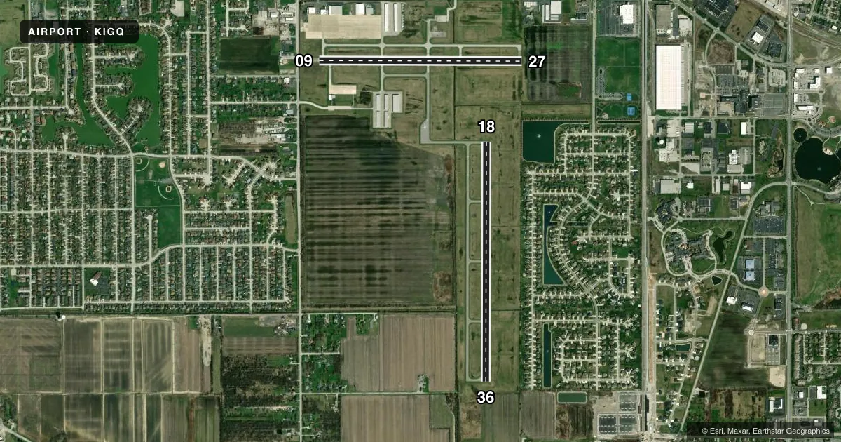
Runways & pattern
Full pagePattern entry · RWY 36
LEFT TRAFFIC| Runway | Heading (°M) | Length | Surface | Traffic |
|---|---|---|---|---|
| 18/36Favored | 178° / 358° | 4,002 ft | ASPH-TRTD | Standard L |
| 09/27 | 88° / 268° | 3,395 ft | ASPH-TRTD | Standard L |
Runway end performance
| End | TORA | TODA | ASDA | LDA | VGSI | Approach lights | Obstruction |
|---|---|---|---|---|---|---|---|
| 18 | — | — | — | — | PAPI 2-box left(3°) | — | — |
| 36 | — | — | — | — | PAPI 2-box left(3°) | — | — |
| 09 | — | — | — | — | PAPI 2-box left(3°) | — | 26', bldg, 546' from thr, 95' R of cntrln, slope 13 |
| 27 | — | — | — | — | PAPI 2-box left(3°) | — | — |
Declared distances in feet. TORA = takeoff run available, TODA = takeoff distance, ASDA = accelerate-stop, LDA = landing distance.
Airport sketch
Runways drawn to scale from FAA survey coordinates, rendered over satellite imagery. Not for navigation.
Approaches & charts
ILS · 1
Services on the field
Fuel grades, oxygen, maintenance, ramp storage and lighting — as declared to the FAA by the airport operator.
Fuel & services
- Fuel
- 100LLA
- Oxygen (bottled)
- HIGH/LOW
- Oxygen (bulk)
- HIGH/LOW
- Airframe repair
- Major
- Power plant repair
- Major
- Other services
- AFRT,AVNCS,CHTR,INSTR,RNTL,SALES
Ramp & ground
- Transient storage
- Tie-down
- Hangar
- Landing fee
- No fee published
- Customs
- Not available
- Lighting schedule
- SEE RMK
- Beacon schedule
- SS-SR
- Beacon
- White / Green (civil land)(WG)
- Wind indicator
- Lighted
- Segmented circle
- No
Fuel & FBOs
Cheapest 100LL and Jet A on the field and nearby. Always confirm with the FBO before taxi.
Airport notes
Surface conditions, obstructions, local procedures, lighting outages and other notes published with each FAA cycle.
General notes
- ALL PATTERN FLYING IN NOISE SENSITIVE AREA.
- BIRDS & WILDLIFE ON & INVOF ARPT.
- 146 FT TOWER 4325 FT FROM RY 27 665 FT RIGHT OF EXTENDED CNTRLN.
- FOR CD CTC CHICAGO APCH AT 847-289-0926.
Lighting notes
- ACTVT REIL RWY 09, 18, 27 & 36; MIRL RWY 09/27 & 18/36; TWY LGTS - CTAF. MIRL RWY 18/36 PRESET TO LOW INTST; INCR INTST - CTAF.
Fuel notes
- 100LLSELF SERVE FUEL AVBL H24 WITH CREDIT CARD.
Other notes
- EXISTED PRIOR TO 1959.
- MANAGEREMAIL ADDRESS: PPATLAK@VILLAGEOFLANSING.ORG (ALL LOWER CASE)
- MANAGER(708) 895-7200
VFR map & nearby airports
VFR sectional. Tap any ICAO chip to open that airport.
Key facts · KIGQ
Answer card- ICAO
- KIGQ
- Name
- LANSING MUNI
- Location
- CHICAGO, ILLINOIS
- Elevation
- 619.7 ft MSL
- Traffic pattern altitude
- 1,619.7 ft MSL (1,000 AGL)
- Control tower
- Non-towered (use CTAF)
- Total runways
- 2
- Longest runway
- 18/36 · 4,002 ft
- Published ILS approaches
- 1
- Published frequencies
- 4
- Magnetic variation
- 2°
- Current flight rules
- VFR
- Current wind
- 350° at 4 kt
- Favored runway now
- RWY 36
Lansing Muni is in Chicago, Illinois. Field elevation is 619.7 ft MSL. The airport has two runways. The longest is runway 18/36 at 4,002 ft. There is no control tower, so expect non-towered ops on CTAF 122.7. The field has one ILS approach to runway 36. Pattern altitude is not published. Use the standard 1,000 ft AGL for light piston traffic unless the current Chart Supplement says otherwise.
On the field, Lansing Municipal Airport and Midwest Business Center both carry 100LL and Jet A. Self-serve 100LL is available 24 hours with credit card. That is useful for late arrivals or early departures. Clearance delivery is handled through Chicago Approach. The published remarks also note that all pattern flying is in a noise sensitive area. Plan your downwind and base work with that in mind. There is also a 146 ft tower near runway 27, 4,325 ft from the threshold and 665 ft right of the extended centerline. Birds and wildlife are reported on and near the airport. Taxiway lights operate on CTAF. Runway end identifier lights are active on all four runway ends. Medium intensity runway lights are on both runways, with runway 18/36 set to low intensity by default and adjustable on CTAF.