METAR & TAF 3HO
3HO does not publish a METAR.
Showing the nearest reporting station: KGYY (GARY/CHICAGO INTL) · 7.7 NM away. Conditions at 3HO may differ.
METAR · KGYY
Observed 14:50Z
KGYY 261450Z 23005KT 7SM CLR 28/27 A2992
- Wind
- 230° @ 5 kt
- Visibility
- 7 SM
- Temp / Dew
- 28°C / 27°C
- Altimeter
- 29.92 inHg
- Clouds
- CLR
- Density alt
- 2,341 ft
- Ceiling
- Unlimited
- Rules
- VFR
Airport info & contacts
Manager on record, flight service, ARTCC, attendance schedule and pattern altitude — published by the FAA and refreshed every 28 days.
Location
- From city
- 2 NM NW
- VFR sectional
- CHICAGO
- ARTCC
- ZAU · CHICAGO
- NOTAM facility
- HUF (NOTAM-D)
Airport manager
- Name
- DON NIEMEYER
- Phone
- 219-962-3020
- Address
- 3600 N LAKE PARK AVENUE, HOBART IN 46342
Flight service · Hours
- FSS HUF
- TERRE HAUTE1-800-WX-BRIEF
- Attendance
- 0800-1700
Frequencies
Tap any row to copy the frequency to your clipboard.
Runways & pattern
Full pagePattern entry · RWY 18
LEFT TRAFFICRunway end performance
| End | TORA | TODA | ASDA | LDA | VGSI | Approach lights | Obstruction |
|---|---|---|---|---|---|---|---|
| 18 | — | — | — | — | — | — | 60', trees, 201' from thr, 0' R of cntrln, slope 0 |
| 36 | — | — | — | — | — | — | 70', trees, 201' from thr, 0' R of cntrln, slope 0 |
Declared distances in feet. TORA = takeoff run available, TODA = takeoff distance, ASDA = accelerate-stop, LDA = landing distance.
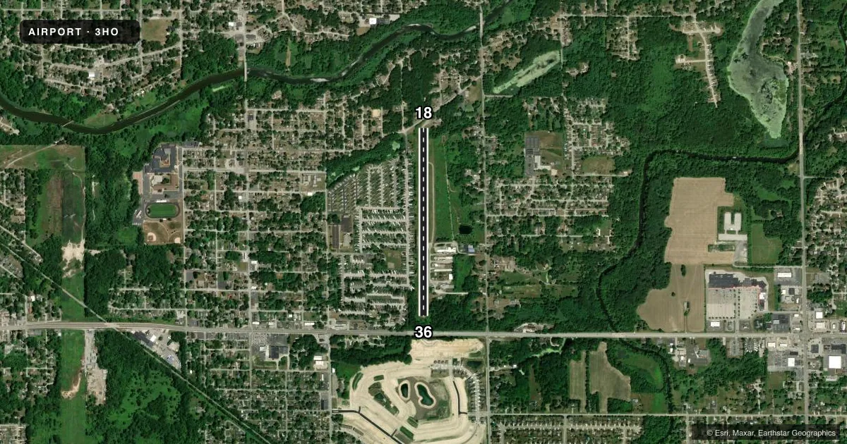
Airport sketch
Runways drawn to scale from FAA survey coordinates, rendered over satellite imagery. Not for navigation.
Approaches & charts
Services on the field
Fuel grades, oxygen, maintenance, ramp storage and lighting — as declared to the FAA by the airport operator.
Fuel & services
- Fuel
- 100LL
- Other services
- INSTR,RNTL
Ramp & ground
- Transient storage
- Tie-down
- Hangar
- Landing fee
- No fee published
- Customs
- Not available
- Wind indicator
- Yes
- Segmented circle
- No
Fuel & FBOs
Cheapest 100LL and Jet A on the field and nearby. Always confirm with the FBO before taxi.
Airport notes
Surface conditions, obstructions, local procedures, lighting outages and other notes published with each FAA cycle.
General notes
- TRAILER PARK 155 FT WEST OF RWY
- FOR CD CTC CHICAGO APCH AT 847-289-0926.
Approach & departure obstructions
- 1815 FT ROAD 130 FT FM RWY END
- 3640 FT TREES FM RWY END, 50 FT TO 70 FT L & R OF RWY
- 18NUMBERING SMALLER THAN STD & OFFSET TO L SIDE OF RWY. NON STD DSPLCD THLD MARKINGS.
- 36NUMBERING SMALLER THAN STD. NON STD DSPLCD THLD MARKINGS.
- 18APCH SLOPE 14:1 AT DSPLCD THR.
- 36APCH SLOPE 22:1.
Other notes
- EXISTED PRIOR TO 1959.
- 18/36RWY PAVEMENT & SHOULDER SPALLING. WEED GROWTH WITHIN RWY.
VFR map & nearby airports
VFR sectional. Tap any ICAO chip to open that airport.
Key facts · 3HO
Answer card- ICAO
- 3HO
- Name
- HOBART SKY RANCH
- Location
- HOBART, INDIANA
- Elevation
- 630.1 ft MSL
- Traffic pattern altitude
- 1,630.1 ft MSL (1,000 AGL)
- Control tower
- Non-towered (use CTAF)
- Total runways
- 1
- Longest runway
- 18/36 · 3,125 ft
- Published ILS approaches
- 0
- Published frequencies
- 2
- Magnetic variation
- 1°
- Current flight rules
- VFR
- Current wind
- 230° at 5 kt
- Favored runway now
- RWY 18
Hobart Sky Ranch is in Hobart, Indiana. Field elevation is 630.1 ft MSL. The airport has one runway. Runway 18/36 is 3,125 ft long with an asphalt surface. There is no control tower. CTAF and UNICOM are both 122.8.
No ILS approaches are published here. Pattern altitude is not published, so use the standard 1,000 ft AGL for light piston operations unless the current Chart Supplement says otherwise. The field has several published runway notes that matter on a first visit. Runway 18 and runway 36 both have non-standard displaced threshold markings. Runway 18 is offset to the left side of the runway. Runway 36 numbering is smaller than standard. The runway pavement and shoulders are spalling. There is weed growth within the runway.
The published remarks also call out obstacles near both ends. Runway 36 has 40-foot trees near the departure end. Runway 18 has a road about 130 feet from the runway end. There is also a trailer park about 155 feet west of the runway. This is a field where a careful stabilized approach matters. The airport sits in the Chicago area, so check current airspace and any local operating notes before you go. For clearance delivery, Chicago Approach is listed in the remarks. FBO options vary. Contact the airport operator directly before arrival, or call the field on CTAF/UNICOM for current FBO availability.