METAR & TAF IN7
IN7 does not publish a METAR.
Showing the nearest reporting station: KIGQ (LANSING MUNI) · 10.6 NM away. Conditions at IN7 may differ.
METAR · KIGQ
Observed 05:55Z
KIGQ 240555Z AUTO 00000KT 10SM CLR 14/12 A3016 RMK AO2 T01400120 10203 20135 402150120
- Wind
- 000° @ 0 kt
- Visibility
- 10 SM
- Temp / Dew
- 14°C / 12°C
- Altimeter
- 30.16 inHg
- Clouds
- CLR
- Density alt
- 440 ft
- Ceiling
- Unlimited
- Rules
- VFR
Airport info & contacts
Manager on record, flight service, ARTCC, attendance schedule and pattern altitude — published by the FAA and refreshed every 28 days.
Location
- From city
- 1 NM NE
- VFR sectional
- CHICAGO
- ARTCC
- ZAU · CHICAGO
- NOTAM facility
- HUF
Airport manager
- Name
- KENTON TURNER
- Phone
- 317-232-0935
- Address
- 402 W WASHINGTON ST, INDIANAPOLIS IN 46204
Flight service · Hours
- FSS HUF
- TERRE HAUTE1-800-WX-BRIEF
Frequencies
Tap any row to copy the frequency to your clipboard.
Runways & pattern
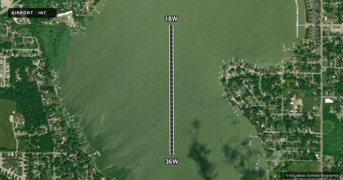
Full pagePattern entry · RWY 18W
LEFT TRAFFICAirport sketch
Runways drawn to scale from FAA survey coordinates, rendered over satellite imagery. Not for navigation.
Approaches & charts
Services on the field
Fuel grades, oxygen, maintenance, ramp storage and lighting — as declared to the FAA by the airport operator.
Fuel & services
- Fuel
- Not available
Ramp & ground
- Transient storage
- Not published
Fuel & FBOs
Cheapest 100LL and Jet A on the field and nearby. Always confirm with the FBO before taxi.
Airport notes
Surface conditions, obstructions, local procedures, lighting outages and other notes published with each FAA cycle.
VFR map & nearby airports
VFR sectional. Tap any ICAO chip to open that airport.
Key facts · IN7
Answer card- ICAO
- IN7
- Name
- CEDAR LAKE
- Location
- CEDAR LAKE, INDIANA
- Elevation
- 692 ft MSL
- Traffic pattern altitude
- 1,692 ft MSL (1,000 AGL)
- Control tower
- Non-towered (use CTAF)
- Total runways
- 1
- Longest runway
- 18W/36W · 2,675 ft
- Published ILS approaches
- 0
- Published frequencies
- 1
- Magnetic variation
- –
- Current flight rules
- VFR
- Current wind
- 000° at 0 kt
- Favored runway now
- –
Cedar Lake Airport (IN7) sits in Cedar Lake, Indiana. Field elevation is 692 ft MSL. It has one runway. The longest is 18W/36W at 2,675 ft on water. There is no control tower. CTAF is 122.9.
No ILS approaches are published here. Pattern altitude is not published in the facts, so use standard traffic pattern planning for light piston aircraft unless the current Chart Supplement says otherwise. The runway headings are listed as magnetic in the airport data. Magnetic variation is unknown in the facts. Verify your heading picture before you go.
There are no on-field FBOs listed. Plan on confirming services with the airport operator or the FBO directly by phone before arrival. If you need fuel or other support, do not assume it is available on the field.
This is a water runway field, so your first-time planning should focus on surface conditions, local traffic and a clean radio picture on CTAF. Check the current Chart Supplement for any published noise or operating notes before flying in. If you are coming in from the Chicago area, keep an eye on the surrounding airspace and verify your route on the current sectional or TAC.