METAR & TAF KVPZ
Current METAR
Observed 22:56Z
KVPZ 252256Z AUTO 22008KT 10SM OVC024 24/19 A2998 RMK AO2 SLP149 T02390189
- Wind
- 220° @ 8 kt
- Visibility
- 10 SM
- Temp / Dew
- 24°C / 19°C
- Altimeter
- 29.98 inHg
- Clouds
- OVC
- Density alt
- 1,961 ft
- Ceiling
- 2,400 ft AGL
- Rules
- MVFR
Airport info & contacts
Manager on record, flight service, ARTCC, attendance schedule and pattern altitude — published by the FAA and refreshed every 28 days.
Location
- From city
- 1 NM SE
- VFR sectional
- CHICAGO
- ARTCC
- ZAU · CHICAGO
- NOTAM facility
- VPZ (NOTAM-D)
Airport manager
- Name
- KYLE J. KUEBLER
- Phone
- 219-462-6508
- Address
- 4207 MURVIHILL RD, VALPARAISO IN 46383
Flight service · Hours
- FSS HUF
- TERRE HAUTE1-800-WX-BRIEF
- Attendance
- MON-FRI · 0600-2200
- SAT-SUN · 0700-1900
Frequencies
Tap any row to copy the frequency to your clipboard.
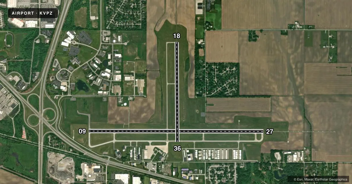
Runways & pattern
Full pagePattern entry · RWY 18
LEFT TRAFFIC| Runway | Heading (°M) | Length | Surface | Traffic |
|---|---|---|---|---|
| 09/27 | 88° / 268° | 7,001 ft | ASPH | Standard L |
| 18/36Favored | 178° / 358° | 4,001 ft | ASPH | Standard L |
Runway end performance
| End | TORA | TODA | ASDA | LDA | VGSI | Approach lights | Obstruction |
|---|---|---|---|---|---|---|---|
| 09 | 7,000' | 7,000' | 7,000' | 6,500' | PAPI 4-box left(3°) | — | 60', trees, 1212' from thr, 402' R of cntrln, slope 16 |
| 27 | 6,500' | 6,500' | 6,500' | 6,500' | PAPI 4-box left(3°) | MALSR | — |
| 18 | 4,001' | 4,001' | 4,001' | 4,001' | PAPI 2-box left(3°) | — | 80', trees, 2850' from thr, 0' R of cntrln, slope 33 |
| 36 | 4,001' | 4,001' | 4,001' | 4,001' | PAPI 2-box left(3°) | — | 32', trees, 966' from thr, 180' R of cntrln, slope 23 |
Declared distances in feet. TORA = takeoff run available, TODA = takeoff distance, ASDA = accelerate-stop, LDA = landing distance.
Airport sketch
Runways drawn to scale from FAA survey coordinates, rendered over satellite imagery. Not for navigation.
Approaches & charts
ILS · 1
Services on the field
Fuel grades, oxygen, maintenance, ramp storage and lighting — as declared to the FAA by the airport operator.
Fuel & services
- Fuel
- 100LLA
- Oxygen (bottled)
- Not available
- Oxygen (bulk)
- Not available
- Airframe repair
- Major
- Power plant repair
- Major
- Other services
- CHTR,INSTR,RNTL
Ramp & ground
- Transient storage
- Tie-down
- Hangar
- Landing fee
- No fee published
- Customs
- Not available
- Lighting schedule
- SEE RMK
- Beacon schedule
- SS-SR
- Beacon
- White / Green (civil land)(WG)
- Wind indicator
- Lighted
- Segmented circle
- Yes
Fuel & FBOs
Cheapest 100LL and Jet A on the field and nearby. Always confirm with the FBO before taxi.
Airport notes
Surface conditions, obstructions, local procedures, lighting outages and other notes published with each FAA cycle.
General notes
- BIRDS & DEER ON & INVOF ARPT.
- FOR CD CTC SOUTH BEND APCH AT 574-251-2609. WHEN SOUTH BEND APCH CLSD, FOR CD CTC CHICAGO ARTCC AT 630-906-8921.
Lighting notes
- ACTVT MALSR RWY 27; REIL RWY 9, 18 & 36; PAPI RWY 9, 18, 27 & 36; HIRL RWY 09/27; MIRL RWY 18/36 - CTAF. HIRL RWY 09/27; MIRL RWY 18/36; PRESET TO LOW INTST DUSK - 2300, INCR INTST - CTAF.
Runway surface & condition
- 09/27PCR VALUE: 405/F/C/X/T
- 18/36PCR VALUE: 140/F/C/X/T
- 09/27RWY 09/27 NOT AVBL FOR PART 121/PART 380 OPS WITH SKED PAX CARRYING OPS MORE THAN 9 PAX SEATS AND NON-SKED PAX CARRYING OPS MORE THAN 30 PAX SEATS. 90 DAY PPR FOR UNSKED ACR OPS GTR THAN 30 PAX SEATS - CALL AMGR.
- 18/36RWY 18/36 NOT AVBL FOR PART 121/PART 380 OPS WITH SKED PAX CARRYING OPS MORE THAN 9 PAX SEATS AND NON-SKED PAX CARRYING OPS MORE THAN 30 PAX SEATS. 90 DAY PPR FOR UNSKED ACR OPS GTR THAN 30 PAX SEATS - CALL AMGR.
Approach & departure obstructions
- 18UNUSBL BYD 8 DEG RIGHT OF CNTRLN.
- 27UNUSBL BYD 7 DEG RIGHT OF CNTRLN.
- 36UNUSBL BYD 8 DEG RIGHT OF CNTRLN.
- 27+96 FT MKD PLINE 5601 FT FM RWY END PERPENDICULAR TO CNTRLN 56:1 SLOPE.
VFR map & nearby airports
VFR sectional. Tap any ICAO chip to open that airport.
Key facts · KVPZ
Answer card- ICAO
- KVPZ
- Name
- PORTER COUNTY RGNL
- Location
- VALPARAISO, INDIANA
- Elevation
- 770.3 ft MSL
- Traffic pattern altitude
- 1,770.3 ft MSL (1,000 AGL)
- Control tower
- Non-towered (use CTAF)
- Total runways
- 2
- Longest runway
- 09/27 · 7,001 ft
- Published ILS approaches
- 1
- Published frequencies
- 5
- Magnetic variation
- 2°
- Current flight rules
- MVFR
- Current wind
- 220° at 8 kt
- Favored runway now
- RWY 18
Porter County Regional Airport sits in Valparaiso, Indiana. The field elevation is 770.3 ft MSL. It has two asphalt runways. The longest is runway 09/27 at 7,001 ft. Runway 18/36 is 4,001 ft.
This is a non-towered field. CTAF and UNICOM are both 122.725. Clearance delivery goes through South Bend Approach at 574-251-2609 when that facility is open. When South Bend Approach is closed, use Chicago ARTCC at 630-906-8921. The airport has one ILS approach. It serves runway 27.
Pattern altitude is not published. Use 1,000 ft AGL for light piston traffic unless current local guidance says otherwise. That puts the standard pattern around 1,770 ft MSL here. The runway lighting is pilot controlled on CTAF. Runway 27 has MALSR. Runway 9, 18 and 36 have REIL. PAPI is available on all four runway ends.
The on-field FBO is Porter County Regional Airport. It carries 100LL and Jet A with Prist. Expect birds and deer in the area. There is also a marked power line near the runway 27 end. If you are flying a larger aircraft, note the published use limits on both runways. Check the current FAA Chart Supplement for any operating limits before arrival.