METAR & TAF KOXI
Current METAR
Observed 14:15Z
KOXI 241415Z AUTO 18006KT 10SM OVC070 20/12 A3012 RMK AO2
- Wind
- 180° @ 6 kt
- Visibility
- 10 SM
- Temp / Dew
- 20°C / 12°C
- Altimeter
- 30.12 inHg
- Clouds
- OVC
- Density alt
- 1,202 ft
- Ceiling
- 7,000 ft AGL
- Rules
- VFR
Airport info & contacts
Manager on record, flight service, ARTCC, attendance schedule and pattern altitude — published by the FAA and refreshed every 28 days.
Location
- From city
- 3 NM NW
- VFR sectional
- CHICAGO
- ARTCC
- ZAU · CHICAGO
- NOTAM facility
- HUF (NOTAM-D)
Airport manager
- Name
- PAM BEHARRY
- Phone
- 574-772-5001
- Address
- 1795 N 200 E, KNOX IN 46534
Flight service · Hours
- FSS HUF
- TERRE HAUTE1-800-WX-BRIEF
- Attendance
- 0800-1800
Frequencies
Tap any row to copy the frequency to your clipboard.
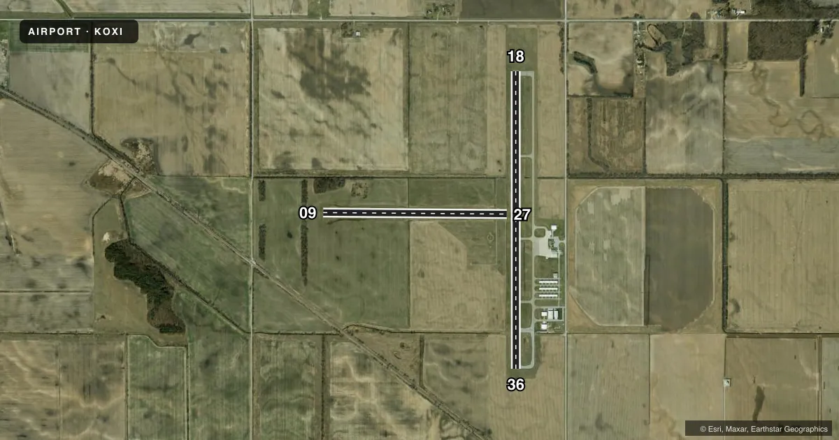
Runways & pattern
Full pagePattern entry · RWY 18
RIGHT TRAFFIC| Runway | Heading (°M) | Length | Surface | Traffic |
|---|---|---|---|---|
| 18/36Favored | 179° / 359° | 5,002 ft | ASPH | 18 R |
| 09/27 | 89° / 269° | 3,096 ft | TURF | Standard L |
Runway end performance
| End | TORA | TODA | ASDA | LDA | VGSI | Approach lights | Obstruction |
|---|---|---|---|---|---|---|---|
| 18 | — | — | — | — | PAPI 2-box left(3°) | — | 10', crops, 170' R of cntrln, slope 0 |
| 36 | — | — | — | — | PAPI 2-box left(3°) | — | 10', crops, 160' R of cntrln, slope 0 |
| 09 | — | — | — | — | — | — | 10', crops, 0' R of cntrln, slope 0 |
| 27 | — | — | — | — | — | — | 28', bldg, 190' R of cntrln, slope 26 |
Declared distances in feet. TORA = takeoff run available, TODA = takeoff distance, ASDA = accelerate-stop, LDA = landing distance.
Airport sketch
Runways drawn to scale from FAA survey coordinates, rendered over satellite imagery. Not for navigation.
Approaches & charts
Services on the field
Fuel grades, oxygen, maintenance, ramp storage and lighting — as declared to the FAA by the airport operator.
Fuel & services
- Fuel
- 100LLA+
- Other services
- AGRI
Ramp & ground
- Transient storage
- Tie-down
- Hangar
- Landing fee
- No fee published
- Customs
- Not available
- Lighting schedule
- SEE RMK
- Beacon schedule
- SS-SR
- Beacon
- White / Green (civil land)(WG)
- Wind indicator
- Lighted
- Segmented circle
- Yes
Fuel & FBOs
Cheapest 100LL and Jet A on the field and nearby. Always confirm with the FBO before taxi.
Airport notes
Surface conditions, obstructions, local procedures, lighting outages and other notes published with each FAA cycle.
General notes
- FOR CD CTC SOUTH BEND APCH AT 574-251-2609. WHEN SOUTH BEND APCH CLSD, FOR CD CTC CHICAGO ARTCC AT 630-906-8921.
- SELF SERVICE FUEL AVBL.
Lighting notes
- ACTVT REIL RWY 18 & 36 - CTAF; PAPI RWY 18 & 36 ON CONSLY.
Runway surface & condition
- 09/27BOUNDARY MKD BY YELLOW CONES.
Approach & departure obstructions
- 1810 FT CROPS 170 FT R OF RWY END
- 3610 FT CROPS 160 FT L OF RWY END
- 09DSPLCD THR MKD BY YELLOW CONES.
- 09APCH SLOPE 20:1 FM DSPLCD THR; 65 FT TREES 270 FT FM RWY END 100 FT L.
Other notes
- PROVIDED ALL TFC PAT OPERS ARE CONDUCTED ON THE W SIDE OF N/S RWY & ON THE N SIDE OF E/W RWY.
- 1UNATNDD EASTER, MEMORIAL DAY, JULY 4TH, LABOR DAY, THANKSGIVING, CHRISTMAS EVE & DAY UNLESS APREQ.
VFR map & nearby airports
VFR sectional. Tap any ICAO chip to open that airport.
Key facts · KOXI
Answer card- ICAO
- KOXI
- Name
- STARKE COUNTY
- Location
- KNOX, INDIANA
- Elevation
- 685.3 ft MSL
- Traffic pattern altitude
- 1,685.3 ft MSL (1,000 AGL)
- Control tower
- Non-towered (use CTAF)
- Total runways
- 2
- Longest runway
- 18/36 · 5,002 ft
- Published ILS approaches
- 0
- Published frequencies
- 4
- Magnetic variation
- 1°
- Current flight rules
- VFR
- Current wind
- 180° at 6 kt
- Favored runway now
- RWY 18
Starke County Airport is in Knox, Indiana. Field elevation is 685.3 ft MSL. The airport has two runways. The longest is runway 18/36 at 5,002 ft. Runway 09/27 is turf at 3,096 ft. There is no control tower, so use CTAF 122.8 for local traffic. No ILS approaches are published here.
Pattern altitude is not published. Use the standard 1,000 ft AGL pattern unless the current FAA Chart Supplement says otherwise. That puts the light piston pattern near 1,685 ft MSL based on the field elevation. Traffic is published on the west side of the north-south runway. Traffic is on the north side of the east-west runway.
Starke County Airport is on the field. It carries 100LL and Jet A with Prist. Self-serve fuel is available. For clearance delivery, call South Bend Approach at 574-251-2609. When South Bend Approach is closed, call Chicago ARTCC at 630-906-8921. Runway 18 and 36 end identifier lights activate on CTAF. The PAPI on 18 and 36 runs continuously. Watch the published obstructions near both ends of 18/36. There are crops near the runway ends. Runway 09 has a displaced threshold marked by yellow cones. The airport is unattended on several major holidays unless prior permission is requested.