METAR & TAF KPPO
Current METAR
Observed 12:55Z
KPPO 241255Z AUTO VRB01KT 10SM BKN075 16/16 A3014 RMK AO2
- Wind
- VAR @ 1 kt
- Visibility
- 10 SM
- Temp / Dew
- 16°C / 16°C
- Altimeter
- 30.14 inHg
- Clouds
- BKN
- Density alt
- 854 ft
- Ceiling
- 7,500 ft AGL
- Rules
- VFR
Airport info & contacts
Manager on record, flight service, ARTCC, attendance schedule and pattern altitude — published by the FAA and refreshed every 28 days.
Location
- From city
- 3 NM S
- VFR sectional
- CHICAGO
- ARTCC
- ZAU · CHICAGO
- NOTAM facility
- HUF (NOTAM-D)
Airport manager
- Name
- ERIC BOBCEK
- Phone
- 219-324-3393
- Address
- 2341 STATE RD 39S, LA PORTE IN 46350
Flight service · Hours
- FSS HUF
- TERRE HAUTE1-800-WX-BRIEF
- Attendance
- MON-FRI · 0700-1700
- SAT-SUN · 0800-1700
Frequencies
Tap any row to copy the frequency to your clipboard.
Runways & pattern
Full pagePattern entry · RWY 02
LEFT TRAFFIC| Runway | Heading (°M) | Length | Surface | Traffic |
|---|---|---|---|---|
| 02/20Favored | 17° / 197° | 5,000 ft | ASPH | Standard L |
| 14/32 | 132° / 312° | 2,797 ft | ASPH | Standard L |
Runway end performance
| End | TORA | TODA | ASDA | LDA | VGSI | Approach lights | Obstruction |
|---|---|---|---|---|---|---|---|
| 02 | — | — | — | — | PAPI 2-box left(3°) | — | 10', crops, 201' from thr, 240' R of cntrln, slope 0 |
| 20 | — | — | — | — | PAPI 2-box left(3.45°) | — | 10', crops, 201' from thr, 160' R of cntrln, slope 0 |
| 14 | — | — | — | — | — | — | 10', crops, 201' from thr, 0' R of cntrln, slope 0 |
| 32 | — | — | — | — | PAPI 2-box left(3.5°) | — | 10', crops, 201' from thr, 0' R of cntrln, slope 0 |
Declared distances in feet. TORA = takeoff run available, TODA = takeoff distance, ASDA = accelerate-stop, LDA = landing distance.
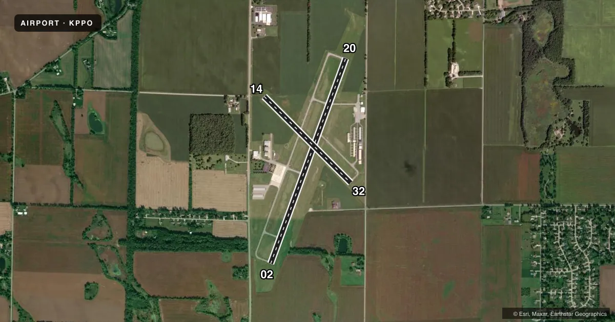
Airport sketch
Runways drawn to scale from FAA survey coordinates, rendered over satellite imagery. Not for navigation.
Approaches & charts
Services on the field
Fuel grades, oxygen, maintenance, ramp storage and lighting — as declared to the FAA by the airport operator.
Fuel & services
- Fuel
- 100LLAMOGAS
- Airframe repair
- Minor
- Power plant repair
- Minor
- Other services
- INSTR,RNTL
Ramp & ground
- Transient storage
- Tie-down
- Hangar
- Landing fee
- No fee published
- Customs
- Not available
- Lighting schedule
- SEE RMK
- Beacon schedule
- SS-SR
- Beacon
- White / Green (civil land)(WG)
- Wind indicator
- Lighted
- Segmented circle
- Yes
Fuel & FBOs
Cheapest 100LL and Jet A on the field and nearby. Always confirm with the FBO before taxi.
Airport notes
Surface conditions, obstructions, local procedures, lighting outages and other notes published with each FAA cycle.
General notes
- FARM EQUIP ON OR NEAR OPS AREAS.
- TWY LGTS AT TWY ENTRANCE ONLY.
- FOR CD CTC SOUTH BEND APCH AT 574-251-2609. WHEN SOUTH BEND APCH CLSD, FOR CD CTC CHICAGO ARTCC AT 630-906-8921.
- SVC AFT HR - 219-608-4707 OR 219-363-6659.
Lighting notes
- ACTVT REIL RWY 02, 14, 20, & 32; PAPI RWY 02, 20, & 32; MIRL RWY 02/20 & 14/32 - CTAF.
Fuel notes
- 100LLTRML FUEL AVBL DURG ATND HR OR SVC CALL. SELF SERVE FUEL H24 E SIDE.
Approach & departure obstructions
- 1410 FT CROPS 80 FT FM RWY END 75 FT R & 150 FT L.
- 2010 FT CROPS 160 FT L OF RWY END.
- 32UNUSBL BYD 2 DEGS LEFT OF CNTRLN.
- 14CLOSEST INTCP POINT.
- 32CLOSEST INTCP POINT.
- 14APCH SLOPE 35:1 FM DTHR.
Other notes
- EXISTED PRIOR TO 1959.
- OWNEREDWARD VOLK
VFR map & nearby airports
VFR sectional. Tap any ICAO chip to open that airport.
Key facts · KPPO
Answer card- ICAO
- KPPO
- Name
- LA PORTE MUNI
- Location
- LA PORTE, INDIANA
- Elevation
- 812 ft MSL
- Traffic pattern altitude
- 1,812 ft MSL (1,000 AGL)
- Control tower
- Non-towered (use CTAF)
- Total runways
- 2
- Longest runway
- 02/20 · 5,000 ft
- Published ILS approaches
- 0
- Published frequencies
- 4
- Magnetic variation
- 3°
- Current flight rules
- VFR
- Current wind
- 000° at 1 kt
- Favored runway now
- RWY 02
La Porte Muni Airport sits in La Porte, Indiana at 812 ft MSL. It has two asphalt runways. The longest is runway 02/20 at 5,000 ft. Runway 14/32 is 2,797 ft. There is no control tower. Pattern altitude is not published, so use the standard 1,000 ft AGL unless the current Chart Supplement says otherwise.
No ILS approaches are published here. For approach and departure work, South Bend Approach handles clearance delivery and radar services when available. If South Bend Approach is closed, clearance delivery goes through Chicago ARTCC. The field uses CTAF 123.0 and UNICOM 123.0. Runway lighting includes medium intensity lights on both runways. REIL is available on 02, 14, 20 and 32. PAPI is available on 02, 20 and 32.
LaPorte Municipal Airport is on the field. It carries AVGAS 100LL, JET A and MOGAS. Self-serve fuel is available 24 hours on the east side. Published remarks also call out farm equipment near the movement area. There are crop obstructions near runway 14 and runway 20. That makes a close look at the runway ends smart on arrival. The airport sits in flat terrain, so the main operational issues are runway length, lighting and local traffic. Check the current Chart Supplement for any noise or operating notes before you go.