METAR & TAF KGYY
Current METAR
Observed 00:50Z
KGYY 270050Z 18006KT 8SM CLR 29/25 A2985
- Wind
- 180° @ 6 kt
- Visibility
- 8 SM
- Temp / Dew
- 29°C / 25°C
- Altimeter
- 29.85 inHg
- Clouds
- CLR
- Density alt
- 2,507 ft
- Ceiling
- Unlimited
- Rules
- VFR
Airport info & contacts
Manager on record, flight service, ARTCC, attendance schedule and pattern altitude — published by the FAA and refreshed every 28 days.
Location
- From city
- 3 NM NW
- VFR sectional
- CHICAGO
- ARTCC
- ZAU · CHICAGO
- NOTAM facility
- GYY (NOTAM-D)
Airport manager
- Name
- DANIEL VICARI
- Phone
- 219-949-4925
- Address
- 6001-C AIRPORT RD, GARY IN 46406
Flight service · Hours
- FSS HUF
- TERRE HAUTE1-800-WX-BRIEF
- Attendance
- ALL
Frequencies
Tap any row to copy the frequency to your clipboard.
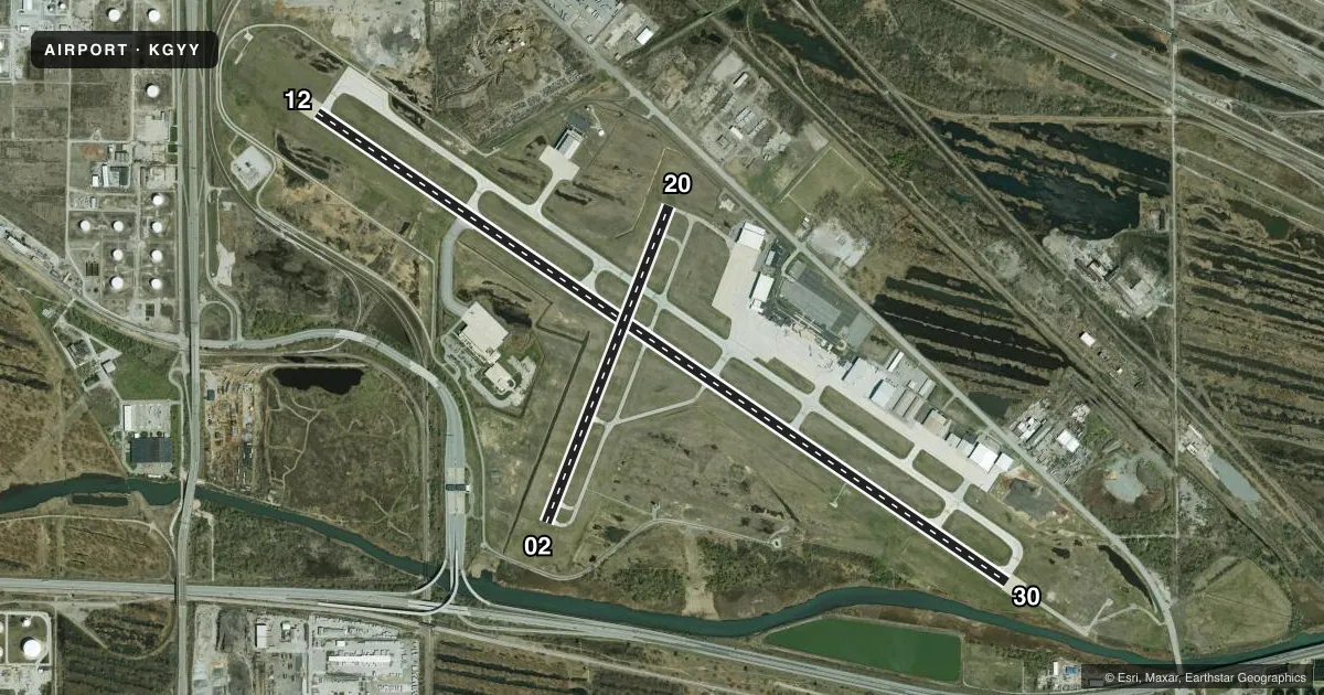
Runways & pattern
Full pagePattern entry · RWY 20
LEFT TRAFFIC| Runway | Heading (°M) | Length | Surface | Traffic |
|---|---|---|---|---|
| 12/30 | 122° / 302° | 8,859 ft | CONC | Standard L |
| 02/20Favored | 19° / 199° | 3,604 ft | ASPH | Standard L |
Runway end performance
| End | TORA | TODA | ASDA | LDA | VGSI | Approach lights | Obstruction |
|---|---|---|---|---|---|---|---|
| 12 | 8,859' | 8,859' | 7,959' | 7,959' | PAPI 4-box left(3°) | — | 93', ant, 3777' from thr, 1248' R of cntrln, slope 38 |
| 30 | 8,859' | 8,859' | 8,859' | 7,959' | PAPI 4-box left(3°) | MALSR | 68', pole, 3422' from thr, 220' R of cntrln, slope 47 |
| 02 | 3,604' | 3,604' | 3,604' | 3,604' | PAPI 2-box left(3°) | — | 42', road, 1050' from thr, 0' R of cntrln, slope 20 |
| 20 | 3,604' | 3,604' | 3,604' | 3,604' | PAPI 2-box left(3°) | — | 37', pole, 833' from thr, 289' R of cntrln, slope 17 |
Declared distances in feet. TORA = takeoff run available, TODA = takeoff distance, ASDA = accelerate-stop, LDA = landing distance.
Airport sketch
Runways drawn to scale from FAA survey coordinates, rendered over satellite imagery. Not for navigation.
Approaches & charts
ILS · 1
Services on the field
Fuel grades, oxygen, maintenance, ramp storage and lighting — as declared to the FAA by the airport operator.
Fuel & services
- Fuel
- 100LLA
- Oxygen (bottled)
- High pressure
- Airframe repair
- Major
- Power plant repair
- Major
- Other services
- CARGO,CHTR,INSTR,RNTL
Ramp & ground
- Transient storage
- Tie-down
- Hangar
- Landing fee
- Yes
- Customs
- Not available
- Lighting schedule
- SEE RMK
- Beacon schedule
- SS-SR
- Beacon
- White / Green (civil land)(WG)
- Wind indicator
- Lighted
- Segmented circle
- No
Fuel & FBOs
Cheapest 100LL and Jet A on the field and nearby. Always confirm with the FBO before taxi.
Airport notes
Surface conditions, obstructions, local procedures, lighting outages and other notes published with each FAA cycle.
General notes
- BIRDS & WILDLIFE ON & INVOF ARPT.
- UNCTLD VEHICLES N SIDE RAMPS.
- TWY A, A1-A8 & C NORTH OF RWY 12/30 AVBL TO ACR MORE THAN 9 PAX SEATS.
- TWY F MIL USE ONLY.
- LINE OF SIGHT NA BTN INTERSECTING RWY ENDS.
- ARNG: OPS 1230Z-2330Z++ TUES-FRI. MIL F/W OR R/W PRKG OR SVC ON ARNG RAMP 24 HR PPR - 219-977-2017.
- FOR CD WHEN ATCT IS CLSD CTC CHICAGO APCH AT 847-289-0926.
Lighting notes
- WHEN ATCT CLSD ACTVT MALSR RWY 30; REIL RWY 02, 12 & 20; MIRL RWY 02/20; HIRL RWY 12/30 - CTAF.
Runway surface & condition
- 02/20PCR VALUE: 121/R/C/X/U
- 12/30PCR VALUE: 706/R/C/X/U
- 02/20RWY 02/20 NOT AVBL FOR PART 121/PART 380 OPS WITH SKED PAX CARRYING OPS MORE THAN 9 PAX SEATS AND NON-SKED PAX CARRYING OPS MORE THAN 30 PAX SEATS.
Other notes
- CLSD TO SKED ACR OPS GTR THAN 9 PAX SEATS; UNSKED ACR OPS GTR THAN 30 PAX SEATS 1 HR PPR; INDEX B ARFF 1 HR PPR; INDEX C ARFF 4 HR PPR - 219-949-4910.
VFR map & nearby airports
VFR sectional. Tap any ICAO chip to open that airport.
Key facts · KGYY
Answer card- ICAO
- KGYY
- Name
- GARY/CHICAGO INTL
- Location
- GARY/CHICAGO, INDIANA
- Elevation
- 596.8 ft MSL
- Traffic pattern altitude
- 1,596.8 ft MSL (1,000 AGL)
- Control tower
- Towered · 0600-2300
- Total runways
- 2
- Longest runway
- 12/30 · 8,859 ft
- Published ILS approaches
- 1
- Published frequencies
- 6
- Magnetic variation
- 2°
- Current flight rules
- VFR
- Current wind
- 180° at 6 kt
- Favored runway now
- RWY 20
Gary/Chicago Intl sits in Gary, Indiana, near the Chicago metro area. Field elevation is 596.8 ft MSL. The airport has 2 runways. The longest is 8,859 ft on runway 12/30. The control tower is open daily from 0600 to 2300. One ILS approach is published for runway 30.
Pattern altitude is not published in the facts. Use the current Chart Supplement before you fly. The airport has two on-field FBOs. B. Coleman Aviation carries 100LL, Jet A and Jet A Prist. Gary Jet Center carries 100LL, Jet A and Jet A Prist. Runway 12/30 is the main runway for larger aircraft. Runway 02/20 is 3,604 ft. It is not available for certain scheduled passenger operations with larger seat counts.
A few operational notes matter here. The field has no line of sight between intersecting runway ends. Birds and wildlife are reported on and near the airport. When the tower is closed, lighting for runway 30 and the other runway ends is activated on CTAF. Taxiway F is for military use only. If you need arranged operations or special parking, check the current Chart Supplement or call the airport operator before arrival.