METAR & TAF C56
C56 does not publish a METAR.
Showing the nearest reporting station: KIGQ (LANSING MUNI) · 11.6 NM away. Conditions at C56 may differ.
METAR · KIGQ
Observed 07:55Z
KIGQ 270755Z AUTO 23005KT 2 1/2SM BR SCT005 24/24 A2986 RMK AO2 T02350235
- Wind
- 230° @ 5 kt
- Visibility
- 0.5 SM
- Temp / Dew
- 24°C / 24°C
- Altimeter
- 29.86 inHg
- Clouds
- SCT
- Density alt
- 2,134 ft
- Ceiling
- Unlimited
- Rules
- LIFR
Airport info & contacts
Manager on record, flight service, ARTCC, attendance schedule and pattern altitude — published by the FAA and refreshed every 28 days.
Location
- From city
- 3 NM SE
- VFR sectional
- CHICAGO
- ARTCC
- ZAU · CHICAGO
- NOTAM facility
- IKK (NOTAM-D)
Airport manager
- Name
- MARK THOMPSON
- Phone
- (708) 534-8282
- Address
- 28261 SOUTH KEDZIE AVE, MONEE IL 60449
Flight service · Hours
- FSS IKK
- KANKAKEE1-800-WX-BRIEF
- Attendance
- 0800-1700
Frequencies
Tap any row to copy the frequency to your clipboard.
Runways & pattern
Full pagePattern entry · RWY 27
LEFT TRAFFICRunway end performance
| End | TORA | TODA | ASDA | LDA | VGSI | Approach lights | Obstruction |
|---|---|---|---|---|---|---|---|
| 27 | — | — | — | — | — | — | 50', tree, 1204' from thr, 300' R of cntrln, slope 20 |
Declared distances in feet. TORA = takeoff run available, TODA = takeoff distance, ASDA = accelerate-stop, LDA = landing distance.
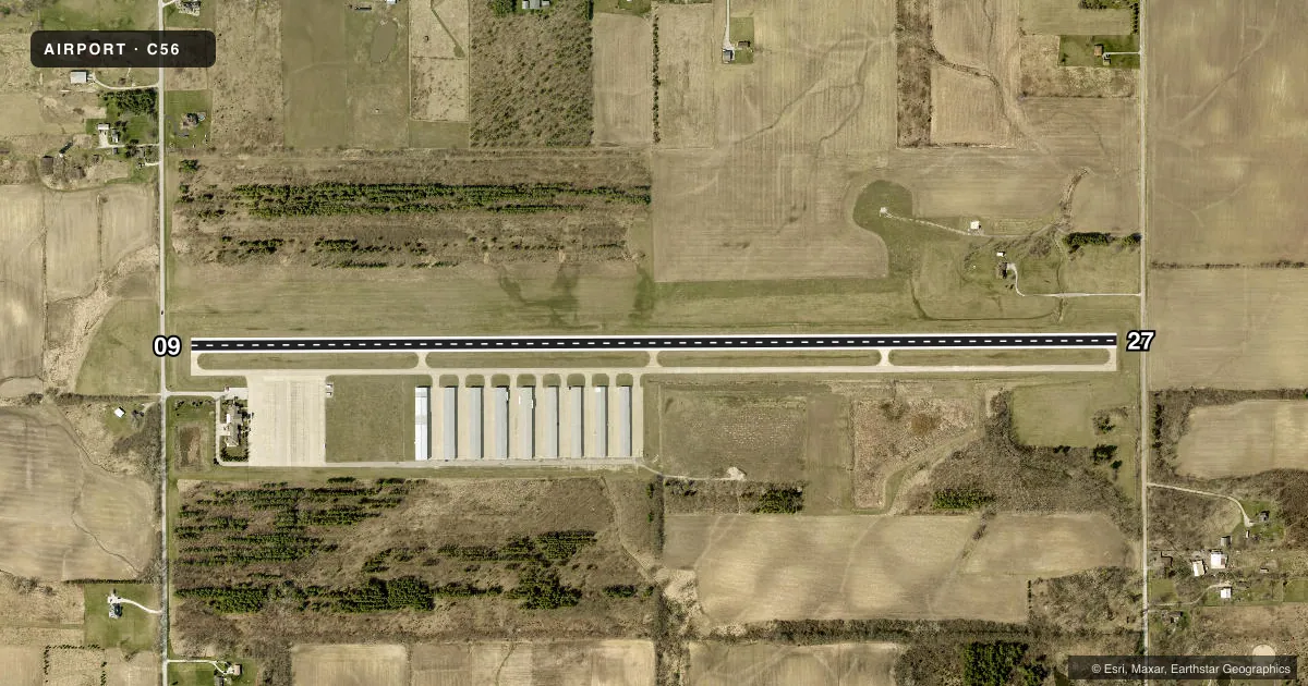
Airport sketch
Runways drawn to scale from FAA survey coordinates, rendered over satellite imagery. Not for navigation.
Approaches & charts
Services on the field
Fuel grades, oxygen, maintenance, ramp storage and lighting — as declared to the FAA by the airport operator.
Fuel & services
- Fuel
- 100LLA
Ramp & ground
- Transient storage
- Tie-down
- Hangar
- Landing fee
- No fee published
- Customs
- Not available
- Lighting schedule
- SS-SR
- Wind indicator
- Yes
- Segmented circle
- No
Fuel & FBOs
Cheapest 100LL and Jet A on the field and nearby. Always confirm with the FBO before taxi.
Airport notes
Surface conditions, obstructions, local procedures, lighting outages and other notes published with each FAA cycle.
General notes
- BIRDS AND ANIMALS ON AND INVOF OF ARPT.
- FOR CD CTC CHICAGO ARTCC AT 630-906-8921.
Fuel notes
- 100LL100LL FUEL AVBL H24 W/CREDIT CARD.
- AJET A AVBL AFT HR WITH PRIOR ARRANGEMENT.
Approach & departure obstructions
- 09RWY 27 12 FT ROAD 141 FT FM RWY END ON CL.
- 27RWY 09 8 FT ROAD 156 FT RWY END CL.
- 27CALM WND RWY.
Other notes
- EXISTED PRIOR TO 1959.
- 3708-534-8282
- MANAGEREMAIL ADDRESS: MTHOMPSON@BULTFIELD.COM (ALL LOWER CASE)
VFR map & nearby airports
VFR sectional. Tap any ICAO chip to open that airport.
Key facts · C56
Answer card- ICAO
- C56
- Name
- BULT FLD
- Location
- MONEE, ILLINOIS
- Elevation
- 790.2 ft MSL
- Traffic pattern altitude
- 1,790.2 ft MSL (1,000 AGL)
- Control tower
- Non-towered (use CTAF)
- Total runways
- 1
- Longest runway
- 09/27 · 5,001 ft
- Published ILS approaches
- 0
- Published frequencies
- 2
- Magnetic variation
- 3°
- Current flight rules
- LIFR
- Current wind
- 230° at 5 kt
- Favored runway now
- RWY 27
Bult Fld is in Monee, Illinois. The field elevation is 790.2 ft MSL. It has one runway, 09/27, which is 5,001 ft long and paved with concrete. This is a non-towered field. CTAF and UNICOM are both 123.0. No ILS approaches are published here.
The published pattern altitude is not listed, so plan on the standard 1,000 ft AGL for light piston operations unless the current Chart Supplement says otherwise. That puts the traffic pattern around 1,790.2 ft MSL. The on-field FBO is Bult Field. It carries AVGAS 100LL and Jet A. 100LL is available 24 hours with credit card. Jet A is available after hours with prior arrangement.
A few operational notes matter here. Runway 09 has an 8-foot road 156 feet from the runway end on centerline. Runway 27 has a 12-foot road 141 feet from the runway end on centerline. Birds and animals are reported on and near the airport. Calm wind favors the runway noted in the remarks. For clearance delivery, contact Chicago ARTCC at 630-906-8921. This is a good field to brief carefully before arrival, especially if you are planning a night stop or a fuel stop in changing wind conditions.