METAR & TAF 3KK
3KK does not publish a METAR.
Showing the nearest reporting station: KIKK (GREATER KANKAKEE) · 3.6 NM away. Conditions at 3KK may differ.
METAR · KIKK
Observed 18:15Z
KIKK 251815Z AUTO 20005KT 10SM OVC013 22/19 A3004 RMK AO2 T02150190
- Wind
- 200° @ 5 kt
- Visibility
- 10 SM
- Temp / Dew
- 22°C / 19°C
- Altimeter
- 30.04 inHg
- Clouds
- OVC
- Density alt
- 1,466 ft
- Ceiling
- 1,300 ft AGL
- Rules
- MVFR
Airport info & contacts
Manager on record, flight service, ARTCC, attendance schedule and pattern altitude — published by the FAA and refreshed every 28 days.
Location
- From city
- 3 NM SW
- VFR sectional
- CHICAGO
- Pattern altitude
- 800 ft AGL · 1,425 ft MSL
- ARTCC
- ZAU · CHICAGO
- NOTAM facility
- IKK (NOTAM-D)
Airport manager
- Name
- STEPHEN KOERNER
- Phone
- 815-932-4222
- Address
- 1520 SO. RT. 115, KANKAKEE IL 60901
Flight service · Hours
- FSS IKK
- KANKAKEE1-800-WX-BRIEF
- Attendance
- MON-FRI · 0700-1900
- SAT-SUN · IRREG
Frequencies
Tap any row to copy the frequency to your clipboard.
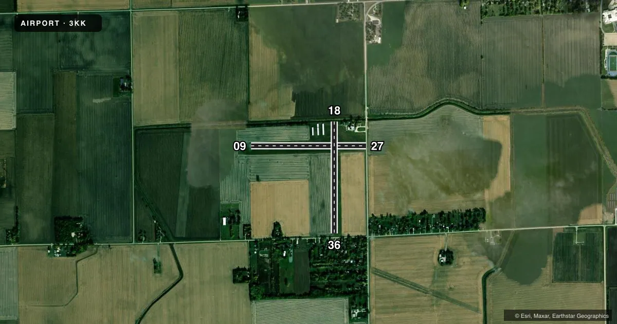
Runways & pattern
Full pagePattern entry · RWY 18
LEFT TRAFFIC| Runway | Heading (°M) | Length | Surface | Traffic |
|---|---|---|---|---|
| 09/27 | 89° / 269° | 2,644 ft | TURF | Standard L |
| 18/36Favored | 179° / 359° | 2,564 ft | TURF | Standard L |
Runway end performance
| End | TORA | TODA | ASDA | LDA | VGSI | Approach lights | Obstruction |
|---|---|---|---|---|---|---|---|
| 27 | — | — | — | — | — | — | 15', road, 15' from thr, 0' R of cntrln, slope 1 |
| 18 | — | — | — | — | — | — | 18', brush, 91' from thr, 0' R of cntrln, slope 5 |
| 36 | — | — | — | — | — | — | 46', trees, 47' from thr, 0' R of cntrln, slope 0 |
Declared distances in feet. TORA = takeoff run available, TODA = takeoff distance, ASDA = accelerate-stop, LDA = landing distance.
Airport sketch
Runways drawn to scale from FAA survey coordinates, rendered over satellite imagery. Not for navigation.
Approaches & charts
Services on the field
Fuel grades, oxygen, maintenance, ramp storage and lighting — as declared to the FAA by the airport operator.
Fuel & services
- Fuel
- Not available
- Oxygen (bottled)
- Not available
- Oxygen (bulk)
- Not available
- Airframe repair
- Major
- Power plant repair
- Major
- Other services
- INSTR,SALES
Ramp & ground
- Transient storage
- Tie-down
- Hangar
- Landing fee
- No fee published
- Customs
- Not available
- Lighting schedule
- SEE RMK
- Wind indicator
- Yes
- Segmented circle
- No
Fuel & FBOs
Cheapest 100LL and Jet A on the field and nearby. Always confirm with the FBO before taxi.
Airport notes
Surface conditions, obstructions, local procedures, lighting outages and other notes published with each FAA cycle.
General notes
- ULTRALIGHT ACTIVITY ON & INVOF ARPT.
- FOR CD CTC CHICAGO ARTCC AT 630-906-8921.
Lighting notes
- CTC MGR IN ADVANCE FOR RWY LGTS.
Runway surface & condition
- 09/27400 FT OVRN END OF RWY 27.
- 09/27NSTD LIRL; VARIABLE INTST & SPACING & NON-FRANGIBLE MOUNTINGS.
Approach & departure obstructions
- 27APCH SLP 20:1 TO DSPLCD THR.
- 36APCH SLP 15:1 DUE TO 63 FT TREE 990 FT FM DSPLCD THR.
- 27DSPLCD THR MKD WITH WHITE ROCKS.
- 36DSPLCD THR MKD WITH WHITE ROCKS.
Other notes
- EXISTED PRIOR TO 1959.
- MANAGEREMAIL ADDRESS: ALEX@KOERNERAVIATION.COM
VFR map & nearby airports
VFR sectional. Tap any ICAO chip to open that airport.
Key facts · 3KK
Answer card- ICAO
- 3KK
- Name
- KANKAKEE
- Location
- KANKAKEE, ILLINOIS
- Elevation
- 625 ft MSL
- Traffic pattern altitude
- 1,425 ft MSL (800 AGL)
- Control tower
- Non-towered (use CTAF)
- Total runways
- 2
- Longest runway
- 09/27 · 2,644 ft
- Published ILS approaches
- 0
- Published frequencies
- 2
- Magnetic variation
- 1°
- Current flight rules
- MVFR
- Current wind
- 200° at 5 kt
- Favored runway now
- RWY 18
Kankakee Airport (3KK) sits in Kankakee, Illinois. Field elevation is 625 ft MSL. The airport has two turf runways. The longest is Runway 09/27 at 2,644 ft. Runway 18/36 is 2,564 ft. There is no control tower. CTAF and UNICOM are both 122.8.
No ILS approaches are published here. Pattern altitude is 800 ft AGL, which is 1,425 ft MSL. That matters on a short turf field like this one. Runway 09/27 has nonstandard low intensity lights with variable intensity and spacing. The lights use non-frangible mountings. Contact the manager in advance for runway lights.
The published remarks also flag displaced thresholds on Runways 27 and 36. Runway 36 has a 63-foot tree 990 feet from the displaced threshold, so plan your arrival with that in mind. Runway 27 also has a 400-foot overrun beyond the end. Ultralight activity is on and near the airport, so keep a sharp scan in the pattern and on taxi. For clearance delivery, contact Chicago ARTCC at 630-906-8921. There are no on-field FBOs listed, so verify services with the airport operator or call the field directly before you go.